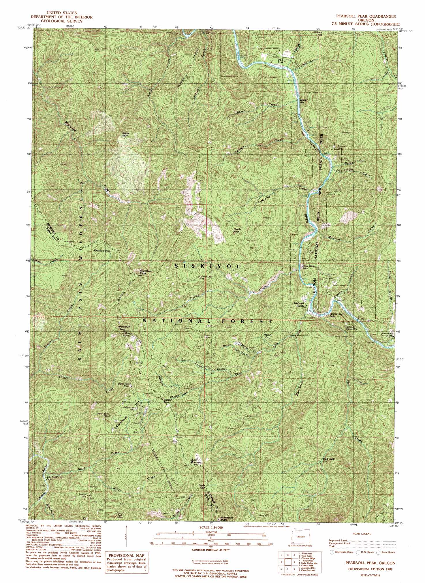
Pearsoll Peak Topo Map Oregon
To zoom in, hover over the map of Pearsoll Peak
USGS Topo Quad 42123c7 - 1:24,000 scale
| Topo Map Name: | Pearsoll Peak |
| USGS Topo Quad ID: | 42123c7 |
| Print Size: | ca. 21 1/4" wide x 27" high |
| Southeast Coordinates: | 42.25° N latitude / 123.75° W longitude |
| Map Center Coordinates: | 42.3125° N latitude / 123.8125° W longitude |
| U.S. State: | OR |
| Filename: | o42123c7.jpg |
| Download Map JPG Image: | Pearsoll Peak topo map 1:24,000 scale |
| Map Type: | Topographic |
| Topo Series: | 7.5´ |
| Map Scale: | 1:24,000 |
| Source of Map Images: | United States Geological Survey (USGS) |
| Alternate Map Versions: |
Pearsoll Peak OR 1989, updated 1989 Download PDF Buy paper map Pearsoll Peak OR 1998, updated 2001 Download PDF Buy paper map Pearsoll Peak OR 2011 Download PDF Buy paper map Pearsoll Peak OR 2014 Download PDF Buy paper map |
| FStopo: | US Forest Service topo Pearsoll Peak is available: Download FStopo PDF Download FStopo TIF |
1:24,000 Topo Quads surrounding Pearsoll Peak
Agness |
Brandy Peak |
Hobson Horn |
Mount Peavine |
Galice |
Horse Sign Butte |
Silver Peak |
York Butte |
Chrome Ridge |
Onion Mountain |
Big Craggies |
Tincup Peak |
Pearsoll Peak |
Eight Dollar Mountain |
Selma |
Quail Prairie Mountain |
Chetco Peak |
Josephine Mountain |
Cave Junction |
Holland |
Fourth Of July Creek |
Biscuit Hill |
Buckskin Peak |
O'Brien |
Takilma |
> Back to 42123a1 at 1:100,000 scale
> Back to 42122a1 at 1:250,000 scale
> Back to U.S. Topo Maps home
Pearsoll Peak topo map: Gazetteer
Pearsoll Peak: Bars
Miami Bar elevation 280m 918′Pearsoll Peak: Flats
Horse Flat elevation 519m 1702′Oak Flat elevation 265m 869′
School Flat elevation 525m 1722′
Sourdough Flat elevation 1058m 3471′
Pearsoll Peak: Gaps
Chetco Pass elevation 1087m 3566′Eagle Gap elevation 1134m 3720′
Pearsoll Peak: Mines
Albright Mine (historical) elevation 502m 1646′Bowser Mine elevation 806m 2644′
Chrome King Mine elevation 954m 3129′
Cox Mine (historical) elevation 935m 3067′
Deep Gorge Mine elevation 300m 984′
Eagles Nest Mine elevation 1199m 3933′
Eureka Mine elevation 745m 2444′
Fall Creek Copper Mine elevation 420m 1377′
Golden Dreams Mine (historical) elevation 1034m 3392′
Golden Eagle Mine (historical) elevation 696m 2283′
Hustis Mine (historical) elevation 679m 2227′
Little Siberia Mine elevation 1065m 3494′
Pearsoll Mine elevation 1445m 4740′
Peck Mine elevation 683m 2240′
Robertson Mine elevation 414m 1358′
Uncle Sam Mine elevation 1011m 3316′
Pearsoll Peak: Pillars
Castle Rock elevation 1000m 3280′Pearsoll Peak: Springs
Granite Spring elevation 1178m 3864′Pearsoll Peak: Streams
Babyfoot Creek elevation 407m 1335′Baker Creek elevation 274m 898′
Chetco Pass Creek elevation 973m 3192′
Crater Creek elevation 616m 2020′
Dailey Creek elevation 301m 987′
Fall Creek elevation 306m 1003′
Labrador Creek elevation 302m 990′
Lightning Creek elevation 280m 918′
Marsh Creek elevation 535m 1755′
Mill Creek elevation 621m 2037′
Miller Creek elevation 501m 1643′
Myrtle Creek elevation 318m 1043′
Nome Creek elevation 283m 928′
Oak Flat Creek elevation 282m 925′
O'Conner Creek elevation 282m 925′
Pearsoll Creek elevation 918m 3011′
Rancherie Creek elevation 303m 994′
Salmon Creek elevation 278m 912′
Slide Creek elevation 389m 1276′
Telephone Creek elevation 487m 1597′
Twin Cedars Creek elevation 687m 2253′
West Fork Rancherie Creek elevation 346m 1135′
Pearsoll Peak: Summits
Eagle Mountain elevation 1331m 4366′Gold Basin Butte elevation 1466m 4809′
Nome Peak elevation 1218m 3996′
Pearsoll Peak elevation 1537m 5042′
Whetstone Butte elevation 1350m 4429′
Pearsoll Peak: Valleys
Bills Gulch elevation 323m 1059′Five Finger Gulch elevation 328m 1076′
Knapke Gulch elevation 342m 1122′
McGuire Gulch elevation 319m 1046′
Store Gulch elevation 506m 1660′
Pearsoll Peak digital topo map on disk
Buy this Pearsoll Peak topo map showing relief, roads, GPS coordinates and other geographical features, as a high-resolution digital map file on DVD: