Gold Hill Topo Map Oregon
To zoom in, hover over the map of Gold Hill
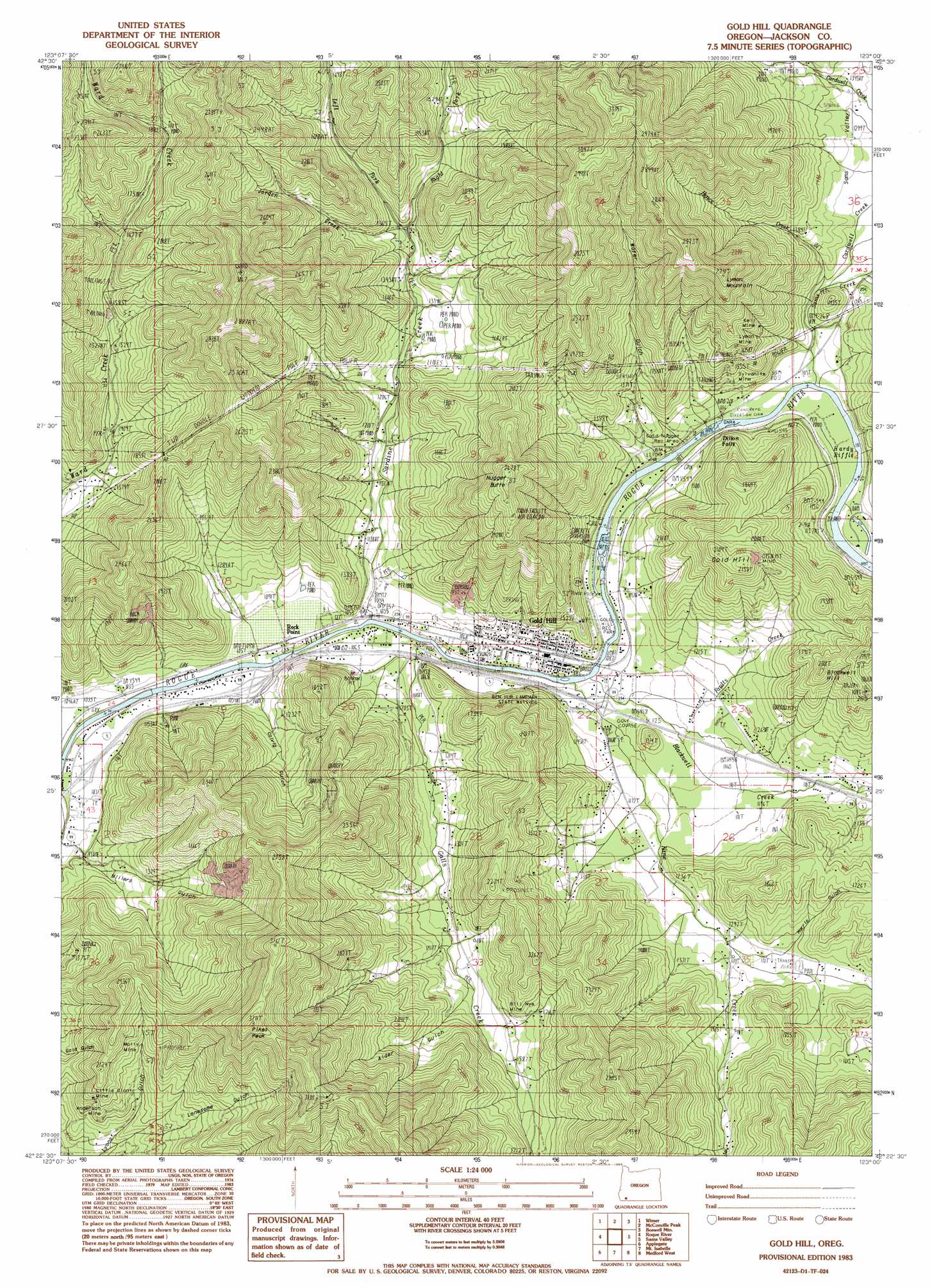
USGS Topo Quad 42123d1 - 1:24,000 scale
| Topo Map Name: | Gold Hill |
| USGS Topo Quad ID: | 42123d1 |
| Print Size: | ca. 21 1/4" wide x 27" high |
| Southeast Coordinates: | 42.375° N latitude / 123° W longitude |
| Map Center Coordinates: | 42.4375° N latitude / 123.0625° W longitude |
| U.S. State: | OR |
| Filename: | o42123d1.jpg |
| Download Map JPG Image: | Gold Hill topo map 1:24,000 scale |
| Map Type: | Topographic |
| Topo Series: | 7.5´ |
| Map Scale: | 1:24,000 |
| Source of Map Images: | United States Geological Survey (USGS) |
| Alternate Map Versions: |
Gold Hill OR 1983, updated 1983 Download PDF Buy paper map Gold Hill OR 2011 Download PDF Buy paper map Gold Hill OR 2014 Download PDF Buy paper map |
1:24,000 Topo Quads surrounding Gold Hill
Golden |
King Mountain |
Skeleton Mountain |
Cleveland Ridge |
Trail |
Sexton Mountain |
Wimer |
Mcconville Peak |
Boswell Mountain |
Shady Cove |
Grants Pass |
Rogue River |
Gold Hill |
Sams Valley |
Eagle Point |
Murphy |
Applegate |
Mount Isabelle |
Medford West |
Medford East |
Williams |
Tallowbox Mountain |
Ruch |
Sterling Creek |
Talent |
> Back to 42123a1 at 1:100,000 scale
> Back to 42122a1 at 1:250,000 scale
> Back to U.S. Topo Maps home
Gold Hill topo map: Gazetteer
Gold Hill: Canals
Gold Hill Irrigation District Canal elevation 325m 1066′Gold Hill: Falls
Dillon Falls elevation 333m 1092′Gold Hill: Mines
Anderson Mine elevation 529m 1735′Bill Nye Mine elevation 479m 1571′
Braden Mine elevation 512m 1679′
Kell Mine elevation 522m 1712′
Little Giant Mine elevation 563m 1847′
Lyman Mine elevation 535m 1755′
Molly Mine elevation 630m 2066′
Sylvanite Mine elevation 416m 1364′
Tinpan Mine elevation 953m 3126′
Gold Hill: Parks
Ben Hur Lampman State Park elevation 346m 1135′Fishers Ferry County Park elevation 359m 1177′
Gold Hill Regional Park elevation 329m 1079′
Gold Nugget County Recreation Area elevation 338m 1108′
Hardy Riffle County Park elevation 350m 1148′
Gold Hill: Populated Places
Dardanelles elevation 325m 1066′Gold Hill elevation 333m 1092′
Gold Hill: Post Offices
Dardanelles Post Office (historical) elevation 325m 1066′Gold Hill Post Office elevation 333m 1092′
Rock Point Post Office (historical) elevation 320m 1049′
Gold Hill: Rapids
Hardy Riffle elevation 347m 1138′Gold Hill: Reservoirs
Del Rio Reservoir elevation 338m 1108′Estramado Reservoir elevation 453m 1486′
Granger Reservoir elevation 342m 1122′
Magerly Reservoir elevation 582m 1909′
McCollum Reservoir elevation 329m 1079′
Vincent Reservoirs elevation 452m 1482′
Wiwona Reservoir elevation 378m 1240′
Gold Hill: Springs
Crystal Spring elevation 534m 1751′Domestic Spring elevation 477m 1564′
Shady Spring elevation 545m 1788′
Gold Hill: Streams
Blackwell Creek elevation 324m 1062′Cardwell Creek elevation 361m 1184′
East Fork Kane Creek elevation 390m 1279′
Faults Creek elevation 339m 1112′
Galls Creek elevation 329m 1079′
Hence Creek elevation 361m 1184′
Jorden Creek elevation 409m 1341′
Kane Creek elevation 330m 1082′
Left Fork Sardine Creek elevation 426m 1397′
Right Fork Sardine Creek elevation 429m 1407′
Rock Creek elevation 367m 1204′
Rock Creek elevation 363m 1190′
Rocky Creek elevation 367m 1204′
Sams Creek elevation 338m 1108′
Sardine Creek elevation 311m 1020′
Gold Hill: Summits
Blackwell Hill elevation 594m 1948′Gold Hill elevation 631m 2070′
Laurel Hill elevation 400m 1312′
Lyman Mountain elevation 726m 2381′
Nugget Butte elevation 814m 2670′
Pikes Peak elevation 971m 3185′
Gold Hill: Valleys
Alder Gulch elevation 433m 1420′Bear Gulch elevation 500m 1640′
China Gulch elevation 378m 1240′
Colvig Gulch elevation 347m 1138′
Harris Gulch elevation 416m 1364′
Sams Valley elevation 344m 1128′
Spring Gulch elevation 344m 1128′
Water Gulch elevation 330m 1082′
Gold Hill digital topo map on disk
Buy this Gold Hill topo map showing relief, roads, GPS coordinates and other geographical features, as a high-resolution digital map file on DVD: