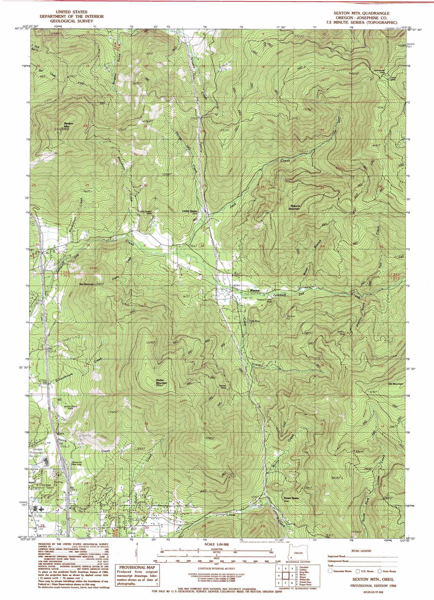
Sexton Mountain Topo Map Oregon
To zoom in, hover over the map of Sexton Mountain
USGS Topo Quad 42123e3 - 1:24,000 scale
| Topo Map Name: | Sexton Mountain |
| USGS Topo Quad ID: | 42123e3 |
| Print Size: | ca. 21 1/4" wide x 27" high |
| Southeast Coordinates: | 42.5° N latitude / 123.25° W longitude |
| Map Center Coordinates: | 42.5625° N latitude / 123.3125° W longitude |
| U.S. State: | OR |
| Filename: | o42123e3.jpg |
| Download Map JPG Image: | Sexton Mountain topo map 1:24,000 scale |
| Map Type: | Topographic |
| Topo Series: | 7.5´ |
| Map Scale: | 1:24,000 |
| Source of Map Images: | United States Geological Survey (USGS) |
| Alternate Map Versions: |
Sexton Mtn OR 1986, updated 1986 Download PDF Buy paper map Sexton Mountain OR 1996, updated 1999 Download PDF Buy paper map Sexton Mountain OR 2011 Download PDF Buy paper map Sexton Mountain OR 2014 Download PDF Buy paper map |
| FStopo: | US Forest Service topo Sexton Mountain is available: Download FStopo PDF Download FStopo TIF |
1:24,000 Topo Quads surrounding Sexton Mountain
Rabbit Mountain |
Mccullough Creek |
Quines Creek |
Starvout Creek |
Cedar Springs Mountain |
Mount Reuben |
Glendale |
Golden |
King Mountain |
Skeleton Mountain |
Galice |
Merlin |
Sexton Mountain |
Wimer |
Mcconville Peak |
Onion Mountain |
Wilderville |
Grants Pass |
Rogue River |
Gold Hill |
Selma |
Murphy Mountain |
Murphy |
Applegate |
Mount Isabelle |
> Back to 42123e1 at 1:100,000 scale
> Back to 42122a1 at 1:250,000 scale
> Back to U.S. Topo Maps home
Sexton Mountain topo map: Gazetteer
Sexton Mountain: Airports
Josephine County Airport elevation 348m 1141′Sexton Mountain: Mines
Baby Mine elevation 668m 2191′Daisy Mine elevation 1108m 3635′
Gopher Mine elevation 703m 2306′
Hammersly Mine elevation 1164m 3818′
Lucky Queen Mine elevation 483m 1584′
Oak Mine elevation 510m 1673′
Orofino Mine elevation 900m 2952′
Twelve O'Clock Mine elevation 461m 1512′
Sexton Mountain: Post Offices
Hammersley Post Office (historical) elevation 1158m 3799′Lucky Queen Post Office (historical) elevation 436m 1430′
Mountain Post Office (historical) elevation 402m 1318′
Winona Post Office (historical) elevation 455m 1492′
Sexton Mountain: Streams
Breakdown Creek elevation 367m 1204′Cherry Creek elevation 383m 1256′
Corliss Creek elevation 530m 1738′
Corn Creek elevation 505m 1656′
Cove Creek elevation 420m 1377′
Dunlap Creek elevation 509m 1669′
Fall Creek elevation 549m 1801′
Horse Creek elevation 423m 1387′
Jack Creek elevation 402m 1318′
Morris Creek elevation 469m 1538′
Water Branch elevation 475m 1558′
Sexton Mountain: Summits
Red Mountain elevation 732m 2401′Roberts Mountain elevation 1125m 3690′
Sexton Mountain elevation 1164m 3818′
Walker Mountain elevation 1173m 3848′
Sexton Mountain: Valleys
Burgess Gulch elevation 403m 1322′King Gulch elevation 496m 1627′
Orofino Gulch elevation 604m 1981′
Shorthorn Gulch elevation 909m 2982′
Sexton Mountain digital topo map on disk
Buy this Sexton Mountain topo map showing relief, roads, GPS coordinates and other geographical features, as a high-resolution digital map file on DVD: