Mount Reuben Topo Map Oregon
To zoom in, hover over the map of Mount Reuben
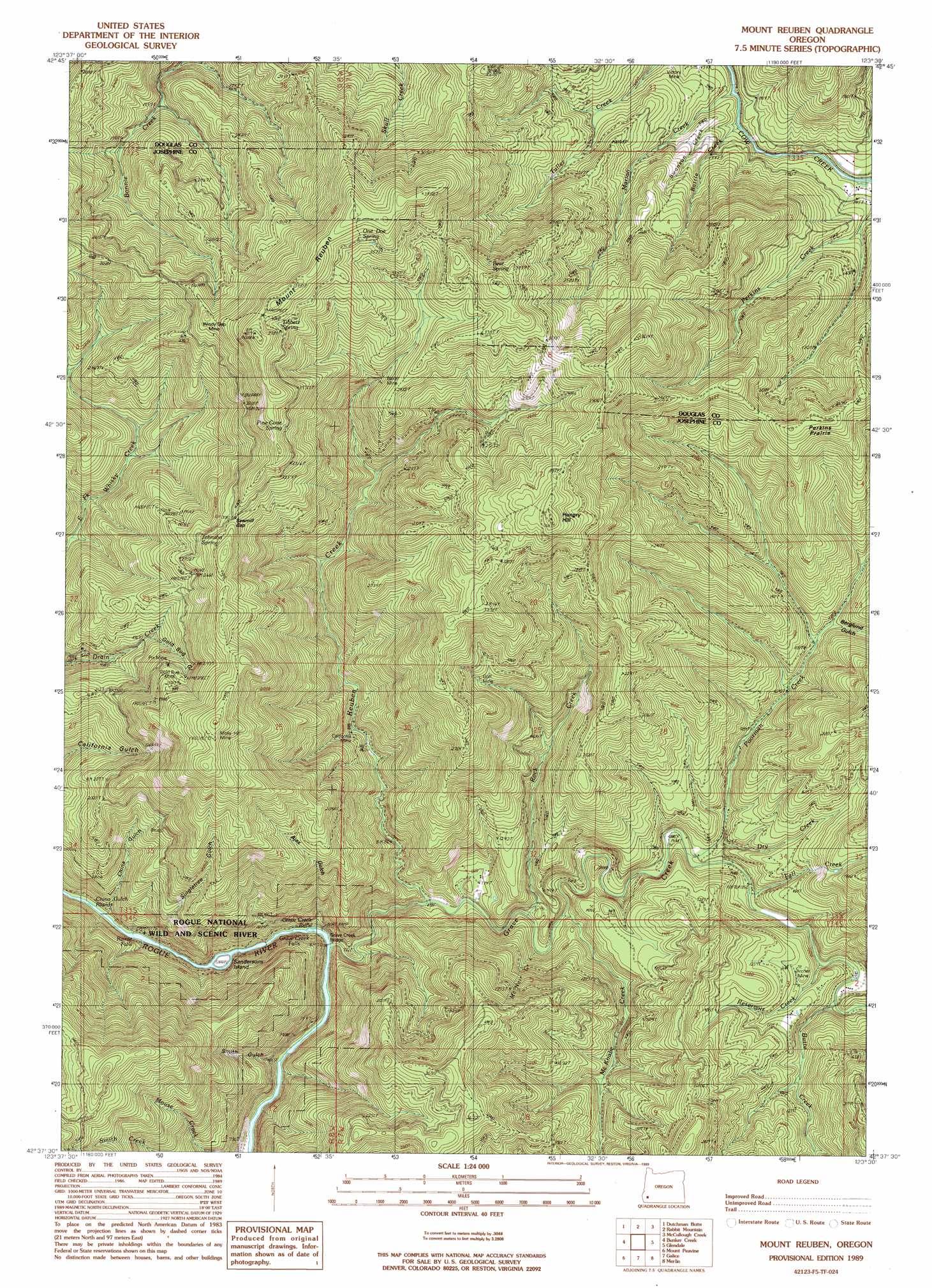
USGS Topo Quad 42123f5 - 1:24,000 scale
| Topo Map Name: | Mount Reuben |
| USGS Topo Quad ID: | 42123f5 |
| Print Size: | ca. 21 1/4" wide x 27" high |
| Southeast Coordinates: | 42.625° N latitude / 123.5° W longitude |
| Map Center Coordinates: | 42.6875° N latitude / 123.5625° W longitude |
| U.S. State: | OR |
| Filename: | o42123f5.jpg |
| Download Map JPG Image: | Mount Reuben topo map 1:24,000 scale |
| Map Type: | Topographic |
| Topo Series: | 7.5´ |
| Map Scale: | 1:24,000 |
| Source of Map Images: | United States Geological Survey (USGS) |
| Alternate Map Versions: |
Mount Reuben OR 1989, updated 1989 Download PDF Buy paper map Mount Reuben OR 1998, updated 2001 Download PDF Buy paper map Mount Reuben OR 2011 Download PDF Buy paper map Mount Reuben OR 2014 Download PDF Buy paper map |
| FStopo: | US Forest Service topo Mount Reuben is available: Download FStopo PDF Download FStopo TIF |
1:24,000 Topo Quads surrounding Mount Reuben
Bone Mountain |
Chipmunk Ridge |
Live Oak Mountain |
Nickel Mountain |
Canyonville |
Mount Bolivar |
Dutchman Butte |
Rabbit Mountain |
Mccullough Creek |
Quines Creek |
Kelsey Peak |
Bunker Creek |
Mount Reuben |
Glendale |
Golden |
Hobson Horn |
Mount Peavine |
Galice |
Merlin |
Sexton Mountain |
York Butte |
Chrome Ridge |
Onion Mountain |
Wilderville |
Grants Pass |
> Back to 42123e1 at 1:100,000 scale
> Back to 42122a1 at 1:250,000 scale
> Back to U.S. Topo Maps home
Mount Reuben topo map: Gazetteer
Mount Reuben: Bridges
Grave Creek Bridge elevation 244m 800′Mount Reuben: Falls
Grave Creek Falls elevation 194m 636′Rainie Falls elevation 180m 590′
Mount Reuben: Flats
Perkins Prairie elevation 855m 2805′Mount Reuben: Gaps
Sawmill Gap elevation 846m 2775′Mount Reuben: Mines
Ajax Mine elevation 718m 2355′Archer Mine elevation 349m 1145′
Baker Mine elevation 794m 2604′
Bantam Mine elevation 512m 1679′
California Mine elevation 350m 1148′
Goff Mine elevation 730m 2395′
Gold Bug Mine elevation 688m 2257′
J C L Mine elevation 452m 1482′
Molly Hill Mine elevation 1036m 3398′
Pix Mine elevation 1119m 3671′
Victory Mine elevation 480m 1574′
Windy Gap Mine elevation 849m 2785′
Mount Reuben: Rapids
China Gulch Rapids elevation 180m 590′Grave Creek Riffle elevation 187m 613′
Mount Reuben: Springs
Bear Spring elevation 1032m 3385′Johnson Spring elevation 856m 2808′
One Doe Spring elevation 1155m 3789′
Pine Cone Spring elevation 1093m 3585′
Tibbett Spring elevation 1138m 3733′
Mount Reuben: Streams
Battle Creek elevation 389m 1276′Butte Creek elevation 274m 898′
Dry Creek elevation 258m 846′
Fall Creek elevation 260m 853′
Grave Creek elevation 190m 623′
Harris Creek elevation 215m 705′
Marion Creek elevation 380m 1246′
McKnabe Creek elevation 229m 751′
McNair Creek elevation 375m 1230′
Panther Creek elevation 408m 1338′
Poorman Creek elevation 264m 866′
Reservoir Creek elevation 263m 862′
Reuben Creek elevation 215m 705′
Rock Creek elevation 238m 780′
Swanson Creek elevation 384m 1259′
Mount Reuben: Summits
Hungry Hill elevation 1104m 3622′Mount Reuben elevation 1133m 3717′
Mount Reuben: Valleys
Ajax Gulch elevation 257m 843′Berglund Gulch elevation 382m 1253′
China Gulch elevation 182m 597′
Gold Bug Gulch elevation 602m 1975′
Singletree Gulch elevation 181m 593′
Smith Gulch elevation 261m 856′
Mount Reuben digital topo map on disk
Buy this Mount Reuben topo map showing relief, roads, GPS coordinates and other geographical features, as a high-resolution digital map file on DVD: