Bunker Creek Topo Map Oregon
To zoom in, hover over the map of Bunker Creek
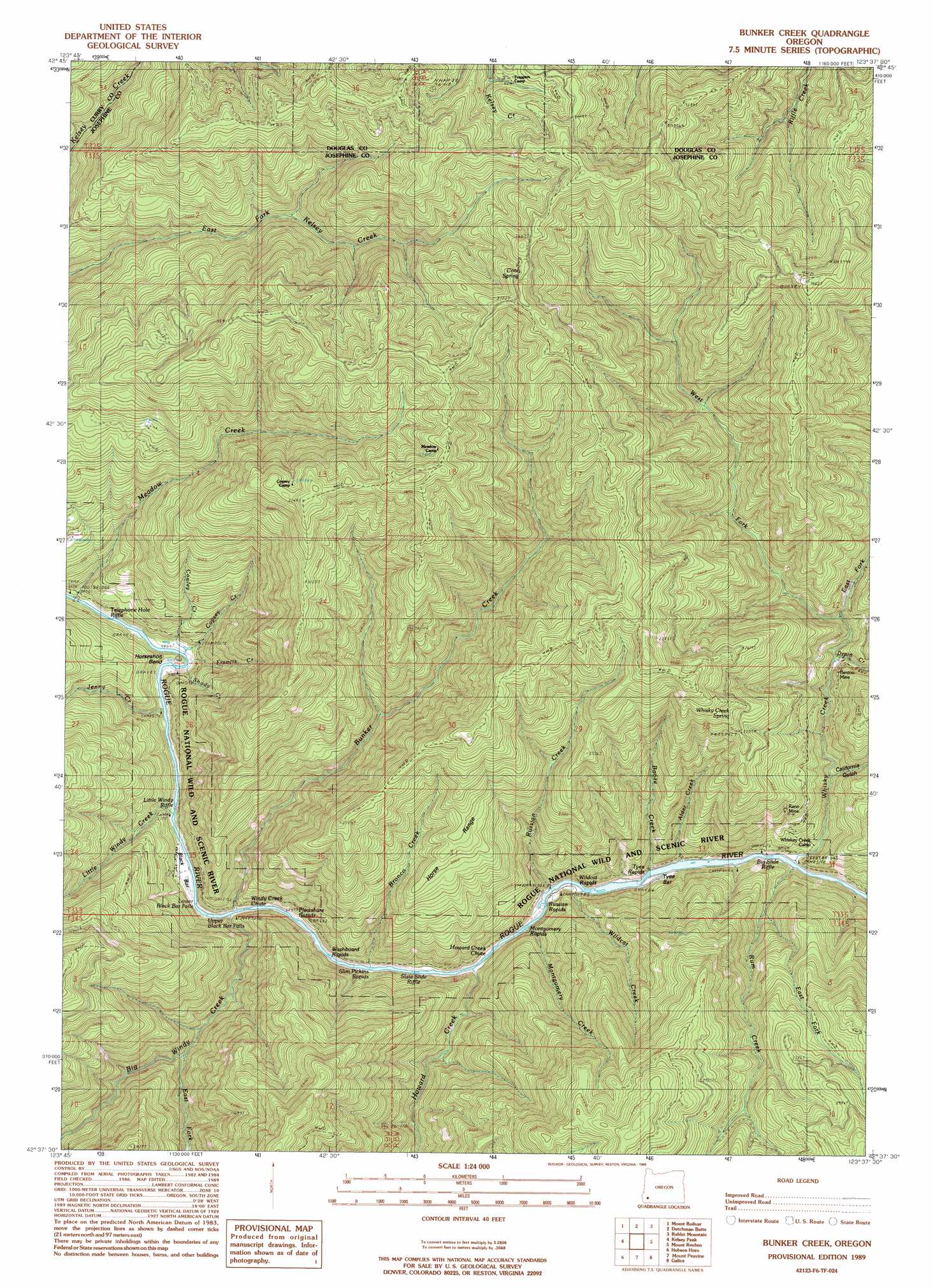
USGS Topo Quad 42123f6 - 1:24,000 scale
| Topo Map Name: | Bunker Creek |
| USGS Topo Quad ID: | 42123f6 |
| Print Size: | ca. 21 1/4" wide x 27" high |
| Southeast Coordinates: | 42.625° N latitude / 123.625° W longitude |
| Map Center Coordinates: | 42.6875° N latitude / 123.6875° W longitude |
| U.S. State: | OR |
| Filename: | o42123f6.jpg |
| Download Map JPG Image: | Bunker Creek topo map 1:24,000 scale |
| Map Type: | Topographic |
| Topo Series: | 7.5´ |
| Map Scale: | 1:24,000 |
| Source of Map Images: | United States Geological Survey (USGS) |
| Alternate Map Versions: |
Bunker Creek OR 1989, updated 1989 Download PDF Buy paper map Bunker Creek OR 1998, updated 2001 Download PDF Buy paper map Bunker Creek OR 2011 Download PDF Buy paper map Bunker Creek OR 2014 Download PDF Buy paper map |
| FStopo: | US Forest Service topo Bunker Creek is available: Download FStopo PDF Download FStopo TIF |
1:24,000 Topo Quads surrounding Bunker Creek
Rasler Creek |
Bone Mountain |
Chipmunk Ridge |
Live Oak Mountain |
Nickel Mountain |
Eden Ridge Valley |
Mount Bolivar |
Dutchman Butte |
Rabbit Mountain |
Mccullough Creek |
Marial |
Kelsey Peak |
Bunker Creek |
Mount Reuben |
Glendale |
Brandy Peak |
Hobson Horn |
Mount Peavine |
Galice |
Merlin |
Silver Peak |
York Butte |
Chrome Ridge |
Onion Mountain |
Wilderville |
> Back to 42123e1 at 1:100,000 scale
> Back to 42122a1 at 1:250,000 scale
> Back to U.S. Topo Maps home
Bunker Creek topo map: Gazetteer
Bunker Creek: Bars
Black Bar elevation 150m 492′Tyee Bar elevation 172m 564′
Bunker Creek: Bends
Horseshoe Bend elevation 175m 574′Bunker Creek: Falls
Lower Black Bar Falls elevation 156m 511′Upper Black Bar Falls elevation 152m 498′
Bunker Creek: Guts
Howard Creek Chute elevation 211m 692′Bunker Creek: Mines
Benton Mine elevation 427m 1400′Reno Mine elevation 490m 1607′
Bunker Creek: Ranges
Horse Range elevation 610m 2001′Bunker Creek: Rapids
Big Slide Riffle elevation 178m 583′Little Windy Riffle elevation 151m 495′
Montgomery Rapids elevation 171m 561′
Plowshare Rapids elevation 156m 511′
Russian Rapids elevation 168m 551′
Slate Slide Riffle elevation 165m 541′
Slim Pickins Rapid elevation 208m 682′
Telephone Hole Riffle elevation 138m 452′
Tyee Rapids elevation 171m 561′
Washboard Rapids elevation 331m 1085′
Wildcat Rapids elevation 169m 554′
Windy Creek Chute elevation 154m 505′
Bunker Creek: Springs
Cool Spring elevation 1086m 3562′Whisky Creek Spring elevation 788m 2585′
Bunker Creek: Streams
Alder Creek elevation 213m 698′Big Windy Creek elevation 153m 501′
Booze Creek elevation 223m 731′
Bronco Creek elevation 164m 538′
Bunker Creek elevation 168m 551′
Copsey Creek elevation 146m 479′
Cowley Creek elevation 146m 479′
Drain Creek elevation 439m 1440′
East Fork Big Windy Creek elevation 227m 744′
East Fork Rum Creek elevation 343m 1125′
East Fork Whisky Creek elevation 439m 1440′
Francis Creek elevation 149m 488′
Howard Creek elevation 163m 534′
Jenny Creek elevation 148m 485′
Little Windy Creek elevation 163m 534′
Meadow Creek elevation 139m 456′
Montgomery Creek elevation 166m 544′
Rum Creek elevation 204m 669′
Russian Creek elevation 195m 639′
Shady Creek elevation 159m 521′
West Fork Whisky Creek elevation 439m 1440′
Whisky Creek elevation 174m 570′
Wildcat Creek elevation 181m 593′
Bunker Creek: Trails
Dutch Henry Trail (historical) elevation 1075m 3526′Bunker Creek: Valleys
California Gulch elevation 262m 859′Bunker Creek digital topo map on disk
Buy this Bunker Creek topo map showing relief, roads, GPS coordinates and other geographical features, as a high-resolution digital map file on DVD: