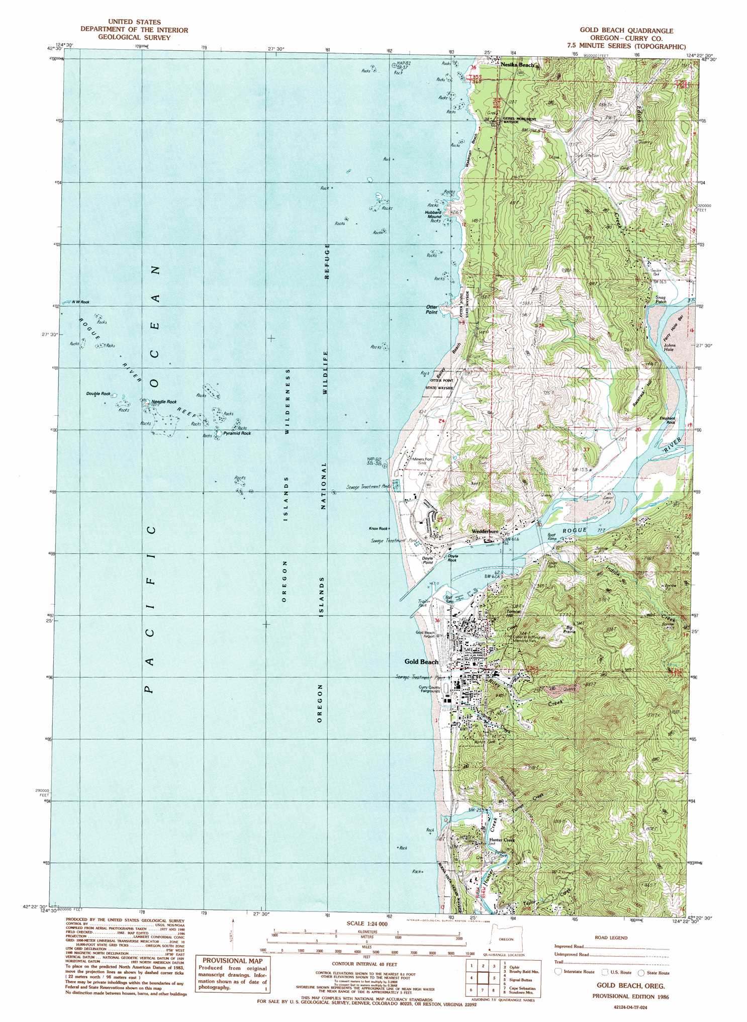
Gold Beach Topo Map Oregon
To zoom in, hover over the map of Gold Beach
USGS Topo Quad 42124d4 - 1:24,000 scale
| Topo Map Name: | Gold Beach |
| USGS Topo Quad ID: | 42124d4 |
| Print Size: | ca. 21 1/4" wide x 27" high |
| Southeast Coordinates: | 42.375° N latitude / 124.375° W longitude |
| Map Center Coordinates: | 42.4375° N latitude / 124.4375° W longitude |
| U.S. State: | OR |
| Filename: | o42124d4.jpg |
| Download Map JPG Image: | Gold Beach topo map 1:24,000 scale |
| Map Type: | Topographic |
| Topo Series: | 7.5´ |
| Map Scale: | 1:24,000 |
| Source of Map Images: | United States Geological Survey (USGS) |
| Alternate Map Versions: |
Gold Beach OR 1986, updated 1986 Download PDF Buy paper map Gold Beach OR 1986, updated 1986 Download PDF Buy paper map Gold Beach OR 2011 Download PDF Buy paper map Gold Beach OR 2014 Download PDF Buy paper map |
| FStopo: | US Forest Service topo Gold Beach is available: Download FStopo PDF Download FStopo TIF |
1:24,000 Topo Quads surrounding Gold Beach
Port Orford |
Father Mountain |
Ophir Mountain |
||
Ophir |
Brushy Bald Mountain |
Soldier Camp Mountain |
||
Gold Beach |
Signal Buttes |
Quosatana Butte |
||
Cape Sebastian |
Sundown Mountain |
Collier Butte |
||
Mack Point |
Carpenterville |
Bosley Butte |
> Back to 42124a1 at 1:100,000 scale
> Back to 42124a1 at 1:250,000 scale
> Back to U.S. Topo Maps home
Gold Beach topo map: Gazetteer
Gold Beach: Airports
Gold Beach Municipal Airport elevation 10m 32′Gold Beach: Areas
Big Prairie elevation 205m 672′Gold Beach: Bars
Doyle Rock elevation 4m 13′Elephant Rock elevation 11m 36′
Ferry Hole Bar elevation 6m 19′
Rogue River Reef elevation 0m 0′
Gold Beach: Beaches
Agate Beach elevation 0m 0′Barley Beach elevation 11m 36′
Wakeman Beach elevation 4m 13′
Gold Beach: Bends
Snag Patch elevation 6m 19′Gold Beach: Capes
Doyle Point elevation 27m 88′Otter Point elevation 0m 0′
Gold Beach: Channels
Johns Hole elevation 3m 9′Gold Beach: Islands
Double Rock elevation 12m 39′Knox Rock elevation 0m 0′
Needle Rock elevation 3m 9′
Needles elevation 0m 0′
Northwest Rock elevation 0m 0′
Pyramid Rock elevation 0m 0′
Gold Beach: Parks
Buena Vista State Park elevation 9m 29′Collier H Buffington Memorial Park elevation 22m 72′
Geisel Monument State Park elevation 28m 91′
Otter Point State Park elevation 29m 95′
Pocket Park elevation 17m 55′
South Beach Park elevation 11m 36′
Gold Beach: Populated Places
Gold Beach elevation 15m 49′Hunter Creek elevation 20m 65′
Knoxville (historical) elevation 26m 85′
Wedderburn elevation 12m 39′
Gold Beach: Post Offices
Gold Beach Post Office elevation 15m 49′Wedderburn Post Office elevation 12m 39′
Gold Beach: Streams
Antone Creek elevation 1m 3′Cummins Creek elevation 12m 39′
Cunniff Creek elevation 3m 9′
Dean Creek elevation 7m 22′
East Fork Cunniff Creek elevation 49m 160′
Edson Creek elevation 9m 29′
Flood Creek elevation 12m 39′
Hunter Creek elevation 0m 0′
Indian Creek elevation 5m 16′
Krambeal Creek elevation 13m 42′
Lynch Creek elevation 66m 216′
Middle Fork Riley Creek elevation 43m 141′
Miller Creek elevation 22m 72′
North Fork Riley Creek elevation 30m 98′
Riley Creek elevation 6m 19′
Rogue River elevation 0m 0′
Saunders Creek elevation 7m 22′
Scott Creek elevation 11m 36′
South Fork Riley Creek elevation 50m 164′
Turner Creek elevation 3m 9′
West Fork Cunniff Creek elevation 2m 6′
Gold Beach: Summits
Hubbard Mound elevation 45m 147′Racetrack Hill elevation 95m 311′
Tomcat Hill elevation 115m 377′
Gold Beach digital topo map on disk
Buy this Gold Beach topo map showing relief, roads, GPS coordinates and other geographical features, as a high-resolution digital map file on DVD: