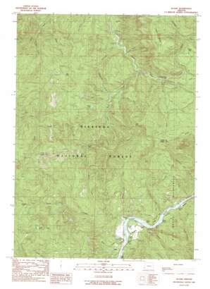
Illahe Topo Map Oregon
To zoom in, hover over the map of Illahe
USGS Topo Quad 42124f1 - 1:24,000 scale
| Topo Map Name: | Illahe |
| USGS Topo Quad ID: | 42124f1 |
| Print Size: | ca. 21 1/4" wide x 27" high |
| Southeast Coordinates: | 42.625° N latitude / 124° W longitude |
| Map Center Coordinates: | 42.6875° N latitude / 124.0625° W longitude |
| U.S. State: | OR |
| Filename: | o42124f1.jpg |
| Download Map JPG Image: | Illahe topo map 1:24,000 scale |
| Map Type: | Topographic |
| Topo Series: | 7.5´ |
| Map Scale: | 1:24,000 |
| Source of Map Images: | United States Geological Survey (USGS) |
| Alternate Map Versions: |
Illahe OR 1989, updated 1989 Download PDF Buy paper map Illahe OR 1998, updated 2001 Download PDF Buy paper map Illahe OR 2011 Download PDF Buy paper map Illahe OR 2014 Download PDF Buy paper map |
| FStopo: | US Forest Service topo Illahe is available: Download FStopo PDF Download FStopo TIF |
1:24,000 Topo Quads surrounding Illahe
> Back to 42124e1 at 1:100,000 scale
> Back to 42124a1 at 1:250,000 scale
> Back to U.S. Topo Maps home
Illahe topo map: Gazetteer
Illahe: Bars
Foster Bar elevation 51m 167′Illahe: Bends
Big Bend elevation 82m 269′Illahe: Channels
Brewery Hole elevation 51m 167′Illahe: Falls
Coquille River Falls elevation 410m 1345′Illahe: Forests
Coquille River Falls Natural Area elevation 418m 1371′Port Orford Cedar Experimental Forest elevation 111m 364′
Illahe: Gaps
Agness Pass elevation 719m 2358′Illahe: Islands
Burnt Rock elevation 53m 173′Illahe: Lakes
Azalea Lake elevation 549m 1801′Dry Lake elevation 976m 3202′
Foster Pond elevation 862m 2828′
Southard Lake elevation 870m 2854′
Sru Lake elevation 682m 2237′
Illahe: Mines
Independence Mine elevation 111m 364′Illahe: Populated Places
Illahe elevation 109m 357′Illahe: Post Offices
Illahe Post Office (historical) elevation 109m 357′Illahe: Rapids
Billings Rapids elevation 51m 167′Billings Rapids elevation 51m 167′
Burnt Rapids elevation 53m 173′
Foster Rapids elevation 50m 164′
Illahe Riffle elevation 45m 147′
Payton Riffle elevation 55m 180′
Watson Riffle elevation 52m 170′
Illahe: Reservoirs
Dads Lake elevation 393m 1289′Illahe: Streams
Anderson Creek elevation 244m 800′Bear Creek elevation 625m 2050′
Billings Creek elevation 56m 183′
Billys Creek elevation 66m 216′
Chrome Creek elevation 813m 2667′
Crater Creek elevation 352m 1154′
Dans Creek elevation 54m 177′
Doerr Creek elevation 117m 383′
Drowned Out Creek elevation 373m 1223′
East Fork Sru Creek elevation 587m 1925′
Fall Creek elevation 262m 859′
Fives Creek elevation 423m 1387′
Flea Creek elevation 88m 288′
Flora Dell Creek elevation 86m 282′
Foster Creek elevation 50m 164′
Hicks Creek elevation 83m 272′
Hosposki Creek elevation 259m 849′
Kickel Creek elevation 392m 1286′
Lake Creek elevation 362m 1187′
Lockhart Creek elevation 627m 2057′
Manganese Creek elevation 353m 1158′
Nickel Creek elevation 344m 1128′
North Fork Foster Creek elevation 102m 334′
North Fork Rock Creek elevation 651m 2135′
North Fork Shale Creek elevation 351m 1151′
Rock Creek elevation 290m 951′
Sand Creek elevation 418m 1371′
Slide Creek elevation 55m 180′
South Fork Shale Creek elevation 363m 1190′
Sru Creek elevation 356m 1167′
Two-Bit Creek elevation 415m 1361′
Watson Creek elevation 56m 183′
West Fork Sru Creek elevation 587m 1925′
Yellow Jacket Creek elevation 283m 928′
Illahe: Summits
Bald Knob elevation 1101m 3612′Illahe: Trails
Mountain Wells Trail elevation 996m 3267′Illahe digital topo map on disk
Buy this Illahe topo map showing relief, roads, GPS coordinates and other geographical features, as a high-resolution digital map file on DVD:


