China Flat Topo Map Oregon
To zoom in, hover over the map of China Flat
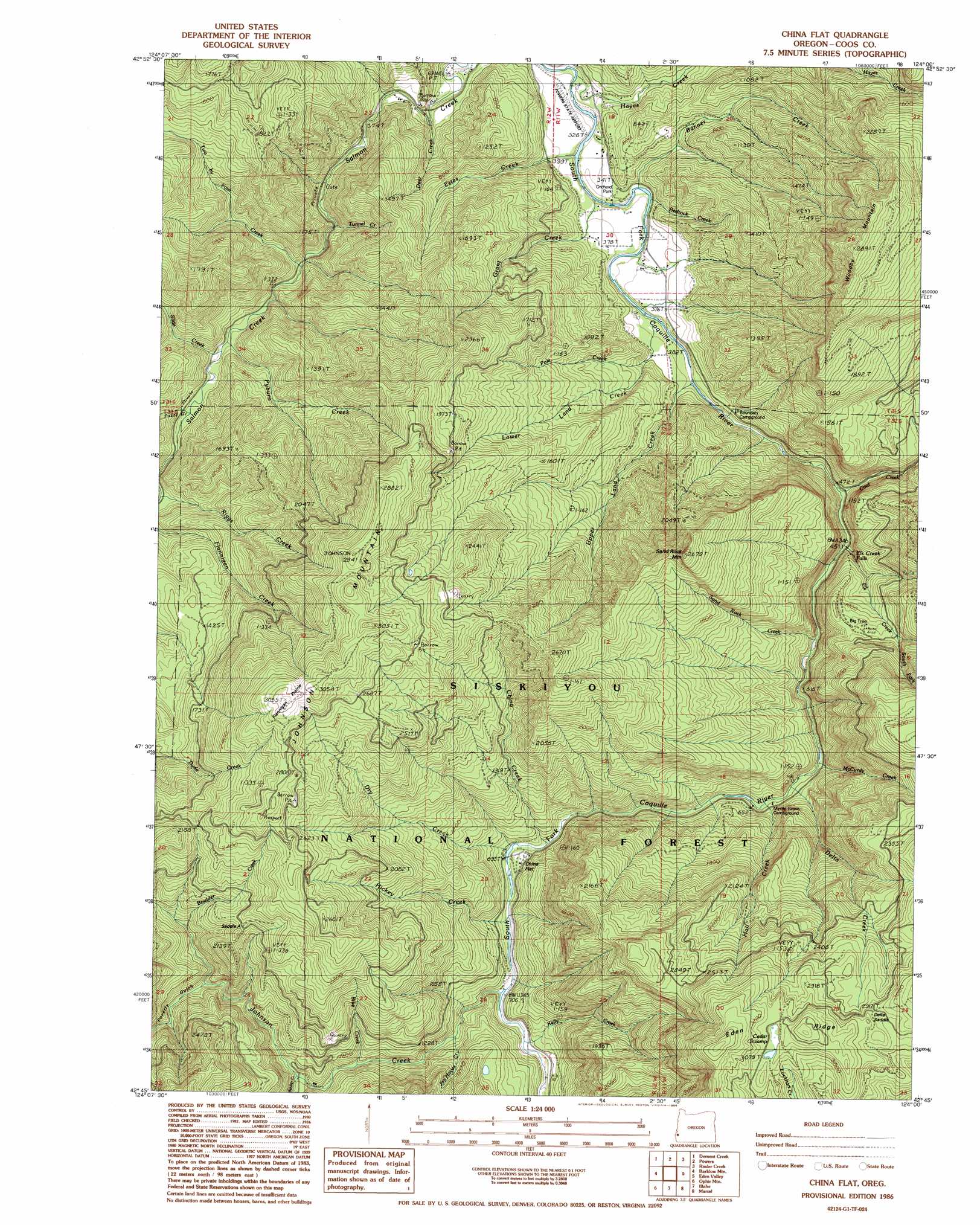
USGS Topo Quad 42124g1 - 1:24,000 scale
| Topo Map Name: | China Flat |
| USGS Topo Quad ID: | 42124g1 |
| Print Size: | ca. 21 1/4" wide x 27" high |
| Southeast Coordinates: | 42.75° N latitude / 124° W longitude |
| Map Center Coordinates: | 42.8125° N latitude / 124.0625° W longitude |
| U.S. State: | OR |
| Filename: | o42124g1.jpg |
| Download Map JPG Image: | China Flat topo map 1:24,000 scale |
| Map Type: | Topographic |
| Topo Series: | 7.5´ |
| Map Scale: | 1:24,000 |
| Source of Map Images: | United States Geological Survey (USGS) |
| Alternate Map Versions: |
China Flat OR 1986, updated 1986 Download PDF Buy paper map China Flat OR 1996, updated 1999 Download PDF Buy paper map China Flat OR 2011 Download PDF Buy paper map China Flat OR 2014 Download PDF Buy paper map |
| FStopo: | US Forest Service topo China Flat is available: Download FStopo PDF Download FStopo TIF |
1:24,000 Topo Quads surrounding China Flat
Bill Peak |
Myrtle Point |
Bridge |
Remote |
Kenyon Mountain |
Calf Ranch Mountain |
Dement Creek |
Powers |
Rasler Creek |
Bone Mountain |
Mount Butler |
Barklow Mountain |
China Flat |
Eden Ridge Valley |
Mount Bolivar |
Father Mountain |
Ophir Mountain |
Illahe |
Marial |
Kelsey Peak |
Brushy Bald Mountain |
Soldier Camp Mountain |
Agness |
Brandy Peak |
Hobson Horn |
> Back to 42124e1 at 1:100,000 scale
> Back to 42124a1 at 1:250,000 scale
> Back to U.S. Topo Maps home
China Flat topo map: Gazetteer
China Flat: Airports
Powers State Airport elevation 242m 793′China Flat: Falls
Elk Creek Falls elevation 148m 485′China Flat: Flats
China Flat elevation 362m 1187′Flannigan Prairie elevation 809m 2654′
China Flat: Gaps
Saddle A elevation 604m 1981′China Flat: Parks
Boundary Picnic Ground elevation 119m 390′Powers City Park elevation 101m 331′
China Flat: Post Offices
Rural Post Office (historical) elevation 100m 328′China Flat: Streams
Bedrock Creek elevation 91m 298′Blue Creek elevation 289m 948′
Bonner Creek elevation 91m 298′
Boulder Creek elevation 382m 1253′
China Creek elevation 208m 682′
Coal Creek elevation 137m 449′
Deer Creek elevation 110m 360′
Delta Creek elevation 177m 580′
Dry Creek elevation 207m 679′
Elk Creek elevation 144m 472′
Estes Creek elevation 83m 272′
Grant Creek elevation 100m 328′
Gurkin Creek elevation 277m 908′
Hall Creek elevation 181m 593′
Hayes Creek elevation 77m 252′
Hickey Creek elevation 207m 679′
Jim Hayes Creek elevation 265m 869′
Johnson Creek elevation 218m 715′
Kelly Creek elevation 258m 846′
Laird Creek elevation 406m 1332′
Lower Land Creek elevation 95m 311′
McCurdy Creek elevation 172m 564′
North Fork Elk Creek elevation 233m 764′
Pole Creek elevation 130m 426′
Pyburn Creek elevation 159m 521′
Ragsdale Creek elevation 417m 1368′
Sand Rock Creek elevation 154m 505′
Slide Creek elevation 159m 521′
South Fork Elk Creek elevation 338m 1108′
Sucker Creek elevation 316m 1036′
Tunnel Creek elevation 124m 406′
Two by Four Creek elevation 138m 452′
Upper Land Creek elevation 103m 337′
Waterpipe Creek elevation 130m 426′
Whitewash Creek elevation 100m 328′
China Flat: Summits
Johnson Mountain elevation 929m 3047′Sand Rock Mountain elevation 791m 2595′
Woodby Mountain elevation 859m 2818′
China Flat: Swamps
Cedar Swamp elevation 946m 3103′China Flat: Valleys
Fuzzy Gulch elevation 174m 570′Poverty Gulch elevation 407m 1335′
China Flat digital topo map on disk
Buy this China Flat topo map showing relief, roads, GPS coordinates and other geographical features, as a high-resolution digital map file on DVD: