Sixes Topo Map Oregon
To zoom in, hover over the map of Sixes
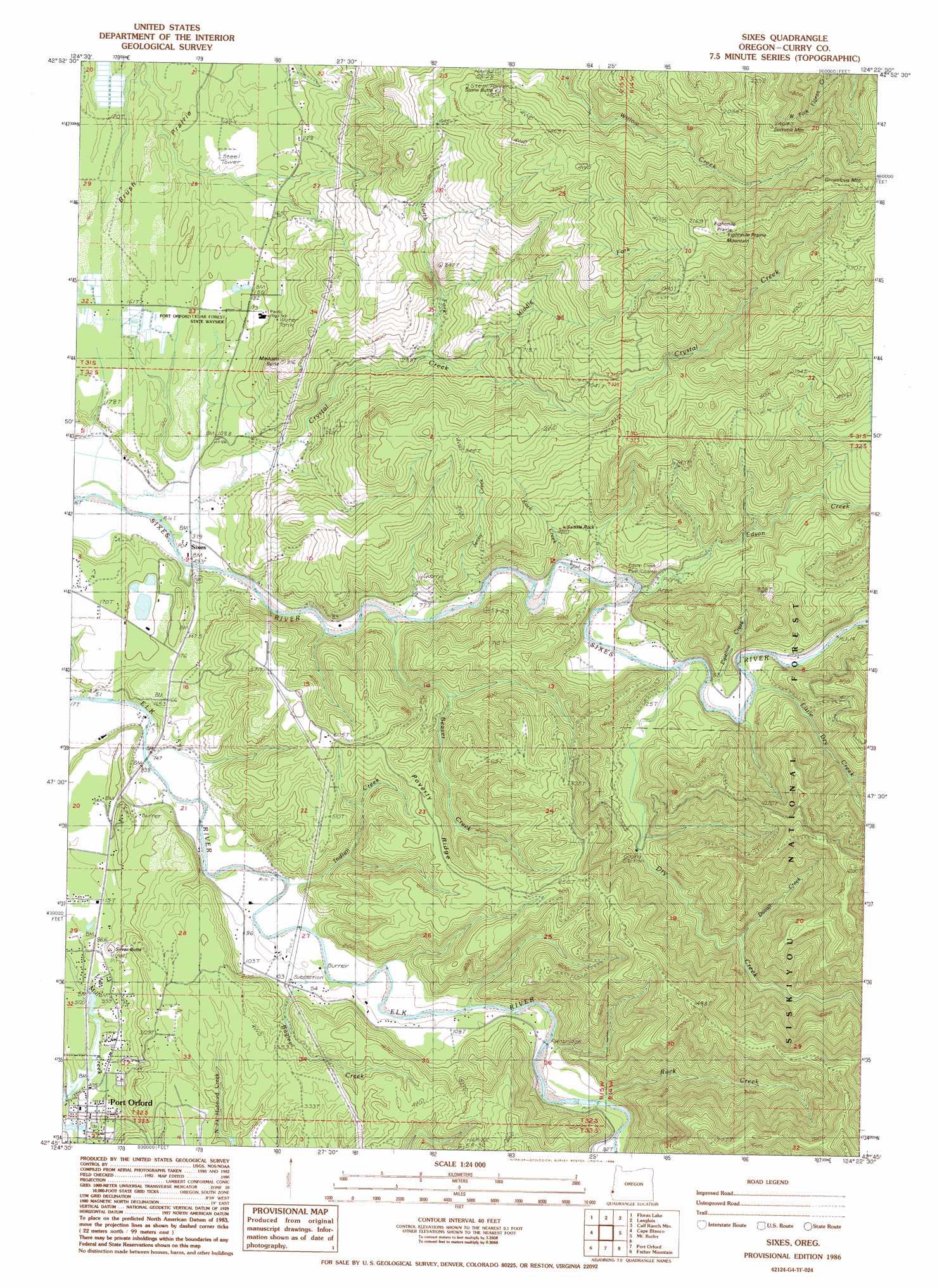
USGS Topo Quad 42124g4 - 1:24,000 scale
| Topo Map Name: | Sixes |
| USGS Topo Quad ID: | 42124g4 |
| Print Size: | ca. 21 1/4" wide x 27" high |
| Southeast Coordinates: | 42.75° N latitude / 124.375° W longitude |
| Map Center Coordinates: | 42.8125° N latitude / 124.4375° W longitude |
| U.S. State: | OR |
| Filename: | o42124g4.jpg |
| Download Map JPG Image: | Sixes topo map 1:24,000 scale |
| Map Type: | Topographic |
| Topo Series: | 7.5´ |
| Map Scale: | 1:24,000 |
| Source of Map Images: | United States Geological Survey (USGS) |
| Alternate Map Versions: |
Sixes OR 1986, updated 1986 Download PDF Buy paper map Sixes OR 1996, updated 1999 Download PDF Buy paper map Sixes OR 2011 Download PDF Buy paper map Sixes OR 2014 Download PDF Buy paper map |
| FStopo: | US Forest Service topo Sixes is available: Download FStopo PDF Download FStopo TIF |
1:24,000 Topo Quads surrounding Sixes
Bandon |
Bill Peak |
Myrtle Point |
||
Floras Lake |
Langlois |
Calf Ranch Mountain |
Dement Creek |
|
Cape Blanco |
Sixes |
Mount Butler |
Barklow Mountain |
|
Port Orford |
Father Mountain |
Ophir Mountain |
||
Ophir |
Brushy Bald Mountain |
Soldier Camp Mountain |
> Back to 42124e1 at 1:100,000 scale
> Back to 42124a1 at 1:250,000 scale
> Back to U.S. Topo Maps home
Sixes topo map: Gazetteer
Sixes: Areas
Brush Prairie elevation 28m 91′Eightmile Prairie elevation 713m 2339′
Sixes: Parks
Edson County Park elevation 22m 72′Port Orford Cedar Forest State Park elevation 50m 164′
Sixes: Pillars
Saddle Rock elevation 118m 387′Sixes: Populated Places
Sixes elevation 7m 22′Sixes: Post Offices
Sixes Post Office elevation 7m 22′Sixes: Reservoirs
Marsh Log Pond elevation 23m 75′Richman Reservoir elevation 29m 95′
Sixes: Ridges
Poverty Ridge elevation 189m 620′Sixes: Streams
Bagley Creek elevation 27m 88′Beaver Creek elevation 10m 32′
Bull Creek elevation 100m 328′
Crystal Creek elevation 7m 22′
Dry Creek elevation 24m 78′
Duvall Creek elevation 48m 157′
Edson Creek elevation 13m 42′
Indian Creek elevation 14m 45′
Jenny Creek elevation 18m 59′
Koch Creek elevation 13m 42′
Little Dry Creek elevation 20m 65′
Madden Creek elevation 28m 91′
Middle Fork Crystal Creek elevation 127m 416′
North Fork Crystal Creek elevation 66m 216′
Pipeline Creek elevation 42m 137′
Price Creek elevation 11m 36′
Rock Creek elevation 29m 95′
Silver Butte Creek elevation 25m 82′
Small Creek elevation 22m 72′
Summers Creek elevation 10m 32′
Sixes: Summits
Eightmile Prairie Mountain elevation 715m 2345′Grouslous Mountain elevation 757m 2483′
Madden Butte elevation 228m 748′
Silver Butte elevation 60m 196′
Stone Butte elevation 422m 1384′
Summit Mountain elevation 712m 2335′
Sixes: Trails
Grassy Knob Trail elevation 404m 1325′Sixes digital topo map on disk
Buy this Sixes topo map showing relief, roads, GPS coordinates and other geographical features, as a high-resolution digital map file on DVD: