Calf Ranch Mountain Topo Map Oregon
To zoom in, hover over the map of Calf Ranch Mountain
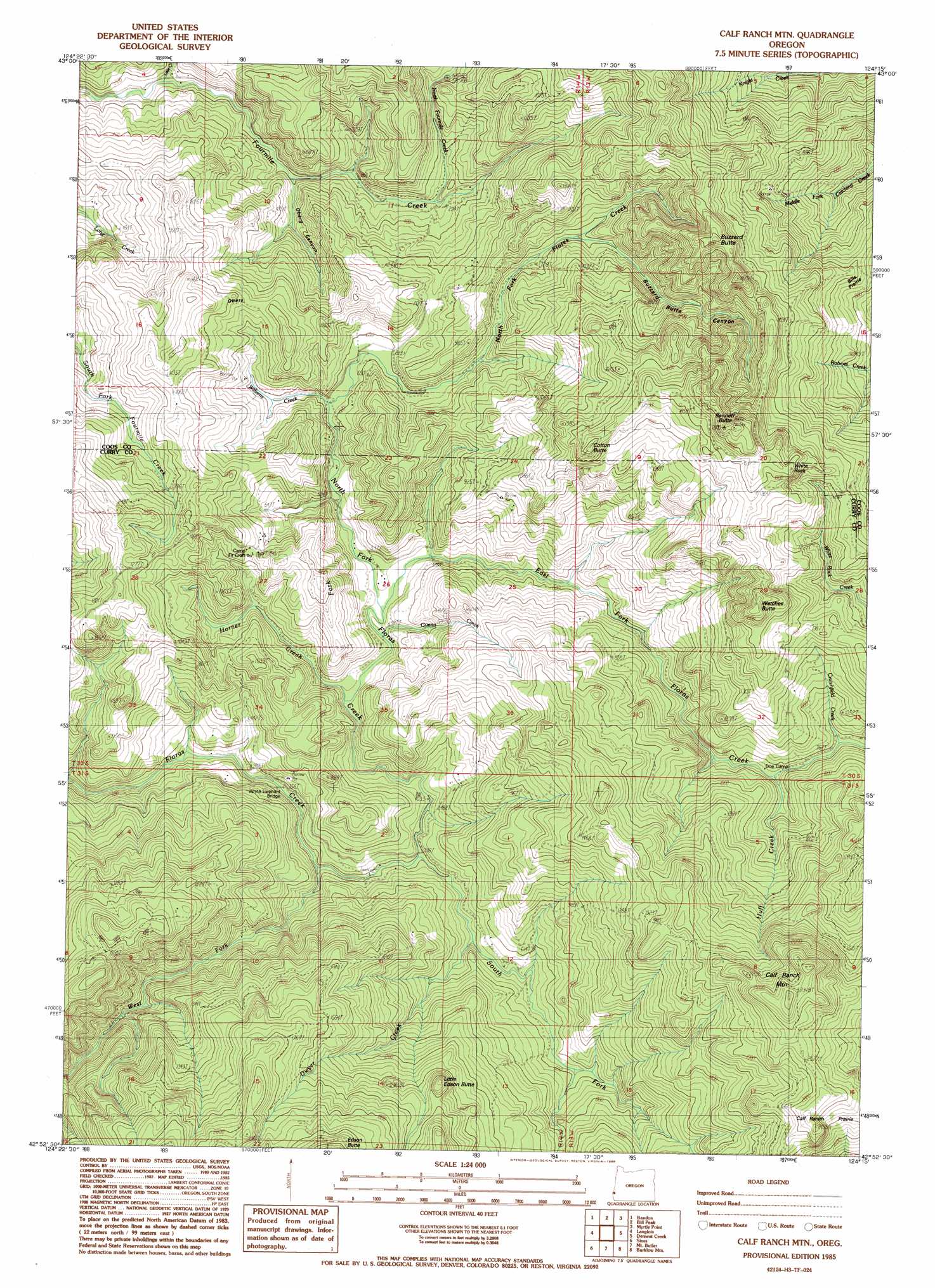
USGS Topo Quad 42124h3 - 1:24,000 scale
| Topo Map Name: | Calf Ranch Mountain |
| USGS Topo Quad ID: | 42124h3 |
| Print Size: | ca. 21 1/4" wide x 27" high |
| Southeast Coordinates: | 42.875° N latitude / 124.25° W longitude |
| Map Center Coordinates: | 42.9375° N latitude / 124.3125° W longitude |
| U.S. State: | OR |
| Filename: | o42124h3.jpg |
| Download Map JPG Image: | Calf Ranch Mountain topo map 1:24,000 scale |
| Map Type: | Topographic |
| Topo Series: | 7.5´ |
| Map Scale: | 1:24,000 |
| Source of Map Images: | United States Geological Survey (USGS) |
| Alternate Map Versions: |
Calf Ranch Mtn OR 1985, updated 1986 Download PDF Buy paper map Calf Ranch Mountain OR 1996, updated 1999 Download PDF Buy paper map Calf Ranch Mountain OR 2011 Download PDF Buy paper map Calf Ranch Mountain OR 2014 Download PDF Buy paper map |
| FStopo: | US Forest Service topo Calf Ranch Mountain is available: Download FStopo PDF Download FStopo TIF |
1:24,000 Topo Quads surrounding Calf Ranch Mountain
Bullards |
Riverton |
Coquille |
Mckinley |
|
Bandon |
Bill Peak |
Myrtle Point |
Bridge |
|
Floras Lake |
Langlois |
Calf Ranch Mountain |
Dement Creek |
Powers |
Cape Blanco |
Sixes |
Mount Butler |
Barklow Mountain |
China Flat |
Port Orford |
Father Mountain |
Ophir Mountain |
Illahe |
> Back to 42124e1 at 1:100,000 scale
> Back to 42124a1 at 1:250,000 scale
> Back to U.S. Topo Maps home
Calf Ranch Mountain topo map: Gazetteer
Calf Ranch Mountain: Bridges
White Elephant Bridge elevation 101m 331′Calf Ranch Mountain: Flats
Calf Ranch Prairie elevation 506m 1660′Calf Ranch Mountain: Pillars
White Rock elevation 559m 1833′Calf Ranch Mountain: Post Offices
Bennett Post Office (historical) elevation 426m 1397′Hare Post Office (historical) elevation 376m 1233′
Triangle Post Office (historical) elevation 191m 626′
Calf Ranch Mountain: Streams
Crutchfield Creek elevation 234m 767′Dwyer Creek elevation 149m 488′
East Fork Floras Creek elevation 146m 479′
Guerin Creek elevation 150m 492′
Horner Creek elevation 148m 485′
Huff Creek elevation 218m 715′
Little Creek elevation 47m 154′
North Fork Floras Creek elevation 126m 413′
North Fourmile Creek elevation 89m 291′
South Fork Floras Creek elevation 127m 416′
West Fork Floras Creek elevation 145m 475′
Williams Creek elevation 169m 554′
Calf Ranch Mountain: Summits
Bennett Butte elevation 639m 2096′Buzzard Butte elevation 547m 1794′
Calf Ranch Mountain elevation 730m 2395′
Cotton Butte elevation 555m 1820′
Little Edson Butte elevation 511m 1676′
Watches Butte elevation 576m 1889′
Calf Ranch Mountain: Valleys
Buzzard Butte Canyon elevation 260m 853′Oberg Canyon elevation 58m 190′
Calf Ranch Mountain digital topo map on disk
Buy this Calf Ranch Mountain topo map showing relief, roads, GPS coordinates and other geographical features, as a high-resolution digital map file on DVD: