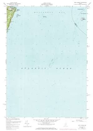
New Harbor Topo Map Maine
To zoom in, hover over the map of New Harbor
USGS Topo Quad 43069g4 - 1:24,000 scale
| Topo Map Name: | New Harbor |
| USGS Topo Quad ID: | 43069g4 |
| Print Size: | ca. 21 1/4" wide x 27" high |
| Southeast Coordinates: | 43.75° N latitude / 69.375° W longitude |
| Map Center Coordinates: | 43.8125° N latitude / 69.4375° W longitude |
| U.S. State: | ME |
| Filename: | o43069g4.jpg |
| Download Map JPG Image: | New Harbor topo map 1:24,000 scale |
| Map Type: | Topographic |
| Topo Series: | 7.5´ |
| Map Scale: | 1:24,000 |
| Source of Map Images: | United States Geological Survey (USGS) |
| Alternate Map Versions: |
New Harbor ME 1955, updated 1958 Download PDF Buy paper map New Harbor ME 1955, updated 1968 Download PDF Buy paper map New Harbor ME 1955, updated 1974 Download PDF Buy paper map New Harbor ME 1973, updated 1974 Download PDF Buy paper map New Harbor ME 2011 Download PDF Buy paper map New Harbor ME 2014 Download PDF Buy paper map |
1:24,000 Topo Quads surrounding New Harbor
Wiscasset |
Damariscotta |
Waldoboro West |
Waldoboro East |
Thomaston |
Westport |
Bristol |
Louds Island |
Friendship |
Tenants Harbor |
Boothbay Harbor |
Pemaquid Point |
New Harbor |
Monhegan |
|
> Back to 43069e1 at 1:100,000 scale
> Back to 43068a1 at 1:250,000 scale
> Back to U.S. Topo Maps home
New Harbor topo map: Gazetteer
New Harbor: Bars
Egg Rock North Ledge elevation 0m 0′Egg Rock South Ledge elevation 0m 0′
Moser Ledge elevation 0m 0′
New Harbor Dry Ledges elevation 0m 0′
New Harbor Sunken Ledges elevation 0m 0′
Pumpkin Cove Ledge elevation 0m 0′
South Ledge elevation 0m 0′
New Harbor: Bays
Back Cove elevation 9m 29′New Harbor elevation 0m 0′
Pumpkin Cove elevation 0m 0′
New Harbor: Islands
Eastern Egg Rock elevation 6m 19′Little Island elevation 5m 16′
New Harbor: Parks
Samoset Memorial elevation 1m 3′New Harbor: Populated Places
Yellow Head elevation 7m 22′New Harbor: Summits
Lookout Hill elevation 33m 108′New Harbor digital topo map on disk
Buy this New Harbor topo map showing relief, roads, GPS coordinates and other geographical features, as a high-resolution digital map file on DVD:
Maine, New Hampshire, Rhode Island & Eastern Massachusetts
Buy digital topo maps: Maine, New Hampshire, Rhode Island & Eastern Massachusetts


