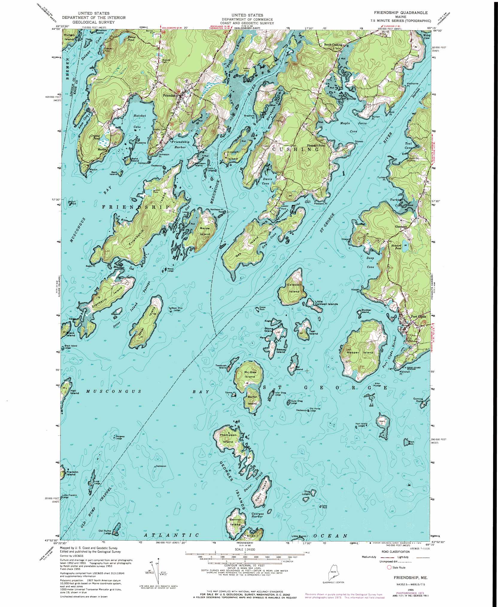
Friendship Topo Map Maine
To zoom in, hover over the map of Friendship
USGS Topo Quad 43069h3 - 1:24,000 scale
| Topo Map Name: | Friendship |
| USGS Topo Quad ID: | 43069h3 |
| Print Size: | ca. 21 1/4" wide x 27" high |
| Southeast Coordinates: | 43.875° N latitude / 69.25° W longitude |
| Map Center Coordinates: | 43.9375° N latitude / 69.3125° W longitude |
| U.S. State: | ME |
| Filename: | o43069h3.jpg |
| Download Map JPG Image: | Friendship topo map 1:24,000 scale |
| Map Type: | Topographic |
| Topo Series: | 7.5´ |
| Map Scale: | 1:24,000 |
| Source of Map Images: | United States Geological Survey (USGS) |
| Alternate Map Versions: |
Friendship ME 1955, updated 1959 Download PDF Buy paper map Friendship ME 1955, updated 1970 Download PDF Buy paper map Friendship ME 1955, updated 1974 Download PDF Buy paper map Friendship ME 2011 Download PDF Buy paper map Friendship ME 2014 Download PDF Buy paper map |
1:24,000 Topo Quads surrounding Friendship
North Whitefield |
Jefferson |
Union |
West Rockport |
Camden |
Damariscotta |
Waldoboro West |
Waldoboro East |
Thomaston |
Rockland |
Bristol |
Louds Island |
Friendship |
Tenants Harbor |
Hewett Island |
Pemaquid Point |
New Harbor |
Monhegan |
||
> Back to 43069e1 at 1:100,000 scale
> Back to 43068a1 at 1:250,000 scale
> Back to U.S. Topo Maps home
Friendship topo map: Gazetteer
Friendship: Bars
Allen Ledge elevation 0m 0′Bay Cove Ledge elevation 0m 0′
Beyer Ship Ledge elevation 1m 3′
Black Island Ledge elevation 0m 0′
Carey Rock elevation 0m 0′
Channel Rock elevation 0m 0′
Crotch Island Ledges elevation 0m 0′
Davis Shoal elevation 0m 0′
Gangway Ledge elevation 0m 0′
Gay Cove Ledge elevation 0m 0′
Gig Rock elevation 0m 0′
Goose Rock Ledge elevation 0m 0′
Griffin Ledge elevation 0m 0′
Gull Rock elevation 1m 3′
Hart Island Ledges elevation 0m 0′
Henderson Ledge elevation 0m 0′
Inner Shag Ledge elevation 0m 0′
Jenks Ledge elevation 0m 0′
Kelp Ledges elevation 0m 0′
Long Ledge elevation 3m 9′
Marshall Ledge elevation 0m 0′
Morse Ledge elevation 0m 0′
Murray Ledge elevation 0m 0′
Northeast Point Reef elevation 0m 0′
Old Cilley Ledge elevation 0m 0′
Old Horse Ledge elevation 0m 0′
Old Hump Ledge elevation 6m 19′
Otter Island Ledge elevation 0m 0′
Outer Shag Ledge elevation 0m 0′
Shag Ledges elevation 1m 3′
The Kegs elevation 0m 0′
The Sisters elevation 0m 0′
Thompson Rock elevation 0m 0′
Friendship: Bays
Davis Cove elevation 0m 0′Deep Cove elevation 0m 0′
Delano Cove elevation 0m 0′
Floods Cove elevation 0m 0′
Friendship Harbor elevation 0m 0′
Gay Cove elevation 0m 0′
Georges Harbor elevation 0m 0′
Hatchet Cove elevation 0m 0′
Hornbarn Cove elevation 0m 0′
Maple Juice Cove elevation 0m 0′
Port Clyde Harbor elevation 0m 0′
Teel Cove elevation 0m 0′
Turkey Cove elevation 0m 0′
Wiley Cove elevation 0m 0′
Friendship: Capes
Bird Point elevation 1m 3′Bradford Point elevation 1m 3′
Burton Point elevation 0m 0′
Hathorne Point elevation 3m 9′
Howard Point elevation 2m 6′
Hupper Point elevation 1m 3′
Jameson Point elevation 9m 29′
Marshall Point elevation 1m 3′
Martin Point elevation 6m 19′
Neds Point elevation 3m 9′
Pleasant Point elevation 5m 16′
Stones Point elevation 2m 6′
Turkey Point elevation 3m 9′
Friendship: Channels
Davis Strait elevation 0m 0′Old Hump Channel elevation 0m 0′
Otter Island Passage elevation 0m 0′
Friendship: Dams
Crystal Pond Dam elevation 5m 16′Forest Pond Dam elevation 20m 65′
Friendship: Guts
Lobster Gut elevation 0m 0′Minister Gut elevation 0m 0′
Pleasant Point Gut elevation 0m 0′
Friendship: Islands
Bar Island elevation 6m 19′Barter Island elevation 15m 49′
Benner Island elevation 6m 19′
Black Island elevation 10m 32′
Black Rock elevation 0m 0′
Blubber Island elevation 2m 6′
Caldwell Island elevation 25m 82′
Cedar Island elevation 6m 19′
Cranberry Island elevation 12m 39′
Crotch Island elevation 6m 19′
Davis Island elevation 8m 26′
Eagle Island elevation 4m 13′
Franklin Island elevation 9m 29′
Friendship Long Island elevation 28m 91′
Garrison Island elevation 5m 16′
Gay Island elevation 18m 59′
Goose Rock elevation 0m 0′
Hall Island elevation 7m 22′
Hart Island elevation 4m 13′
Hungry Island elevation 21m 68′
Hupper Island elevation 13m 42′
Little Caldwell Islands elevation 10m 32′
McGee Island elevation 11m 36′
Morse Island elevation 25m 82′
Nubbins elevation 0m 0′
Otter Island elevation 8m 26′
Ram Island elevation 5m 16′
Ram Island elevation 3m 9′
Sand Island elevation 7m 22′
Seavey Island elevation 3m 9′
Stone Island elevation 5m 16′
Teel Island elevation 13m 42′
Thompson Island elevation 16m 52′
Toms Island elevation 3m 9′
Twobush Island elevation 3m 9′
Friendship: Lakes
Howard Pond elevation 11m 36′Friendship: Populated Places
Friendship elevation 36m 118′Glenmere elevation 17m 55′
Martin elevation 7m 22′
Pleasant Point elevation 9m 29′
Port Clyde elevation 18m 59′
South Cushing elevation 6m 19′
Friendship: Reservoirs
Crystal Pond elevation 5m 16′Forest Pond elevation 20m 65′
Friendship: Streams
Back River elevation 0m 0′Meduncook River elevation 0m 0′
Saint George River elevation 0m 0′
Friendship digital topo map on disk
Buy this Friendship topo map showing relief, roads, GPS coordinates and other geographical features, as a high-resolution digital map file on DVD:
Maine, New Hampshire, Rhode Island & Eastern Massachusetts
Buy digital topo maps: Maine, New Hampshire, Rhode Island & Eastern Massachusetts