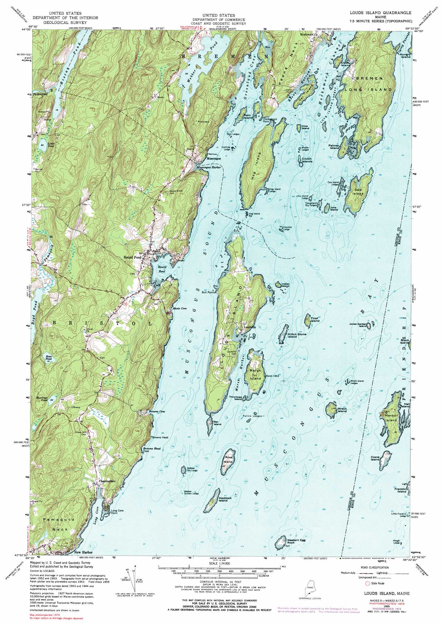
Louds Island Topo Map Maine
To zoom in, hover over the map of Louds Island
USGS Topo Quad 43069h4 - 1:24,000 scale
| Topo Map Name: | Louds Island |
| USGS Topo Quad ID: | 43069h4 |
| Print Size: | ca. 21 1/4" wide x 27" high |
| Southeast Coordinates: | 43.875° N latitude / 69.375° W longitude |
| Map Center Coordinates: | 43.9375° N latitude / 69.4375° W longitude |
| U.S. State: | ME |
| Filename: | o43069h4.jpg |
| Download Map JPG Image: | Louds Island topo map 1:24,000 scale |
| Map Type: | Topographic |
| Topo Series: | 7.5´ |
| Map Scale: | 1:24,000 |
| Source of Map Images: | United States Geological Survey (USGS) |
| Alternate Map Versions: |
Louds Island ME 1955, updated 1959 Download PDF Buy paper map Louds Island ME 1955, updated 1969 Download PDF Buy paper map Louds Island ME 1955, updated 1974 Download PDF Buy paper map Long Island ME 1955, updated 1985 Download PDF Buy paper map Louds Island ME 1955, updated 1985 Download PDF Buy paper map Louds Island ME 2011 Download PDF Buy paper map Louds Island ME 2014 Download PDF Buy paper map |
1:24,000 Topo Quads surrounding Louds Island
East Pittston |
North Whitefield |
Jefferson |
Union |
West Rockport |
Wiscasset |
Damariscotta |
Waldoboro West |
Waldoboro East |
Thomaston |
Westport |
Bristol |
Louds Island |
Friendship |
Tenants Harbor |
Boothbay Harbor |
Pemaquid Point |
New Harbor |
Monhegan |
|
> Back to 43069e1 at 1:100,000 scale
> Back to 43068a1 at 1:250,000 scale
> Back to U.S. Topo Maps home
Louds Island topo map: Gazetteer
Louds Island: Bars
Bar Island Ledge elevation 0m 0′Browns Head Ledge elevation 0m 0′
Coombs Ledge elevation 0m 0′
Cow Island Dry Ledges elevation 0m 0′
Cow Island Ledges elevation 0m 0′
Cow Island Sunken Ledges elevation 0m 0′
Devils Back elevation 0m 0′
Devils Elbow elevation 0m 0′
Devils Limb elevation 0m 0′
Garden Island South Ledge elevation 0m 0′
Haddock Island Kelp Ledge elevation 0m 0′
Haddock Island Ledge elevation 0m 0′
Halftide Ledge elevation 0m 0′
Harbor Island Rock elevation 0m 0′
Hog Island Bar elevation 0m 0′
Hog Island Ledge elevation 0m 0′
Hough Ledge elevation 0m 0′
Inner Ledge elevation 0m 0′
Jims Island Ledge elevation 0m 0′
Little Franklin Ledge elevation 2m 6′
Long Island Ledges elevation 0m 0′
Middle Ledges elevation 0m 0′
Poland North Ledge elevation 0m 0′
Poland South Ledge elevation 0m 0′
Polins East Ledge elevation 0m 0′
Polins Ledges elevation 0m 0′
Ram Ledges elevation 0m 0′
Round Rock elevation 0m 0′
Salt Pond Ledge elevation 0m 0′
Webber Dry Ledge elevation 0m 0′
Webber North Ledge elevation 0m 0′
Webber Sunken Ledge elevation 0m 0′
Wreck Island Ledges elevation 3m 9′
Louds Island: Bays
Browns Cove elevation 7m 22′Browns Head Cove elevation 3m 9′
Greenland Cove elevation 0m 0′
Long Cove elevation 0m 0′
Marsh Harbor elevation 0m 0′
Moxie Cove elevation 7m 22′
Muscongus Bay elevation 0m 0′
Muscongus Harbor elevation 0m 0′
Muscongus Sound elevation 0m 0′
Round Pond elevation 0m 0′
Louds Island: Benches
Poland Ledges elevation 0m 0′Louds Island: Capes
Bull Point elevation 0m 0′Hockomock Point elevation 0m 0′
Long Cove Point elevation 11m 36′
Pemaquid Neck elevation 28m 91′
Louds Island: Channels
Flying Passage elevation 0m 0′Hockomock Channel elevation 0m 0′
Keene Narrows elevation 3m 9′
Lower Narrows elevation 0m 0′
Lower Narrows elevation 0m 0′
Louds Island: Dams
New Harbor Pond Dam elevation 16m 52′Louds Island: Islands
Bar Island elevation 4m 13′Bremen Long Island elevation 39m 127′
Clam Island elevation 10m 32′
Cow Island elevation 15m 49′
Crane Island elevation 3m 9′
Crotch Islands elevation 0m 0′
Crow Island elevation 1m 3′
Haddock Island elevation 5m 16′
Harbor Island elevation 7m 22′
Hog Island elevation 27m 88′
Indian Island elevation 3m 9′
Jims Island elevation 3m 9′
Jones Garden Island elevation 2m 6′
Killick Stone Island elevation 3m 9′
Louds Island elevation 21m 68′
Marsh Island elevation 17m 55′
Oar Island elevation 9m 29′
Palmer Island elevation 9m 29′
Ram Island elevation 1m 3′
Ross Island elevation 3m 9′
Thief Island elevation 8m 26′
Thrumcap Island elevation 0m 0′
Western Egg Rock elevation 5m 16′
Wreck Corner elevation 12m 39′
Wreck Island elevation 12m 39′
Louds Island: Lakes
Boyd Pond elevation 10m 32′Hastings Pond elevation 37m 121′
Little Pond elevation 25m 82′
Ross Pond elevation 37m 121′
Webber Pond elevation 17m 55′
Louds Island: Parks
Duryea Morton Audubon Sanctuary elevation 4m 13′Rachael Carson Salt Pond Preserve elevation 4m 13′
Todd Wildlife Sanctuary elevation 21m 68′
Louds Island: Populated Places
Chamberlain elevation 3m 9′Loudville elevation 5m 16′
Muscongus elevation 7m 22′
New Harbor elevation 11m 36′
Round Pond elevation 15m 49′
Louds Island: Reservoirs
New Harbor Pond elevation 16m 52′Louds Island: Ridges
Keene Neck elevation 40m 131′Louds Island: Trails
Hockomock Nature Trail elevation 5m 16′Louds Island digital topo map on disk
Buy this Louds Island topo map showing relief, roads, GPS coordinates and other geographical features, as a high-resolution digital map file on DVD:
Maine, New Hampshire, Rhode Island & Eastern Massachusetts
Buy digital topo maps: Maine, New Hampshire, Rhode Island & Eastern Massachusetts