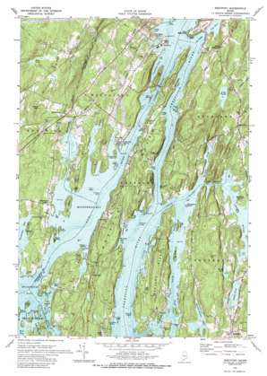
Westport Topo Map Maine
To zoom in, hover over the map of Westport
USGS Topo Quad 43069h6 - 1:24,000 scale
| Topo Map Name: | Westport |
| USGS Topo Quad ID: | 43069h6 |
| Print Size: | ca. 21 1/4" wide x 27" high |
| Southeast Coordinates: | 43.875° N latitude / 69.625° W longitude |
| Map Center Coordinates: | 43.9375° N latitude / 69.6875° W longitude |
| U.S. State: | ME |
| Filename: | o43069h6.jpg |
| Download Map JPG Image: | Westport topo map 1:24,000 scale |
| Map Type: | Topographic |
| Topo Series: | 7.5´ |
| Map Scale: | 1:24,000 |
| Source of Map Images: | United States Geological Survey (USGS) |
| Alternate Map Versions: |
Westport ME 1970, updated 1974 Download PDF Buy paper map Westport ME 1970, updated 1989 Download PDF Buy paper map Westport ME 2000, updated 2001 Download PDF Buy paper map Westport ME 2011 Download PDF Buy paper map Westport ME 2014 Download PDF Buy paper map |
1:24,000 Topo Quads surrounding Westport
> Back to 43069e1 at 1:100,000 scale
> Back to 43068a1 at 1:250,000 scale
> Back to U.S. Topo Maps home
Westport topo map: Gazetteer
Westport: Airports
Wiscasset Airport elevation 18m 59′Westport: Bars
Greenleaf Ledge elevation 0m 0′Halftide Rock elevation 0m 0′
Hodgdon Ledge elevation 0m 0′
Long Ledge elevation 0m 0′
Merrill Ledge elevation 0m 0′
Seal Rock elevation 0m 0′
Seal Rocks elevation 0m 0′
Shag Ledge elevation 0m 0′
Stover Ledge elevation 0m 0′
The Boilers elevation 0m 0′
Westport: Bays
Brookings Bay elevation 0m 0′Colby Cove elevation 0m 0′
Cushman Cove elevation 0m 0′
Fowle Cove elevation 0m 0′
Greenleaf Cove elevation 0m 0′
Hall Bay elevation 0m 0′
Heal Cove elevation 0m 0′
Hilton Cove elevation 0m 0′
Hockomock Bay elevation 0m 0′
McCarty Cove elevation 3m 9′
Merrill Cove elevation 1m 3′
Montsweag Bay elevation 0m 0′
Pea Cove elevation 0m 0′
Pottle Cove elevation 0m 0′
Rum Cove elevation 0m 0′
Tarbox Cove elevation 0m 0′
The Eddy elevation 0m 0′
Webber Cove elevation 0m 0′
Westport: Capes
Bailey Point elevation 1m 3′Bareneck Point elevation 0m 0′
Bartlett Point elevation 9m 29′
Birch Point elevation 2m 6′
Bluff Head elevation 17m 55′
Chewonki Neck elevation 23m 75′
Clough Point elevation 13m 42′
Cross Point elevation 6m 19′
Crow Point elevation 2m 6′
Cushman Point elevation 19m 62′
Doggard Point elevation 10m 32′
Fowle Point elevation 2m 6′
Hillton Point elevation 6m 19′
Hubbard Point elevation 18m 59′
North Point elevation 3m 9′
Pea Point elevation 13m 42′
Phipps Point elevation 5m 16′
Quarry Point elevation 18m 59′
Rocky Point elevation 3m 9′
White Point elevation 3m 9′
Willis Point elevation 12m 39′
Young Point elevation 6m 19′
Westport: Channels
Cowseagan Narrows elevation 0m 0′Lower Hell Gate elevation 0m 0′
Oven Mouth elevation 0m 0′
Westport: Dams
Adams Pond Dam elevation 16m 52′Hilton Pond Dam elevation 4m 13′
Montsweag Dam elevation 4m 13′
Westport: Guts
Back River elevation 0m 0′Westport: Islands
Bareneck Island elevation 5m 16′Barters Island elevation 41m 134′
Beal Island elevation 21m 68′
Berry Island elevation 10m 32′
Berry Island elevation 4m 13′
Castle Island elevation 9m 29′
Castle Rock elevation 1m 3′
Crow Island elevation 0m 0′
Davis Island elevation 17m 55′
Foxbird Island elevation 7m 22′
Gooseberry Island elevation 1m 3′
Harper Island elevation 2m 6′
Hodgdon Island elevation 9m 29′
Little Oak Island elevation 2m 6′
Merrow Island elevation 13m 42′
Miles Island elevation 13m 42′
Oak Island elevation 22m 72′
Pine Island elevation 14m 45′
Tibbet Island elevation 13m 42′
Tyler Islands elevation 4m 13′
Webber Island elevation 3m 9′
Westport Island elevation 27m 88′
Whites Island elevation 1m 3′
Westport: Lakes
Heal Pond elevation 0m 0′Knickerbocker Lakes elevation 5m 16′
Lily Pond elevation 15m 49′
Wiley Pond elevation 24m 78′
Wolf Pond elevation 38m 124′
Westport: Parks
Fort Edgecomb State Park elevation 0m 0′Harold B Clifford Playground elevation 33m 108′
Ovens Mouth Preserve elevation 29m 95′
Porter Preserve elevation 0m 0′
Singing Meadow Preserve elevation 10m 32′
Westport: Populated Places
Boothbay elevation 37m 121′Dover elevation 18m 59′
Edgecomb elevation 44m 144′
Fort Edgecomb elevation 9m 29′
Montsweag elevation 20m 65′
Murphys Corner elevation 13m 42′
North Edgecomb elevation 49m 160′
Oak Hill elevation 10m 32′
Trevett elevation 15m 49′
Westport elevation 31m 101′
Westport: Post Offices
Boothbay Post Office elevation 37m 121′Westport: Reservoirs
Adams Pond elevation 16m 52′Hilton Pond elevation 4m 13′
Montsweag Reservoir elevation 4m 13′
Westport: Ridges
Whaleback Ridge elevation 62m 203′Westport: Streams
Chewonki Creek elevation 0m 0′Cross River elevation 0m 0′
Montsweag Brook elevation 0m 0′
Parsons Creek elevation 5m 16′
Squam Creek elevation 0m 0′
Ward Brook elevation 1m 3′
Westport: Summits
Burleigh Hill elevation 22m 72′Cushman Hill elevation 45m 147′
Doggett Castle elevation 38m 124′
High Head elevation 44m 144′
Ozone Mountain elevation 58m 190′
Smith Hill elevation 72m 236′
Tyler Hill elevation 39m 127′
Westport digital topo map on disk
Buy this Westport topo map showing relief, roads, GPS coordinates and other geographical features, as a high-resolution digital map file on DVD:
Maine, New Hampshire, Rhode Island & Eastern Massachusetts
Buy digital topo maps: Maine, New Hampshire, Rhode Island & Eastern Massachusetts


