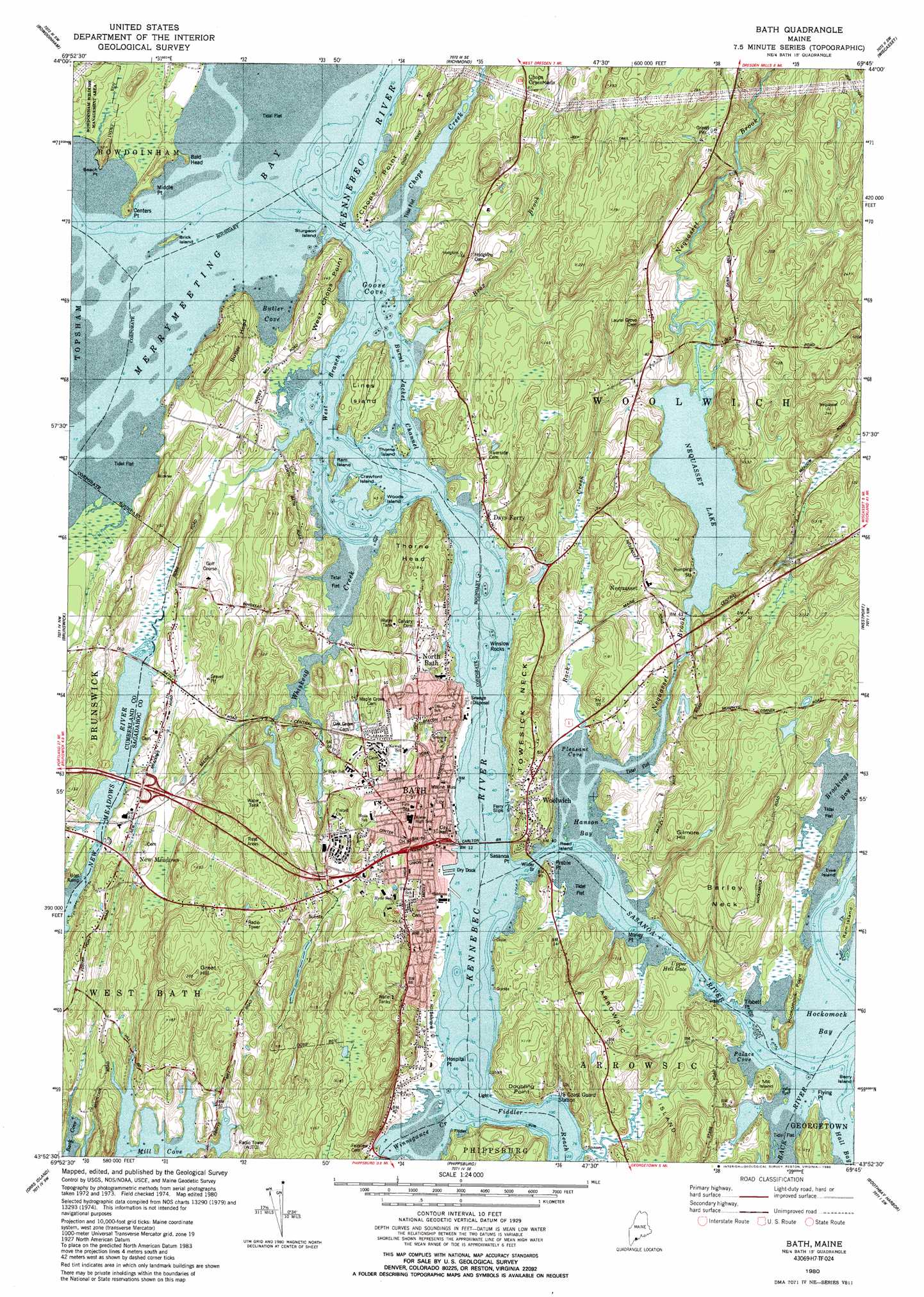
Bath Topo Map Maine
To zoom in, hover over the map of Bath
USGS Topo Quad 43069h7 - 1:24,000 scale
| Topo Map Name: | Bath |
| USGS Topo Quad ID: | 43069h7 |
| Print Size: | ca. 21 1/4" wide x 27" high |
| Southeast Coordinates: | 43.875° N latitude / 69.75° W longitude |
| Map Center Coordinates: | 43.9375° N latitude / 69.8125° W longitude |
| U.S. State: | ME |
| Filename: | o43069h7.jpg |
| Download Map JPG Image: | Bath topo map 1:24,000 scale |
| Map Type: | Topographic |
| Topo Series: | 7.5´ |
| Map Scale: | 1:24,000 |
| Source of Map Images: | United States Geological Survey (USGS) |
| Alternate Map Versions: |
Bath ME 1980, updated 1980 Download PDF Buy paper map Bath ME 1980, updated 1990 Download PDF Buy paper map Bath ME 1980, updated 1990 Download PDF Buy paper map Bath ME 2000, updated 2001 Download PDF Buy paper map Bath ME 2011 Download PDF Buy paper map Bath ME 2014 Download PDF Buy paper map |
1:24,000 Topo Quads surrounding Bath
Monmouth |
Purgatory |
Gardiner |
East Pittston |
North Whitefield |
Lisbon Falls North |
Bowdoinham |
Richmond |
Wiscasset |
Damariscotta |
Lisbon Falls South |
Brunswick |
Bath |
Westport |
Bristol |
Freeport |
Orrs Island |
Phippsburg |
Boothbay Harbor |
Pemaquid Point |
South Harpswell |
Bailey Island |
Small Point |
> Back to 43069e1 at 1:100,000 scale
> Back to 43068a1 at 1:250,000 scale
> Back to U.S. Topo Maps home
Bath topo map: Gazetteer
Bath: Bars
Fiddler Ledge elevation 0m 0′Grace Rock elevation 0m 0′
Lime Rock elevation 0m 0′
Lincoln Ledge elevation 0m 0′
Stetson Rocks elevation 0m 0′
Thorne Island Ledge elevation 0m 0′
Tomcod Rock elevation 0m 0′
Trotts Rock elevation 0m 0′
Trufant Ledge elevation 0m 0′
Winslow Rocks elevation 0m 0′
Bath: Bays
Butler Cove elevation 0m 0′Goose Cove elevation 0m 0′
Hanson Bay elevation 0m 0′
Merrymeeting Bay elevation 0m 0′
Palace Cove elevation 0m 0′
Pleasant Cove elevation 0m 0′
Snipe Cove elevation 0m 0′
Bath: Bridges
Carlton Bridge elevation 0m 0′Bath: Capes
Bald Head elevation 7m 22′Barley Neck elevation 54m 177′
Bean Point elevation 10m 32′
Butler Head elevation 49m 160′
Carlton Point elevation 6m 19′
Centers Point elevation 10m 32′
Chops Point elevation 11m 36′
Clapp Point elevation 8m 26′
Doubling Point elevation 25m 82′
Ferry Point elevation 10m 32′
Flying Point elevation 3m 9′
Hockomock Point elevation 11m 36′
Hospital Point elevation 3m 9′
Middle Point elevation 4m 13′
Mill Point elevation 0m 0′
Money Point elevation 4m 13′
Preble Point elevation 14m 45′
Sasanoa Point elevation 17m 55′
Swett Point elevation 8m 26′
Thorne Head elevation 23m 75′
Tibbet Point elevation 5m 16′
Towesic Neck elevation 34m 111′
West Chops Point elevation 6m 19′
Bath: Channels
Burnt Jacket Channel elevation 0m 0′Fiddler Reach elevation 0m 0′
The Chops Passage elevation 0m 0′
Upper Hell Gate elevation 0m 0′
West Branch elevation 0m 0′
Bath: Cliffs
Hockomock Head elevation 10m 32′Bath: Dams
Nequasset Lake Dam elevation 6m 19′Whiskeag Creek Dam elevation 0m 0′
Winnegance Causeway Dam elevation 1m 3′
Bath: Islands
Alum Rock elevation 0m 0′Arrowsic Island elevation 46m 150′
Brick Island elevation 0m 0′
Carleton Ledges elevation 0m 0′
Castle Island elevation 0m 0′
Crawford Island elevation 0m 0′
Ewe Island elevation 4m 13′
Lines Island elevation 16m 52′
Little Lines Island elevation 0m 0′
Mill Island elevation 9m 29′
Peggy Island elevation 2m 6′
Ram Island elevation 6m 19′
Ram Island elevation 0m 0′
Read Island elevation 0m 0′
Sturgeon Island elevation 0m 0′
Thorne Island elevation 4m 13′
Woods elevation 7m 22′
Woods Island elevation 11m 36′
Bath: Parks
Bowdoinham Wildlife Management Area elevation 14m 45′Days Ferry Historic District elevation 12m 39′
Bath: Populated Places
Bath elevation 19m 62′Days Ferry elevation 3m 9′
Nequasset elevation 18m 59′
Nequsset (historical) elevation 16m 52′
North Bath elevation 8m 26′
North Meadows elevation 14m 45′
Woolwich elevation 16m 52′
Bath: Post Offices
Bath Post Office elevation 7m 22′Bath: Reservoirs
Nequasset Lake elevation 6m 19′Whiskeag Pond elevation 0m 0′
Winnegance Lake elevation 1m 3′
Bath: Streams
Back River Creek elevation 0m 0′Brox Creek elevation 1m 3′
Chops Creek elevation 0m 0′
Nequasset Brook elevation 0m 0′
Sewell Creek elevation 0m 0′
Winnegance Creek elevation 0m 0′
Wiskeag Creek elevation 0m 0′
Bath: Summits
Gilmore Hill elevation 47m 154′Great Hill elevation 62m 203′
Bath: Swamps
New Meadows elevation 10m 32′Bath digital topo map on disk
Buy this Bath topo map showing relief, roads, GPS coordinates and other geographical features, as a high-resolution digital map file on DVD:
Maine, New Hampshire, Rhode Island & Eastern Massachusetts
Buy digital topo maps: Maine, New Hampshire, Rhode Island & Eastern Massachusetts