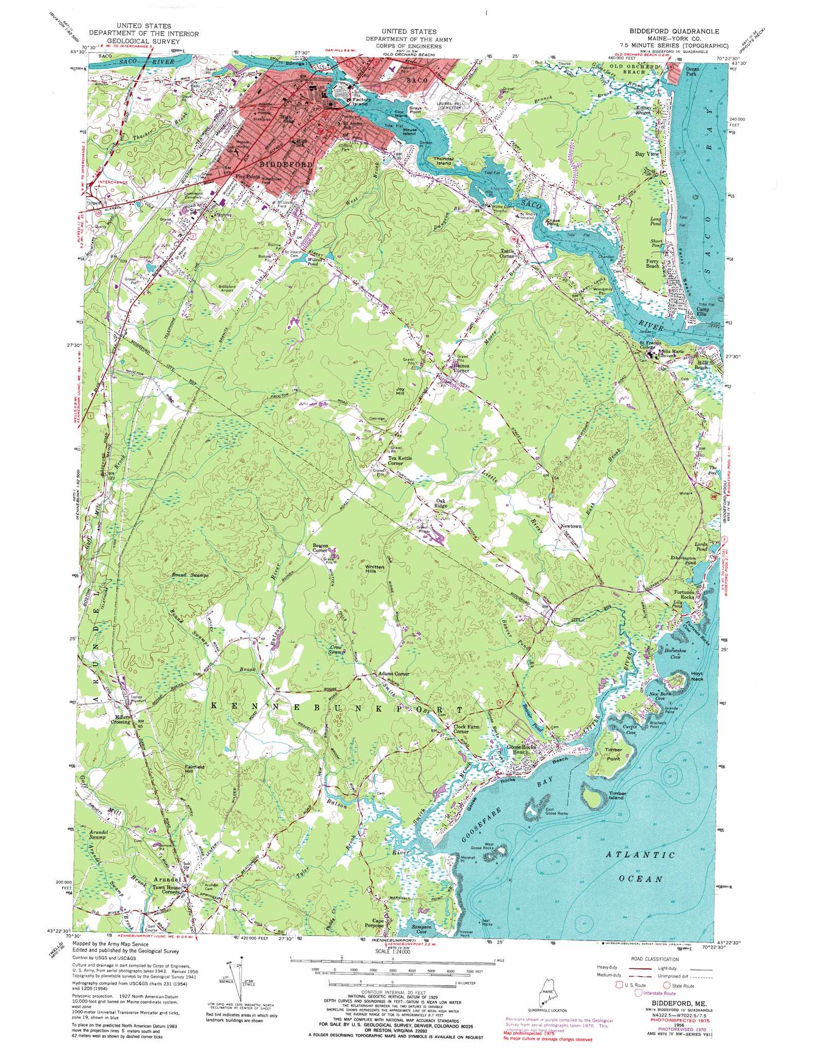
Biddeford Topo Map Maine
To zoom in, hover over the map of Biddeford
USGS Topo Quad 43070d4 - 1:24,000 scale
| Topo Map Name: | Biddeford |
| USGS Topo Quad ID: | 43070d4 |
| Print Size: | ca. 21 1/4" wide x 27" high |
| Southeast Coordinates: | 43.375° N latitude / 70.375° W longitude |
| Map Center Coordinates: | 43.4375° N latitude / 70.4375° W longitude |
| U.S. State: | ME |
| Filename: | o43070d4.jpg |
| Download Map JPG Image: | Biddeford topo map 1:24,000 scale |
| Map Type: | Topographic |
| Topo Series: | 7.5´ |
| Map Scale: | 1:24,000 |
| Source of Map Images: | United States Geological Survey (USGS) |
| Alternate Map Versions: |
Biddeford ME 1956, updated 1958 Download PDF Buy paper map Biddeford ME 1956, updated 1967 Download PDF Buy paper map Biddeford ME 1956, updated 1971 Download PDF Buy paper map Biddeford ME 1956, updated 1980 Download PDF Buy paper map Biddeford ME 1975, updated 1979 Download PDF Buy paper map Biddeford ME 2011 Download PDF Buy paper map Biddeford ME 2014 Download PDF Buy paper map |
1:24,000 Topo Quads surrounding Biddeford
Limington |
Standish |
Gorham |
Portland West |
Portland East |
Waterboro |
Bar Mills |
Old Orchard Beach |
Prouts Neck |
Cape Elizabeth |
Alfred |
Kennebunk |
Biddeford |
Biddeford Pool |
|
North Berwick |
Wells |
Kennebunkport |
||
York Harbor |
York Beach |
> Back to 43070a1 at 1:100,000 scale
> Back to 43070a1 at 1:250,000 scale
> Back to U.S. Topo Maps home
Biddeford topo map: Gazetteer
Biddeford: Airports
Back Acres Airport elevation 16m 52′Biddeford Municipal Airport elevation 47m 154′
Goosefair Airport elevation 12m 39′
Biddeford: Bars
Seal Rocks elevation 0m 0′Biddeford: Bays
Curtis Cove elevation 0m 0′Fortunes Rocks Cove elevation 1m 3′
Goosefare Bay elevation 0m 0′
Horseshoe Cove elevation 0m 0′
New Barn Cove elevation 0m 0′
Sampson Cove elevation 0m 0′
Biddeford: Beaches
Camp Ellis Reach elevation 0m 0′Ferry Beach elevation 0m 0′
Freddy Beach elevation 7m 22′
Goose Rocks Beach elevation 0m 0′
Biddeford: Capes
Bracketts Point elevation 0m 0′Chandler Point elevation 2m 6′
Chase Point elevation 5m 16′
Edgecomb Point elevation 6m 19′
Gordon Point elevation 14m 45′
Granite Point elevation 6m 19′
Hills Point elevation 2m 6′
Hoyt Neck elevation 7m 22′
Jordan Point elevation 1m 3′
Junkins Point elevation 15m 49′
Marshall Point elevation 0m 0′
Nessler Point elevation 0m 0′
Thunder Island elevation 16m 52′
Timber Point elevation 7m 22′
Windmill Point elevation 0m 0′
Biddeford: Crossings
Interchange 4 elevation 28m 91′Biddeford: Dams
Batson River Dam elevation 0m 0′Bradley-Springs Island Dam elevation 13m 42′
Cataract Dam elevation 8m 26′
West Channel Dam elevation 13m 42′
Biddeford: Islands
Cow Island elevation 0m 0′Cow Island Ledge elevation 0m 0′
East Goose Rocks elevation 0m 0′
Factory Island elevation 18m 59′
Mouse Island elevation 0m 0′
Springs Island elevation 18m 59′
Timber Island elevation 0m 0′
West Goose Rocks elevation 0m 0′
Biddeford: Lakes
Beaver Pond elevation 3m 9′Etherington Pond elevation 3m 9′
Lily Pond elevation 1m 3′
Long Pond elevation 3m 9′
Lords Pond elevation 3m 9′
Short Pond elevation 3m 9′
Wilcox Pond elevation 39m 127′
Biddeford: Parks
Clifford Park elevation 48m 157′Pepperell Park elevation 19m 62′
Saint Louis Field elevation 40m 131′
Waterhouse Field elevation 42m 137′
Biddeford: Populated Places
Adams Corner elevation 13m 42′Airport Village elevation 51m 167′
Arundel elevation 13m 42′
Bay View elevation 1m 3′
Beacon Corner elevation 20m 65′
Biddeford elevation 21m 68′
Camp Ellis elevation 0m 0′
Clock Farm Corner elevation 6m 19′
Ferry Beach elevation 6m 19′
Five Points elevation 45m 147′
Fortunes Rocks elevation 0m 0′
Goose Rocks Beach elevation 3m 9′
Guinea Corner elevation 18m 59′
Hills Beach elevation 6m 19′
Kinney Shores elevation 1m 3′
Millers Crossing elevation 18m 59′
Newtown elevation 12m 39′
Oak Ridge elevation 25m 82′
Tattle Corner elevation 12m 39′
Tea Kettle Corner elevation 24m 78′
Town House Corners elevation 13m 42′
Biddeford: Post Offices
Biddeford Post Office elevation 24m 78′Biddeford: Reservoirs
Batson River Reservoir elevation 11m 36′Saco River Reservoir elevation 13m 42′
Saco River Reservoir elevation 15m 49′
Biddeford: Streams
Batson River elevation 0m 0′Beaver Pond Brook elevation 0m 0′
Branch Brook elevation 3m 9′
Bush Brook elevation 6m 19′
Dungeon Brook elevation 0m 0′
Goose Rocks Creek elevation 0m 0′
Goosefare Brook elevation 0m 0′
Little River elevation 0m 0′
Moors Brook elevation 1m 3′
Round Swamps Brook elevation 12m 39′
Smith Brook elevation 0m 0′
Smith Brook elevation -1m -4′
Thacher Brook elevation 13m 42′
Tyler Brook elevation 0m 0′
West Brook elevation 2m 6′
Biddeford: Summits
Fairfield Hill elevation 43m 141′Joy Hill elevation 49m 160′
Whitten Hills elevation 22m 72′
Biddeford: Swamps
Arundel Swamp elevation 12m 39′Crow Swamp elevation 16m 52′
Great Heath elevation 48m 157′
Round Swamps elevation 42m 137′
Biddeford digital topo map on disk
Buy this Biddeford topo map showing relief, roads, GPS coordinates and other geographical features, as a high-resolution digital map file on DVD:
Maine, New Hampshire, Rhode Island & Eastern Massachusetts
Buy digital topo maps: Maine, New Hampshire, Rhode Island & Eastern Massachusetts