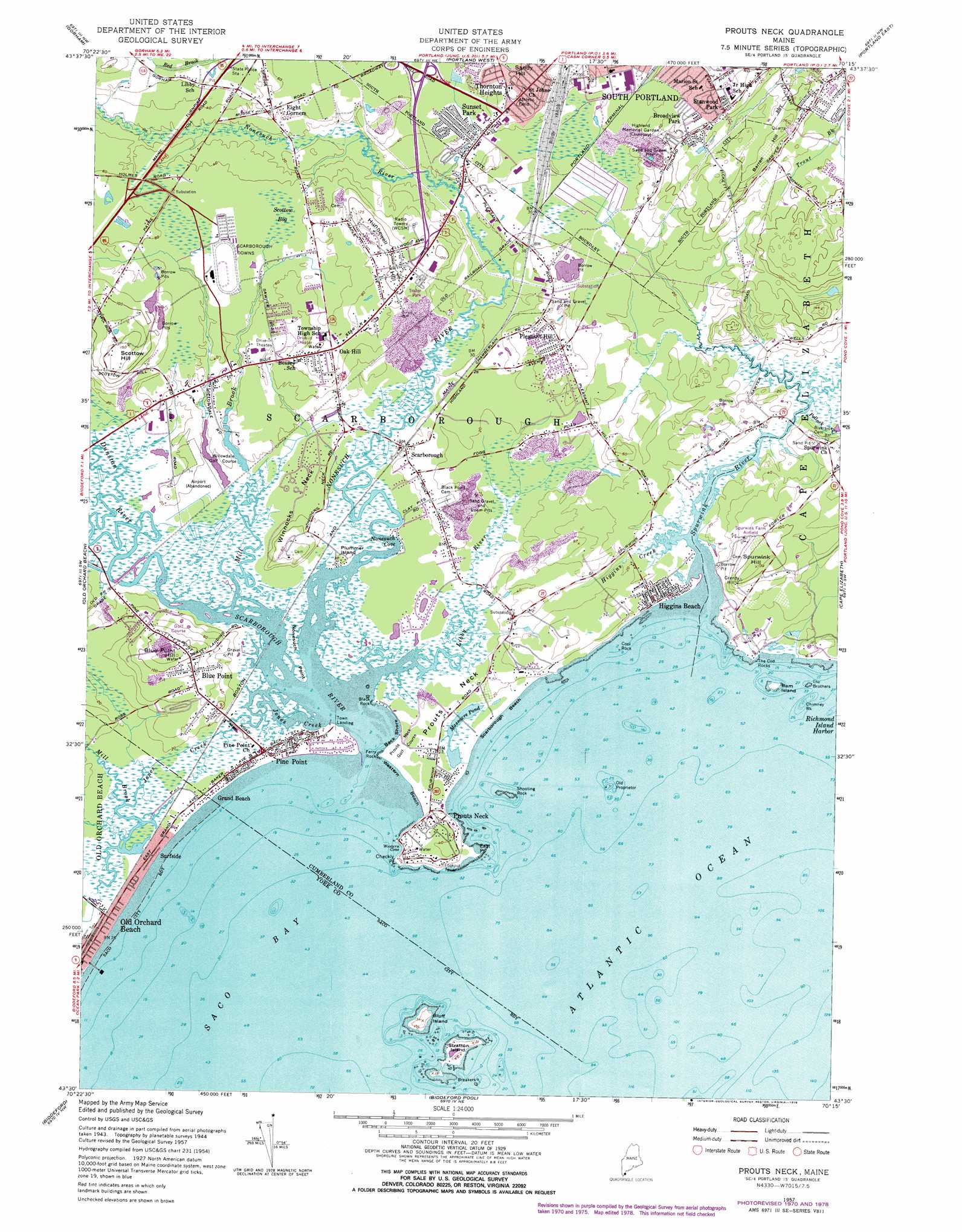
Prouts Neck Topo Map Maine
To zoom in, hover over the map of Prouts Neck
USGS Topo Quad 43070e3 - 1:24,000 scale
| Topo Map Name: | Prouts Neck |
| USGS Topo Quad ID: | 43070e3 |
| Print Size: | ca. 21 1/4" wide x 27" high |
| Southeast Coordinates: | 43.5° N latitude / 70.25° W longitude |
| Map Center Coordinates: | 43.5625° N latitude / 70.3125° W longitude |
| U.S. State: | ME |
| Filename: | o43070e3.jpg |
| Download Map JPG Image: | Prouts Neck topo map 1:24,000 scale |
| Map Type: | Topographic |
| Topo Series: | 7.5´ |
| Map Scale: | 1:24,000 |
| Source of Map Images: | United States Geological Survey (USGS) |
| Alternate Map Versions: |
Prouts Neck ME 1944 Download PDF Buy paper map Prouts Neck ME 1957, updated 1965 Download PDF Buy paper map Prouts Neck ME 1957, updated 1971 Download PDF Buy paper map Prouts Neck ME 1957, updated 1978 Download PDF Buy paper map Prouts Neck ME 1957, updated 1978 Download PDF Buy paper map Prouts Neck ME 1959, updated 1959 Download PDF Buy paper map Prouts Neck ME 1975, updated 1979 Download PDF Buy paper map Prouts Neck ME 2011 Download PDF Buy paper map Prouts Neck ME 2014 Download PDF Buy paper map |
1:24,000 Topo Quads surrounding Prouts Neck
Sebago Lake |
North Windham |
Cumberland Center |
Yarmouth |
Freeport |
Standish |
Gorham |
Portland West |
Portland East |
South Harpswell |
Bar Mills |
Old Orchard Beach |
Prouts Neck |
Cape Elizabeth |
|
Kennebunk |
Biddeford |
Biddeford Pool |
||
Wells |
Kennebunkport |
> Back to 43070e1 at 1:100,000 scale
> Back to 43070a1 at 1:250,000 scale
> Back to U.S. Topo Maps home
Prouts Neck topo map: Gazetteer
Prouts Neck: Airports
Oak Knoll Airport (historical) elevation 37m 121′Port O'Maine Airport elevation 9m 29′
Royal Anchor Heliport elevation 0m 0′
Scottow Bog Flightpark elevation 11m 36′
Spurwink Farm Airfield elevation 27m 88′
Prouts Neck: Bars
Bar Ledge elevation 0m 0′Black Rock elevation 0m 0′
Chimney Rock elevation 0m 0′
Cool Rock elevation 0m 0′
Little River Rock elevation 0m 0′
Old Proprietor elevation 0m 0′
Shooting Rock elevation 0m 0′
The Brothers elevation 0m 0′
Prouts Neck: Bays
Nonesuch Cove elevation 0m 0′Western Cove elevation 0m 0′
Prouts Neck: Beaches
Back Shore elevation 0m 0′Old Orchard Beach elevation 0m 0′
Pine Point Beach elevation 0m 0′
Scarborough Beach elevation 0m 0′
Surfside Beach elevation 0m 0′
Western Beach elevation 0m 0′
Prouts Neck: Capes
Checkly Point elevation 2m 6′East Point elevation 0m 0′
Ferry Rock elevation 0m 0′
Nonesuch Point elevation 0m 0′
Prouts Neck elevation 2m 6′
The Cod Rocks elevation 0m 0′
Winnocks Neck elevation 2m 6′
Prouts Neck: Crossings
Interchange 6 elevation 16m 52′Prouts Neck: Dams
Mill Brook Dam elevation 4m 13′Prouts Neck: Islands
Bluff Island elevation 9m 29′Plummer Island elevation 6m 19′
Ram Island elevation 1m 3′
Stratton Island elevation 5m 16′
Prouts Neck: Lakes
Massacre Pond elevation 2m 6′Prouts Neck: Parks
Ferry Beach State Park elevation 0m 0′Phineas W Sprague Memorial Sanctuary elevation 2m 6′
Prouts Neck Bird Sanctuary elevation 12m 39′
Scarborough Beach State Park elevation 1m 3′
Prouts Neck: Populated Places
Blue Point elevation 27m 88′Broadview Park elevation 25m 82′
Danish Village (historical) elevation 10m 32′
Eight Corners elevation 12m 39′
Grand Beach elevation 1m 3′
Higgins Beach elevation 4m 13′
Oak Hill elevation 26m 85′
Pine Point elevation 1m 3′
Pine Point Beach elevation 1m 3′
Pleasant Hill elevation 26m 85′
Prouts Neck elevation 11m 36′
Rigby (historical) elevation 11m 36′
Scarborough elevation 6m 19′
Stanwood Park elevation 30m 98′
Sunset Park elevation 13m 42′
Surfside elevation 1m 3′
Thornton Heights elevation 31m 101′
Town Landing elevation 0m 0′
Prouts Neck: Reservoirs
Mill Brook elevation 4m 13′Prouts Neck: Streams
Cascade Brook elevation 0m 0′Dunstan River elevation 0m 0′
Dyer Brook elevation 4m 13′
Higgins Creek elevation 0m 0′
Jones Creek elevation 0m 0′
Libby River elevation -3m -10′
Mill Brook elevation 2m 6′
Mill Brook elevation 0m 0′
Nonesuch River elevation 0m 0′
Phillips Brook elevation 0m 0′
Pollack Creek elevation 0m 0′
Scarborough River elevation 0m 0′
Spurwink River elevation 0m 0′
Prouts Neck: Summits
Barren Hill elevation 43m 141′Blue Point Hill elevation 39m 127′
Hunnewell Hill elevation 37m 121′
Sandy Hill elevation 33m 108′
Scottow Hill elevation 44m 144′
Spurwink Hill elevation 37m 121′
Prouts Neck: Swamps
Rigby Bog (historical) elevation 9m 29′Scarboro Marshes elevation 0m 0′
Scottow Bog elevation 16m 52′
Prouts Neck digital topo map on disk
Buy this Prouts Neck topo map showing relief, roads, GPS coordinates and other geographical features, as a high-resolution digital map file on DVD:
Maine, New Hampshire, Rhode Island & Eastern Massachusetts
Buy digital topo maps: Maine, New Hampshire, Rhode Island & Eastern Massachusetts