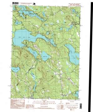
Great East Lake Topo Map Maine
To zoom in, hover over the map of Great East Lake
USGS Topo Quad 43070e8 - 1:24,000 scale
| Topo Map Name: | Great East Lake |
| USGS Topo Quad ID: | 43070e8 |
| Print Size: | ca. 21 1/4" wide x 27" high |
| Southeast Coordinates: | 43.5° N latitude / 70.875° W longitude |
| Map Center Coordinates: | 43.5625° N latitude / 70.9375° W longitude |
| U.S. States: | ME, NH |
| Filename: | o43070e8.jpg |
| Download Map JPG Image: | Great East Lake topo map 1:24,000 scale |
| Map Type: | Topographic |
| Topo Series: | 7.5´ |
| Map Scale: | 1:24,000 |
| Source of Map Images: | United States Geological Survey (USGS) |
| Alternate Map Versions: |
Great East Lake ME 1983, updated 1984 Download PDF Buy paper map Great East Lake ME 1983, updated 1984 Download PDF Buy paper map Great East Lake ME 1995, updated 1999 Download PDF Buy paper map Great East Lake ME 2011 Download PDF Buy paper map Great East Lake ME 2014 Download PDF Buy paper map |
1:24,000 Topo Quads surrounding Great East Lake
> Back to 43070e1 at 1:100,000 scale
> Back to 43070a1 at 1:250,000 scale
> Back to U.S. Topo Maps home
Great East Lake topo map: Gazetteer
Great East Lake: Airports
Buzzys Field elevation 194m 636′Mellion Airport elevation 214m 702′
Square Pond Seaplane Base elevation 159m 521′
Great East Lake: Beaches
Great East Lake Beach elevation 174m 570′Lake Ivanhoe Beach elevation 183m 600′
Great East Lake: Dams
Balch Pond Outlet Dam elevation 184m 603′Great East Lake Dam elevation 175m 574′
Horn Pond Dam elevation 168m 551′
Salmon Falls River 10 Dam elevation 153m 501′
Shapleigh Pond Dam elevation 152m 498′
Great East Lake: Islands
Shepherd Island elevation 177m 580′Great East Lake: Lakes
Balch Pond elevation 170m 557′Balch Pond elevation 170m 557′
Folsom Pond elevation 174m 570′
Hansen Pond elevation 154m 505′
Hidden Lake elevation 171m 561′
Horn Pond elevation 168m 551′
Lake Ivanhoe elevation 183m 600′
Loon Pond elevation 146m 479′
Mirror Lake elevation 152m 498′
Moose Pond elevation 174m 570′
Mud Pond elevation 150m 492′
Round Pond elevation 151m 495′
Smarts Pond elevation 154m 505′
Stump Pond elevation 170m 557′
Stump Pond elevation 170m 557′
Swan Pond elevation 164m 538′
Wilson Lake elevation 175m 574′
Great East Lake: Populated Places
Acton elevation 218m 715′Milton Mills elevation 138m 452′
North Shapleigh elevation 165m 541′
Shady Nook elevation 214m 702′
South Acton elevation 180m 590′
Great East Lake: Reservoirs
Balch Pond elevation 184m 603′Great East Lake elevation 175m 574′
Horn Pond elevation 168m 551′
Salmon Falls River Reservoir elevation 153m 501′
Shapleigh Pond elevation 152m 498′
Great East Lake: Ridges
Acton Ridge elevation 260m 853′Hubbard Ridge elevation 197m 646′
Great East Lake: Streams
Copp Brook elevation 174m 570′Copp Brook elevation 175m 574′
Farnham Brook elevation 158m 518′
Great East Lake: Summits
Berry Hill elevation 248m 813′Bond Mountain elevation 251m 823′
Davis Hill elevation 324m 1062′
Gerrish Mountain elevation 280m 918′
Gile Mountain elevation 259m 849′
Horn Hill elevation 239m 784′
Hussey Hill elevation 315m 1033′
Oak Hill elevation 330m 1082′
Perkins Hill elevation 236m 774′
Great East Lake digital topo map on disk
Buy this Great East Lake topo map showing relief, roads, GPS coordinates and other geographical features, as a high-resolution digital map file on DVD:
Maine, New Hampshire, Rhode Island & Eastern Massachusetts
Buy digital topo maps: Maine, New Hampshire, Rhode Island & Eastern Massachusetts


