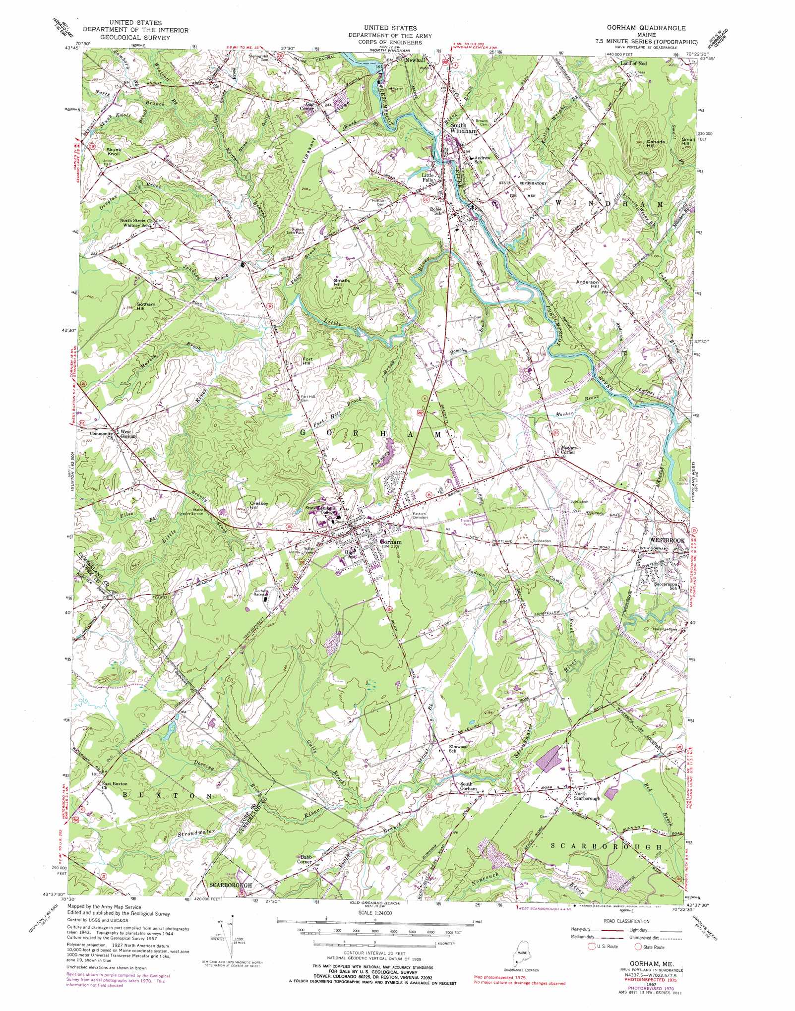
Gorham Topo Map Maine
To zoom in, hover over the map of Gorham
USGS Topo Quad 43070f4 - 1:24,000 scale
| Topo Map Name: | Gorham |
| USGS Topo Quad ID: | 43070f4 |
| Print Size: | ca. 21 1/4" wide x 27" high |
| Southeast Coordinates: | 43.625° N latitude / 70.375° W longitude |
| Map Center Coordinates: | 43.6875° N latitude / 70.4375° W longitude |
| U.S. State: | ME |
| Filename: | o43070f4.jpg |
| Download Map JPG Image: | Gorham topo map 1:24,000 scale |
| Map Type: | Topographic |
| Topo Series: | 7.5´ |
| Map Scale: | 1:24,000 |
| Source of Map Images: | United States Geological Survey (USGS) |
| Alternate Map Versions: |
Gorham ME 1950 Download PDF Buy paper map Gorham ME 1950 Download PDF Buy paper map Gorham ME 1957, updated 1958 Download PDF Buy paper map Gorham ME 1957, updated 1971 Download PDF Buy paper map Gorham ME 1957, updated 1977 Download PDF Buy paper map Gorham ME 1975, updated 1979 Download PDF Buy paper map Gorham ME 2011 Download PDF Buy paper map Gorham ME 2014 Download PDF Buy paper map |
1:24,000 Topo Quads surrounding Gorham
North Sebago |
Naples |
Raymond |
Gray |
North Pownal |
Steep Falls |
Sebago Lake |
North Windham |
Cumberland Center |
Yarmouth |
Limington |
Standish |
Gorham |
Portland West |
Portland East |
Waterboro |
Bar Mills |
Old Orchard Beach |
Prouts Neck |
Cape Elizabeth |
Alfred |
Kennebunk |
Biddeford |
Biddeford Pool |
> Back to 43070e1 at 1:100,000 scale
> Back to 43070a1 at 1:250,000 scale
> Back to U.S. Topo Maps home
Gorham topo map: Gazetteer
Gorham: Airports
Webster Field elevation 63m 206′Gorham: Dams
Gambo Falls Dam elevation 37m 121′Little Falls Dam elevation 30m 98′
Mallison Falls Dam elevation 24m 78′
Gorham: Falls
Mallison Falls elevation 24m 78′Gorham: Parks
Gorham Campus Historic District elevation 93m 305′South Street Historic District elevation 66m 216′
Gorham: Populated Places
Babb Corner elevation 37m 121′Gag Corner elevation 71m 232′
Gorham elevation 73m 239′
Little Falls elevation 40m 131′
Mosher Corner elevation 40m 131′
North Scarborough elevation 32m 104′
South Gorham elevation 37m 121′
South Windham elevation 37m 121′
West Gorham elevation 74m 242′
Gorham: Ridges
Pleasant Ridge elevation 74m 242′Gorham: Streams
Anderson Brook elevation 18m 59′Black Brook elevation 42m 137′
Brandy Brook elevation 37m 121′
Cold Spring Brook elevation 30m 98′
Colley Wright Brook elevation 25m 82′
Deering Brook elevation 28m 91′
Douglas Brook elevation 30m 98′
Farm Brook elevation 30m 98′
Files Brook elevation 40m 131′
Fort Hill Brook elevation 34m 111′
Gully Brook elevation 27m 88′
Hamblen Brook elevation 39m 127′
Indian Camp Brook elevation 16m 52′
Inkhorn Brook elevation 18m 59′
Johnson Brook elevation 30m 98′
Lincoln Weeks Brook elevation 49m 160′
Little River elevation 25m 82′
Martin Brook elevation 37m 121′
Milliken Brook elevation 29m 95′
Mosher Brook elevation 21m 68′
North Branch Little River elevation 34m 111′
Samborn Brook elevation 35m 114′
Skunk Knoll Brook elevation 35m 114′
South Branch Stroudwater River elevation 21m 68′
Strout Brook elevation 29m 95′
Tannery Brook elevation 18m 59′
Ward Brook elevation 44m 144′
Westcott Brook elevation 35m 114′
Gorham: Summits
Anderson Hill elevation 61m 200′Canada Hill elevation 107m 351′
Cressey Hill elevation 97m 318′
Fort Hill elevation 87m 285′
Gotham Hill elevation 84m 275′
Skunk Knoll elevation 82m 269′
Small Hill elevation 88m 288′
Smalls Hill elevation 74m 242′
Gorham: Valleys
Shad Gully elevation 36m 118′Gorham digital topo map on disk
Buy this Gorham topo map showing relief, roads, GPS coordinates and other geographical features, as a high-resolution digital map file on DVD:
Maine, New Hampshire, Rhode Island & Eastern Massachusetts
Buy digital topo maps: Maine, New Hampshire, Rhode Island & Eastern Massachusetts