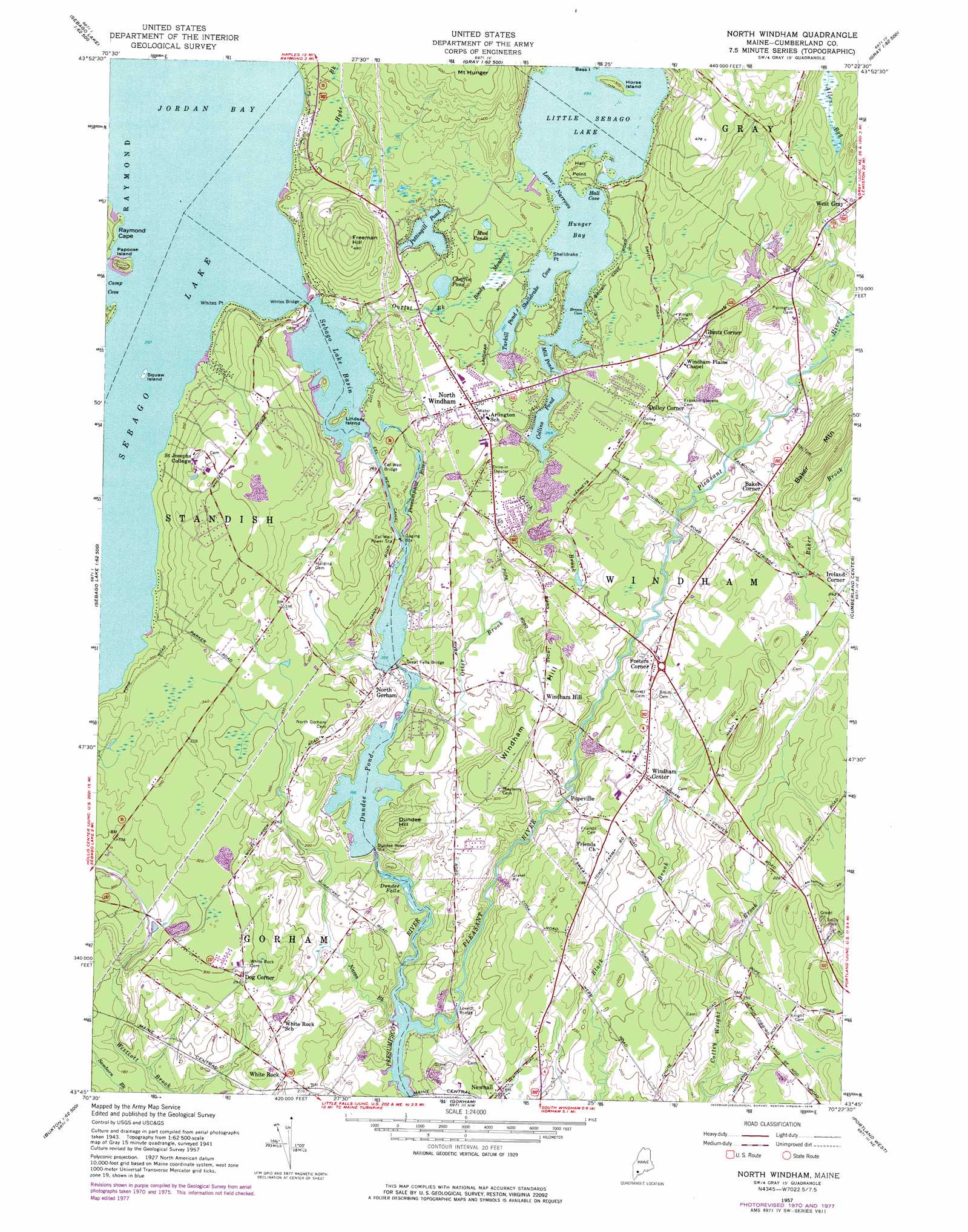
North Windham Topo Map Maine
To zoom in, hover over the map of North Windham
USGS Topo Quad 43070g4 - 1:24,000 scale
| Topo Map Name: | North Windham |
| USGS Topo Quad ID: | 43070g4 |
| Print Size: | ca. 21 1/4" wide x 27" high |
| Southeast Coordinates: | 43.75° N latitude / 70.375° W longitude |
| Map Center Coordinates: | 43.8125° N latitude / 70.4375° W longitude |
| U.S. State: | ME |
| Filename: | o43070g4.jpg |
| Download Map JPG Image: | North Windham topo map 1:24,000 scale |
| Map Type: | Topographic |
| Topo Series: | 7.5´ |
| Map Scale: | 1:24,000 |
| Source of Map Images: | United States Geological Survey (USGS) |
| Alternate Map Versions: |
North Windham ME 1957, updated 1959 Download PDF Buy paper map North Windham ME 1957, updated 1971 Download PDF Buy paper map North Windham ME 1957, updated 1978 Download PDF Buy paper map North Windham ME 1957, updated 1978 Download PDF Buy paper map North Windham ME 2011 Download PDF Buy paper map North Windham ME 2014 Download PDF Buy paper map |
1:24,000 Topo Quads surrounding North Windham
Bridgton |
Casco |
Mechanic Falls |
Minot |
Lewiston |
North Sebago |
Naples |
Raymond |
Gray |
North Pownal |
Steep Falls |
Sebago Lake |
North Windham |
Cumberland Center |
Yarmouth |
Limington |
Standish |
Gorham |
Portland West |
Portland East |
Waterboro |
Bar Mills |
Old Orchard Beach |
Prouts Neck |
Cape Elizabeth |
> Back to 43070e1 at 1:100,000 scale
> Back to 43070a1 at 1:250,000 scale
> Back to U.S. Topo Maps home
North Windham topo map: Gazetteer
North Windham: Airports
Sand Bar Seaplane Base elevation 87m 285′North Windham: Bays
Brown Cove elevation 87m 285′Camp Cove elevation 81m 265′
Clubhouse Cove elevation 87m 285′
Hall Cove elevation 87m 285′
Hall Cove elevation 87m 285′
Hunger Bay elevation 87m 285′
Shelldrake Cove elevation 87m 285′
North Windham: Bridges
Babbs Bridge elevation 37m 121′Eel Weir Bridge elevation 76m 249′
Great Falls Bridge elevation 57m 187′
Loveitt Bridge elevation 37m 121′
Whites Bridge elevation 81m 265′
North Windham: Canals
Eel Weir Canal elevation 77m 252′North Windham: Capes
Hall Point elevation 91m 298′Raymond Cape elevation 82m 269′
Shelldrake Point elevation 87m 285′
Shelldrake Point elevation 90m 295′
Whites Point elevation 82m 269′
North Windham: Channels
Lower Narrows elevation 87m 285′North Windham: Dams
Dundee Pond Dam elevation 56m 183′Eel Weir Dam elevation 74m 242′
Little Sebago Lake Dam elevation 85m 278′
Mill Pond Dam elevation 93m 305′
North Gorham Dam elevation 68m 223′
Sebago Lake Dam elevation 81m 265′
North Windham: Falls
Dundee Falls elevation 38m 124′North Windham: Islands
Gillman Island elevation 68m 223′Horse Island elevation 90m 295′
Lindsay Island elevation 92m 301′
Papoose Island elevation 92m 301′
Squaw Island elevation 82m 269′
North Windham: Lakes
Chaffin Pond elevation 89m 291′Collins Pond elevation 82m 269′
Mud Ponds elevation 91m 298′
Pettingill Pond elevation 89m 291′
Tarkill Pond elevation 88m 288′
North Windham: Populated Places
Baker Corner elevation 72m 236′Dog Corner elevation 86m 282′
Dolley Corner elevation 92m 301′
Fosters Corner elevation 74m 242′
Gates Hill (historical) elevation 94m 308′
Glantz Corner elevation 93m 305′
Great Falls (historical) elevation 71m 232′
Ireland Corner elevation 75m 246′
Lowells Corner (historical) elevation 96m 314′
Newhall elevation 64m 209′
North Gorham elevation 96m 314′
North Windham elevation 93m 305′
Popeville elevation 60m 196′
West Gray elevation 94m 308′
White Rock elevation 66m 216′
Windham Center elevation 82m 269′
Windham Hill elevation 96m 314′
North Windham: Reservoirs
Dundee Pond elevation 56m 183′Eel Weir Canal elevation 68m 223′
Little Sebago Lake elevation 85m 278′
Mill Pond elevation 93m 305′
Sebago Lake Basin elevation 81m 265′
North Windham: Streams
Baker Brook elevation 51m 167′Ditch Brook elevation 52m 170′
Dutton Hills Brook elevation 51m 167′
Elmer Brook elevation 59m 193′
Glantz Brook elevation 84m 275′
Haskell Brook elevation 54m 177′
Legrand Brook elevation 58m 190′
Nason Brook elevation 38m 124′
Ollie Brook elevation 84m 275′
Otter Brook elevation 57m 187′
Outlet Brook elevation 81m 265′
Pleasant River elevation 37m 121′
Stanley Hall Brook elevation 54m 177′
North Windham: Summits
Allie Hawks Hill elevation 67m 219′Baker Mountain elevation 149m 488′
Boody Hill elevation 145m 475′
Crendell Hill elevation 75m 246′
Dundee Hill elevation 94m 308′
Freeman Hill elevation 148m 485′
Kimball Hill elevation 88m 288′
Knight Hill elevation 115m 377′
Nash Hill elevation 117m 383′
Reed Hill elevation 86m 282′
Rollins Hill elevation 92m 301′
Timmons Hill elevation 74m 242′
Whites Hill elevation 113m 370′
Windham Hill elevation 94m 308′
Woodbury Hill elevation 110m 360′
North Windham: Swamps
Allen Bog elevation 94m 308′Boody Meadow elevation 89m 291′
North Windham digital topo map on disk
Buy this North Windham topo map showing relief, roads, GPS coordinates and other geographical features, as a high-resolution digital map file on DVD:
Maine, New Hampshire, Rhode Island & Eastern Massachusetts
Buy digital topo maps: Maine, New Hampshire, Rhode Island & Eastern Massachusetts