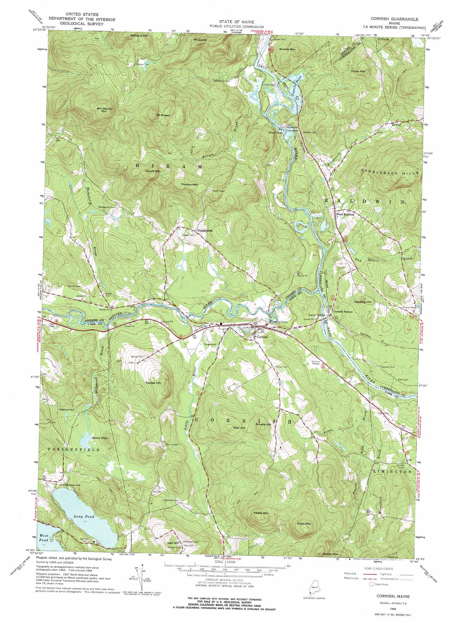
Cornish Topo Map Maine
To zoom in, hover over the map of Cornish
USGS Topo Quad 43070g7 - 1:24,000 scale
| Topo Map Name: | Cornish |
| USGS Topo Quad ID: | 43070g7 |
| Print Size: | ca. 21 1/4" wide x 27" high |
| Southeast Coordinates: | 43.75° N latitude / 70.75° W longitude |
| Map Center Coordinates: | 43.8125° N latitude / 70.8125° W longitude |
| U.S. State: | ME |
| Filename: | o43070g7.jpg |
| Download Map JPG Image: | Cornish topo map 1:24,000 scale |
| Map Type: | Topographic |
| Topo Series: | 7.5´ |
| Map Scale: | 1:24,000 |
| Source of Map Images: | United States Geological Survey (USGS) |
| Alternate Map Versions: |
Cornish ME 1964, updated 1966 Download PDF Buy paper map Cornish ME 1964, updated 1977 Download PDF Buy paper map Cornish ME 1964, updated 1977 Download PDF Buy paper map Cornish ME 1975, updated 1979 Download PDF Buy paper map Cornish ME 2011 Download PDF Buy paper map Cornish ME 2014 Download PDF Buy paper map |
1:24,000 Topo Quads surrounding Cornish
North Conway East |
Fryeburg |
Pleasant Mountain |
Bridgton |
Casco |
Conway |
Brownfield |
Hiram |
North Sebago |
Naples |
Freedom |
Kezar Falls |
Cornish |
Steep Falls |
Sebago Lake |
Ossipee |
West Newfield |
Limerick |
Limington |
Standish |
Sanbornville |
Great East Lake |
Mousam Lake |
Waterboro |
Bar Mills |
> Back to 43070e1 at 1:100,000 scale
> Back to 43070a1 at 1:250,000 scale
> Back to U.S. Topo Maps home
Cornish topo map: Gazetteer
Cornish: Dams
Hiram Falls Dam elevation 103m 337′Cornish: Falls
Great Falls elevation 96m 314′Cornish: Lakes
Ingalls Pond elevation 106m 347′Long Pond elevation 140m 459′
Spruce Pond elevation 129m 423′
West Pond elevation 169m 554′
Cornish: Populated Places
Cornish elevation 107m 351′Durgintown elevation 159m 521′
West Baldwin elevation 116m 380′
Cornish: Reservoirs
Saco River Reservoir elevation 103m 337′Cornish: Streams
Barnes Brook elevation 105m 344′Breakneck Brook elevation 80m 262′
Dug Hill Brook elevation 82m 269′
Little River elevation 81m 265′
Merrifield Brook elevation 110m 360′
Ossipee River elevation 79m 259′
Pease Brook elevation 81m 265′
Pugsley Brook elevation 113m 370′
Wadsworth Brook elevation 89m 291′
Wedgwood Brook elevation 93m 305′
Cornish: Summits
Bill Merrill Mountain elevation 491m 1610′Clark Mountain elevation 404m 1325′
Day Hill elevation 270m 885′
Flints Mountain elevation 280m 918′
Gould Mountain elevation 389m 1276′
Harding Hill elevation 190m 623′
Hosac Mountain elevation 393m 1289′
Mount Cutler elevation 376m 1233′
Mount Misery elevation 461m 1512′
Peaked Mountain elevation 330m 1082′
Pease Mountain elevation 354m 1161′
Pike Hill elevation 247m 810′
Robbins Hill elevation 414m 1358′
Smalls Hill elevation 283m 928′
Smalls Mountain elevation 224m 734′
Towles Hill elevation 249m 816′
Cornish digital topo map on disk
Buy this Cornish topo map showing relief, roads, GPS coordinates and other geographical features, as a high-resolution digital map file on DVD:
Maine, New Hampshire, Rhode Island & Eastern Massachusetts
Buy digital topo maps: Maine, New Hampshire, Rhode Island & Eastern Massachusetts