Hiram Topo Map Maine
To zoom in, hover over the map of Hiram
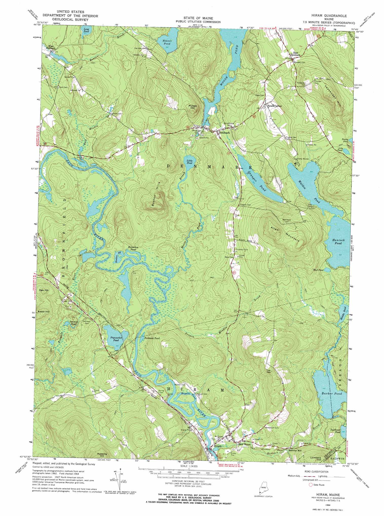
USGS Topo Quad 43070h7 - 1:24,000 scale
| Topo Map Name: | Hiram |
| USGS Topo Quad ID: | 43070h7 |
| Print Size: | ca. 21 1/4" wide x 27" high |
| Southeast Coordinates: | 43.875° N latitude / 70.75° W longitude |
| Map Center Coordinates: | 43.9375° N latitude / 70.8125° W longitude |
| U.S. State: | ME |
| Filename: | o43070h7.jpg |
| Download Map JPG Image: | Hiram topo map 1:24,000 scale |
| Map Type: | Topographic |
| Topo Series: | 7.5´ |
| Map Scale: | 1:24,000 |
| Source of Map Images: | United States Geological Survey (USGS) |
| Alternate Map Versions: |
Hiram ME 1964, updated 1966 Download PDF Buy paper map Hiram ME 1964, updated 1966 Download PDF Buy paper map Hiram ME 2011 Download PDF Buy paper map Hiram ME 2014 Download PDF Buy paper map |
1:24,000 Topo Quads surrounding Hiram
Chatham |
Center Lovell |
North Waterford |
Ralph |
Norway |
North Conway East |
Fryeburg |
Pleasant Mountain |
Bridgton |
Casco |
Conway |
Brownfield |
Hiram |
North Sebago |
Naples |
Freedom |
Kezar Falls |
Cornish |
Steep Falls |
Sebago Lake |
Ossipee |
West Newfield |
Limerick |
Limington |
Standish |
> Back to 43070e1 at 1:100,000 scale
> Back to 43070a1 at 1:250,000 scale
> Back to U.S. Topo Maps home
Hiram topo map: Gazetteer
Hiram: Dams
Barker Pond Dam elevation 151m 495′Hancock Pond Dam elevation 154m 505′
Moose Pond Dam elevation 128m 419′
Hiram: Lakes
Beaver Pond elevation 121m 396′Boston Pond elevation 107m 351′
Bryant Pond elevation 105m 344′
Burbank Pond elevation 107m 351′
Granger Pond elevation 160m 524′
Horseshoe Pond elevation 107m 351′
Lily Pond elevation 160m 524′
Little Pond elevation 111m 364′
Long Pond elevation 122m 400′
Middle Pond elevation 150m 492′
Mud Pond elevation 153m 501′
Pequawket Pond elevation 110m 360′
Tenmile Pond elevation 114m 374′
Walden Pond elevation 153m 501′
Hiram: Populated Places
Denmark elevation 161m 528′East Denmark elevation 214m 702′
East Hiram elevation 121m 396′
Heads Corner elevation 216m 708′
Hiram elevation 110m 360′
Rankins Mill elevation 131m 429′
West Denmark elevation 116m 380′
Hiram: Reservoirs
Barker Pond elevation 151m 495′Hancock Pond elevation 154m 505′
Moose Pond elevation 128m 419′
Hiram: Streams
Buck Meadow Brook elevation 108m 354′Burnt Meadow Brook elevation 108m 354′
Dragon Meadow Brook elevation 106m 347′
Hancock Brook elevation 109m 357′
Moose Pond Brook elevation 106m 347′
Tenmile River elevation 105m 344′
Hiram: Summits
Allen Mountain elevation 340m 1115′Boston Hills elevation 264m 866′
Fessenden Hill elevation 313m 1026′
Kezar Hill elevation 210m 688′
Lombard Hill elevation 270m 885′
Oak Hill elevation 195m 639′
Pickett Hill elevation 240m 787′
Tear Cap elevation 304m 997′
Hiram digital topo map on disk
Buy this Hiram topo map showing relief, roads, GPS coordinates and other geographical features, as a high-resolution digital map file on DVD:
Maine, New Hampshire, Rhode Island & Eastern Massachusetts
Buy digital topo maps: Maine, New Hampshire, Rhode Island & Eastern Massachusetts