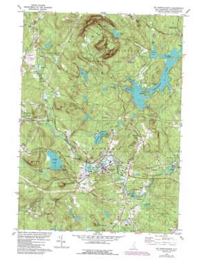
Mount Pawtuckaway Topo Map New Hampshire
To zoom in, hover over the map of Mount Pawtuckaway
USGS Topo Quad 43071a2 - 1:24,000 scale
| Topo Map Name: | Mount Pawtuckaway |
| USGS Topo Quad ID: | 43071a2 |
| Print Size: | ca. 21 1/4" wide x 27" high |
| Southeast Coordinates: | 43° N latitude / 71.125° W longitude |
| Map Center Coordinates: | 43.0625° N latitude / 71.1875° W longitude |
| U.S. State: | NH |
| Filename: | o43071a2.jpg |
| Download Map JPG Image: | Mount Pawtuckaway topo map 1:24,000 scale |
| Map Type: | Topographic |
| Topo Series: | 7.5´ |
| Map Scale: | 1:24,000 |
| Source of Map Images: | United States Geological Survey (USGS) |
| Alternate Map Versions: |
Mt. Pawtuckaway NH 1981, updated 1981 Download PDF Buy paper map Mt. Pawtuckaway NH 1981, updated 1988 Download PDF Buy paper map Mt. Pawtuckaway NH 1981, updated 1988 Download PDF Buy paper map Mount Pawtuckaway NH 2012 Download PDF Buy paper map Mount Pawtuckaway NH 2015 Download PDF Buy paper map |
1:24,000 Topo Quads surrounding Mount Pawtuckaway
> Back to 43071a1 at 1:100,000 scale
> Back to 43070a1 at 1:250,000 scale
> Back to U.S. Topo Maps home
Mount Pawtuckaway topo map: Gazetteer
Mount Pawtuckaway: Airports
Falcon Station Heliport elevation 45m 147′Mount Pawtuckaway: Bays
Fundy Cove elevation 77m 252′Mountain Cove elevation 77m 252′
Neals Cove elevation 78m 255′
Mount Pawtuckaway: Capes
Seamans Point elevation 80m 262′Mount Pawtuckaway: Dams
Deer Pond Dam elevation 133m 436′Dolloff Dam elevation 82m 269′
Drowns Dam elevation 77m 252′
Gove Dike elevation 78m 255′
Mountain Brook Dam elevation 98m 321′
Onway Lake Dam elevation 81m 265′
Mount Pawtuckaway: Islands
Big Island elevation 112m 367′Horse Island elevation 79m 259′
Log Cabin elevation 79m 259′
Mount Pawtuckaway: Lakes
Governors Lake elevation 84m 275′Mountain Pond elevation 80m 262′
Onway Lake elevation 80m 262′
Round Pond elevation 100m 328′
Mount Pawtuckaway: Parks
Pawtuckaway State Reservation elevation 162m 531′Mount Pawtuckaway: Populated Places
Bean Island elevation 67m 219′East Candia elevation 135m 442′
Onway Lake elevation 81m 265′
Raymond elevation 61m 200′
Mount Pawtuckaway: Reservoirs
Bunker Pond elevation 44m 144′Dead Pond elevation 47m 154′
Deer Pond elevation 133m 436′
Loon Pond elevation 54m 177′
Mountain Brook Pond elevation 98m 321′
Pawtuckaway Pond elevation 77m 252′
Pawtuckaway Pond elevation 78m 255′
Pawtuckaway Pond elevation 76m 249′
Mount Pawtuckaway: Streams
Back Creek elevation 80m 262′Dudley Brook elevation 60m 196′
Hartford Brook elevation 72m 236′
Mountain Brook elevation 79m 259′
Nicholls Brook elevation 82m 269′
North Branch River elevation 62m 203′
Pawtuckaway River elevation 39m 127′
Mount Pawtuckaway: Summits
Beede Hill elevation 83m 272′Dumplingtown Hill elevation 190m 623′
Flint Hill elevation 121m 396′
Little Rattlesnake Hill elevation 95m 311′
Long Hill elevation 98m 321′
Mount Pawtuckaway elevation 296m 971′
Norway Hill elevation 152m 498′
Pawtuckaway Mountains elevation 200m 656′
Rattlesnake Hill elevation 135m 442′
Robinson Hill elevation 129m 423′
Tavern Hill elevation 185m 606′
Watson Hill elevation 151m 495′
Mount Pawtuckaway: Swamps
Burnhams Marshes elevation 77m 252′Mount Pawtuckaway digital topo map on disk
Buy this Mount Pawtuckaway topo map showing relief, roads, GPS coordinates and other geographical features, as a high-resolution digital map file on DVD:
Maine, New Hampshire, Rhode Island & Eastern Massachusetts
Buy digital topo maps: Maine, New Hampshire, Rhode Island & Eastern Massachusetts


