Candia Topo Map New Hampshire
To zoom in, hover over the map of Candia
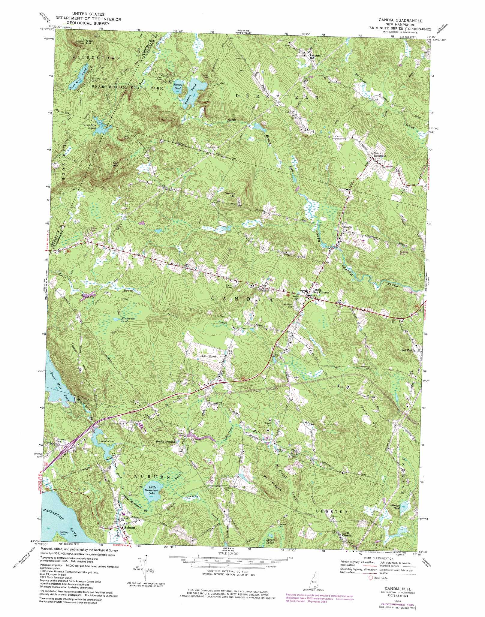
USGS Topo Quad 43071a3 - 1:24,000 scale
| Topo Map Name: | Candia |
| USGS Topo Quad ID: | 43071a3 |
| Print Size: | ca. 21 1/4" wide x 27" high |
| Southeast Coordinates: | 43° N latitude / 71.25° W longitude |
| Map Center Coordinates: | 43.0625° N latitude / 71.3125° W longitude |
| U.S. State: | NH |
| Filename: | o43071a3.jpg |
| Download Map JPG Image: | Candia topo map 1:24,000 scale |
| Map Type: | Topographic |
| Topo Series: | 7.5´ |
| Map Scale: | 1:24,000 |
| Source of Map Images: | United States Geological Survey (USGS) |
| Alternate Map Versions: |
Candia NH 1969, updated 1971 Download PDF Buy paper map Candia NH 1969, updated 1985 Download PDF Buy paper map Candia NH 2012 Download PDF Buy paper map Candia NH 2015 Download PDF Buy paper map |
1:24,000 Topo Quads surrounding Candia
Penacook |
Loudon |
Pittsfield |
Parker Mountain |
Baxter Lake |
Concord |
Suncook |
Gossville |
Northwood |
Barrington |
Goffstown |
Manchester North |
Candia |
Mount Pawtuckaway |
Epping |
Pinardville |
Manchester South |
Derry |
Sandown |
Kingston |
South Merrimack |
Nashua North |
Windham |
Haverhill |
> Back to 43071a1 at 1:100,000 scale
> Back to 43070a1 at 1:250,000 scale
> Back to U.S. Topo Maps home
Candia topo map: Gazetteer
Candia: Capes
Battery Point elevation 78m 255′Candia: Crossings
Interchange 2 elevation 90m 295′Interchange 3 elevation 120m 393′
Candia: Dams
Clark Pond East Dam elevation 82m 269′Clark Pond West Dam elevation 81m 265′
Hall Mountain Marsh Dam elevation 204m 669′
Tower Hill Pond Dam elevation 99m 324′
Candia: Lakes
Bear Hill Pond elevation 201m 659′Beaver Pond elevation 147m 482′
Kinnicum Pond elevation 157m 515′
Little Massabesic Lake elevation 78m 255′
Norton Pond elevation 105m 344′
Spruce Lakes elevation 98m 321′
Spruce Pond elevation 147m 482′
Candia: Parks
Bear Brook State Park elevation 190m 623′Moore Park elevation 150m 492′
Candia: Populated Places
Auburn elevation 78m 255′Candia elevation 110m 360′
Candia Four Corners elevation 150m 492′
Hooks Crossing elevation 96m 314′
Leavitts Hill elevation 132m 433′
North Chester elevation 139m 456′
South Deerfield elevation 169m 554′
Candia: Post Offices
Auburn Post Office elevation 79m 259′Candia Post Office elevation 137m 449′
Candia: Reservoirs
Clark Pond elevation 81m 265′Clark Pond elevation 82m 269′
Hall Mountain Marsh elevation 204m 669′
Tower Hill Pond elevation 99m 324′
Candia: Streams
Clark Pond Brook elevation 79m 259′Hook Brook elevation 78m 255′
Little Massabesic Brook elevation 78m 255′
Maple Falls Brook elevation 82m 269′
Mount Pisgah Brook elevation 97m 318′
Murray Mill Brook elevation 91m 298′
Preston Brook elevation 78m 255′
Sucker Brook elevation 78m 255′
Candia: Summits
Bear Hill elevation 254m 833′Hall Mountain elevation 286m 938′
Mount Pisgah elevation 160m 524′
Patten Hill elevation 189m 620′
Tower Hill elevation 209m 685′
Walnut Hill elevation 210m 688′
Candia: Swamps
Abe Emerson Marsh elevation 126m 413′Candia: Trails
Broken Boulder Smith Pond Trail elevation 153m 501′Campground Trail elevation 176m 577′
Candia digital topo map on disk
Buy this Candia topo map showing relief, roads, GPS coordinates and other geographical features, as a high-resolution digital map file on DVD:
Maine, New Hampshire, Rhode Island & Eastern Massachusetts
Buy digital topo maps: Maine, New Hampshire, Rhode Island & Eastern Massachusetts