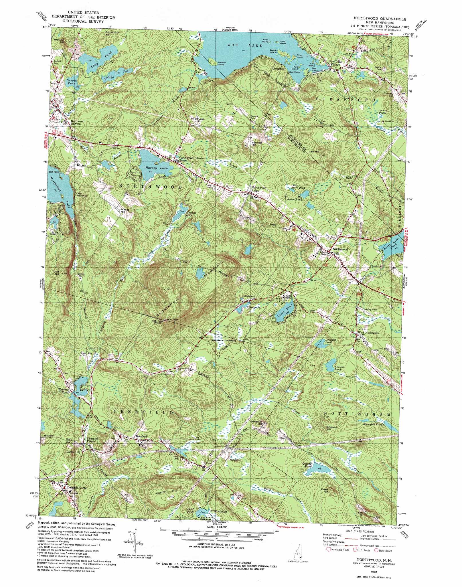
Northwood Topo Map New Hampshire
To zoom in, hover over the map of Northwood
USGS Topo Quad 43071b2 - 1:24,000 scale
| Topo Map Name: | Northwood |
| USGS Topo Quad ID: | 43071b2 |
| Print Size: | ca. 21 1/4" wide x 27" high |
| Southeast Coordinates: | 43.125° N latitude / 71.125° W longitude |
| Map Center Coordinates: | 43.1875° N latitude / 71.1875° W longitude |
| U.S. State: | NH |
| Filename: | o43071b2.jpg |
| Download Map JPG Image: | Northwood topo map 1:24,000 scale |
| Map Type: | Topographic |
| Topo Series: | 7.5´ |
| Map Scale: | 1:24,000 |
| Source of Map Images: | United States Geological Survey (USGS) |
| Alternate Map Versions: |
Northwood NH 1981, updated 1981 Download PDF Buy paper map Northwood NH 1981, updated 1988 Download PDF Buy paper map Northwood NH 1981, updated 1988 Download PDF Buy paper map Northwood NH 1995, updated 2000 Download PDF Buy paper map Northwood NH 2012 Download PDF Buy paper map Northwood NH 2015 Download PDF Buy paper map |
1:24,000 Topo Quads surrounding Northwood
Belmont |
Gilmanton Ironworks |
Alton |
Farmington |
Milton |
Loudon |
Pittsfield |
Parker Mountain |
Baxter Lake |
Rochester |
Suncook |
Gossville |
Northwood |
Barrington |
Dover West |
Manchester North |
Candia |
Mount Pawtuckaway |
Epping |
Newmarket |
Manchester South |
Derry |
Sandown |
Kingston |
> Back to 43071a1 at 1:100,000 scale
> Back to 43070a1 at 1:250,000 scale
> Back to U.S. Topo Maps home
Northwood topo map: Gazetteer
Northwood: Dams
Bow Lake Dam elevation 158m 518′Burtt Wildlife Pond Dam elevation 181m 593′
Dole Marsh Dam elevation 164m 538′
Foss Pond Dam elevation 203m 666′
Freeses Pond Dam elevation 130m 426′
Tudor Wildlife Pond Dam elevation 179m 587′
Voydatch Pond Dam elevation 196m 643′
Northwood: Flats
Bettys Meadows elevation 175m 574′Northwood: Forests
Woodman State Forest elevation 166m 544′Northwood: Islands
Beech Island elevation 158m 518′Bennett Island elevation 157m 515′
Loon Island elevation 158m 518′
Pine Island elevation 158m 518′
Rye Island elevation 158m 518′
York Island elevation 158m 518′
Northwood: Lakes
Big Acorn Pond elevation 200m 656′Demeritt Pond elevation 99m 324′
Harvey Lake elevation 187m 613′
Kenison Pond elevation 95m 311′
Little Acorn Pond elevation 212m 695′
Mulligan Ponds elevation 75m 246′
Quincy Pond elevation 93m 305′
Spruce Ponds elevation 158m 518′
Northwood: Parks
Lamontagne Wildlife Management Area elevation 99m 324′Northwood: Populated Places
Bow Lake Village elevation 158m 518′Deerfield elevation 159m 521′
Deerfield Center elevation 141m 462′
Deerfield Parade elevation 127m 416′
James City elevation 128m 419′
Melrose Beach elevation 134m 439′
Northwood elevation 170m 557′
Northwood Center elevation 193m 633′
Northwood Narrows elevation 175m 574′
Northwood Ridge elevation 244m 800′
West Nottingham elevation 107m 351′
Northwood: Post Offices
West Nottingham Post Office elevation 128m 419′Northwood: Reservoirs
Bow Lake elevation 158m 518′Burtt Wildlife Pond elevation 181m 593′
Dead Pond elevation 152m 498′
Dole Marsh elevation 164m 538′
Durgin Pond elevation 176m 577′
Foss Pond elevation 203m 666′
Freeses Pond elevation 130m 426′
Little Bow Pond elevation 179m 587′
Long Pond elevation 179m 587′
Lucas Pond elevation 132m 433′
Meadow Lake elevation 180m 590′
North River Pond elevation 137m 449′
Tudor Wildlife Pond elevation 179m 587′
Voydatch Pond elevation 196m 643′
Northwood: Streams
Jenness Brook elevation 177m 580′Kelsey Brook elevation 172m 564′
Sherburne Brook elevation 159m 521′
The Gulf elevation 161m 528′
Tucker Brook elevation 187m 613′
Northwood: Summits
Adams Hill elevation 194m 636′Bennett Hill elevation 252m 826′
Blakes Hill elevation 236m 774′
Browns Hill elevation 217m 711′
Caverly Hill elevation 197m 646′
Duke Hill elevation 116m 380′
Elm Hill elevation 138m 452′
Gulf Hill elevation 242m 793′
Oak Hill elevation 275m 902′
Richardson Hill elevation 223m 731′
Saddleback Mountain elevation 347m 1138′
Sherburne Hill elevation 248m 813′
Stevens Hill elevation 108m 354′
Wheeler Hill elevation 155m 508′
Northwood: Swamps
Woodman Marsh elevation 172m 564′Northwood digital topo map on disk
Buy this Northwood topo map showing relief, roads, GPS coordinates and other geographical features, as a high-resolution digital map file on DVD:
Maine, New Hampshire, Rhode Island & Eastern Massachusetts
Buy digital topo maps: Maine, New Hampshire, Rhode Island & Eastern Massachusetts