Concord Topo Map New Hampshire
To zoom in, hover over the map of Concord
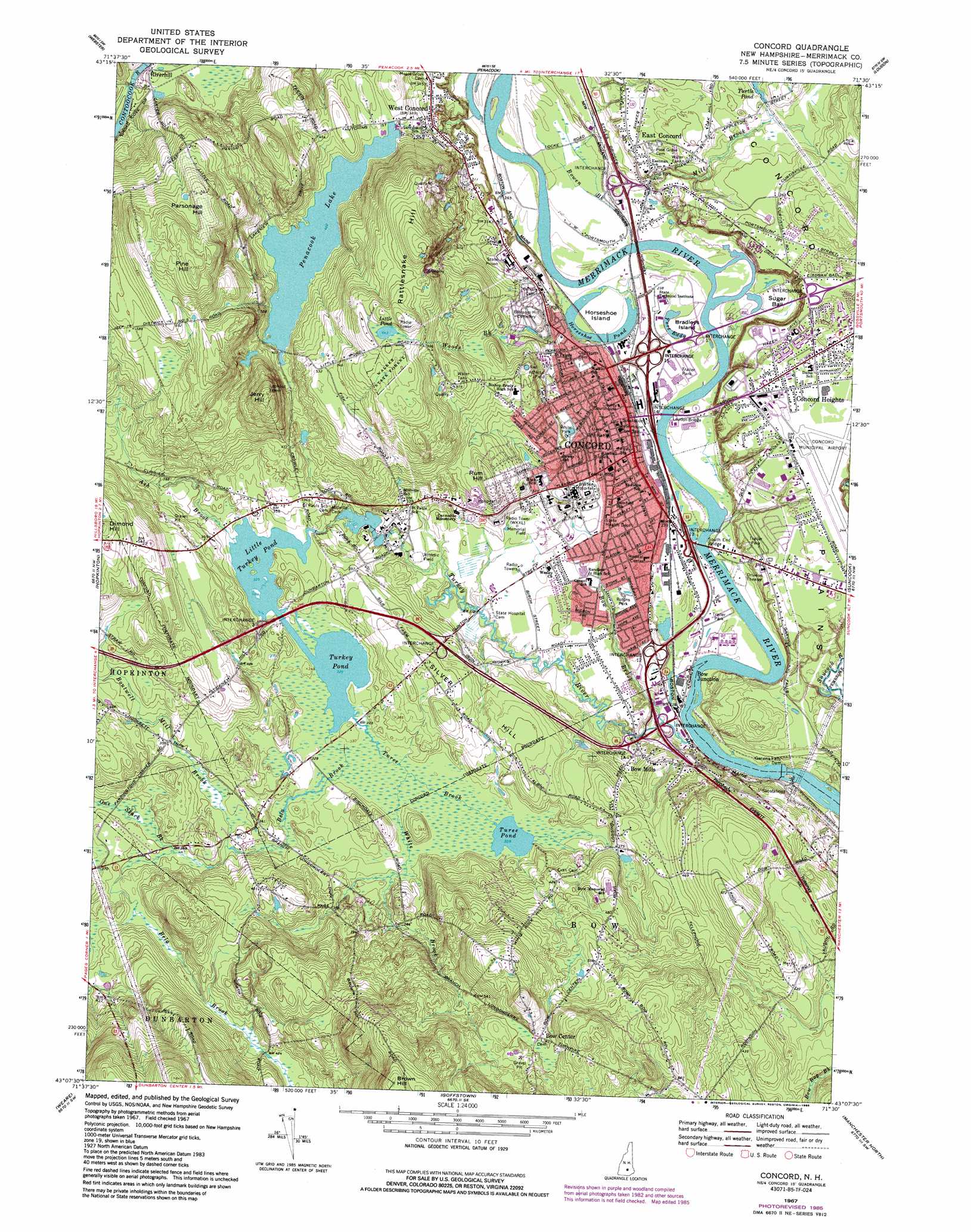
USGS Topo Quad 43071b5 - 1:24,000 scale
| Topo Map Name: | Concord |
| USGS Topo Quad ID: | 43071b5 |
| Print Size: | ca. 21 1/4" wide x 27" high |
| Southeast Coordinates: | 43.125° N latitude / 71.5° W longitude |
| Map Center Coordinates: | 43.1875° N latitude / 71.5625° W longitude |
| U.S. State: | NH |
| Filename: | o43071b5.jpg |
| Download Map JPG Image: | Concord topo map 1:24,000 scale |
| Map Type: | Topographic |
| Topo Series: | 7.5´ |
| Map Scale: | 1:24,000 |
| Source of Map Images: | United States Geological Survey (USGS) |
| Alternate Map Versions: |
Concord NH 1967, updated 1971 Download PDF Buy paper map Concord NH 1967, updated 1985 Download PDF Buy paper map Concord NH 1967, updated 1985 Download PDF Buy paper map Concord NH 2012 Download PDF Buy paper map Concord NH 2015 Download PDF Buy paper map |
1:24,000 Topo Quads surrounding Concord
Andover |
Franklin |
Northfield |
Belmont |
Gilmanton Ironworks |
Warner |
Webster |
Penacook |
Loudon |
Pittsfield |
Henniker |
Hopkinton |
Concord |
Suncook |
Gossville |
Deering |
Weare |
Goffstown |
Manchester North |
Candia |
Greenfield |
New Boston |
Pinardville |
Manchester South |
Derry |
> Back to 43071a1 at 1:100,000 scale
> Back to 43070a1 at 1:250,000 scale
> Back to U.S. Topo Maps home
Concord topo map: Gazetteer
Concord: Airports
Canterbury Heliport elevation 105m 344′Concord Hospital Heliport elevation 118m 387′
Concord Municipal Airport elevation 102m 334′
Concord: Basins
Sugar Ball elevation 70m 229′Concord: Bridges
Loudon Bridge elevation 67m 219′South End Bridge elevation 67m 219′
Concord: Crossings
Interchange 1 elevation 86m 282′Interchange 12 elevation 82m 269′
Interchange 13 elevation 73m 239′
Interchange 14 elevation 74m 242′
Interchange 15 elevation 73m 239′
Interchange 16 elevation 73m 239′
Interchange 1A elevation 86m 282′
Interchange 2 elevation 113m 370′
Interchange 3 elevation 112m 367′
Concord: Dams
Concord Water Works Dam elevation 122m 400′Garvins Falls Dam elevation 65m 213′
Lower School Pond Dam elevation 100m 328′
Saint Pauls School Dam elevation 99m 324′
Concord: Falls
Garvin Falls elevation 65m 213′Concord: Flats
Concord Plains elevation 109m 357′Concord: Forests
Walker State Forest elevation 188m 616′Concord: Islands
Bradleys Island elevation 70m 229′Horseshoe Island elevation 70m 229′
Concord: Lakes
Fort Eddy elevation 70m 229′Horseshoe Pond elevation 70m 229′
Little Pond elevation 196m 643′
Turee Pond elevation 100m 328′
Turkey Pond elevation 99m 324′
Concord: Mines
Concord Granite Quarries elevation 203m 666′Concord: Parks
Concord Civic District elevation 86m 282′Concord Historic District elevation 77m 252′
Garrison Park elevation 115m 377′
Grappone Park elevation 94m 308′
Heights Playground elevation 105m 344′
Kimball Park elevation 90m 295′
Memorial Field elevation 91m 298′
New Hampshire Hospital Grounds elevation 97m 318′
Reed Playground elevation 72m 236′
Rollins Park elevation 85m 278′
Sanel Park elevation 100m 328′
State House Plaza elevation 84m 275′
West Street Playground elevation 86m 282′
White Park elevation 110m 360′
Concord: Populated Places
Bow Center elevation 183m 600′Bow Junction elevation 74m 242′
Bow Mills elevation 89m 291′
Concord elevation 83m 272′
Concord Heights elevation 104m 341′
East Concord elevation 95m 311′
Riverhill elevation 108m 354′
West Concord elevation 110m 360′
Concord: Post Offices
Concord Post Office elevation 87m 285′Saint Pauls School Post Office (historical) elevation 101m 331′
Concord: Reservoirs
Bow Town Pond elevation 115m 377′Little Turkey Pond elevation 99m 324′
Lower School Pond elevation 100m 328′
Penacook Lake elevation 122m 400′
Concord: Streams
Ash Brook elevation 99m 324′Bela Brook elevation 100m 328′
Boutwell Mill Brook elevation 102m 334′
Bow Brook elevation 68m 223′
Bowen Brook elevation 71m 232′
Mill Brook elevation 67m 219′
One Stack Brook elevation 106m 347′
Turee Brook elevation 99m 324′
Turkey River elevation 68m 223′
White Brook elevation 100m 328′
Woods Brook elevation 83m 272′
Concord: Summits
Jerry Hill elevation 218m 715′Parsonage Hill elevation 221m 725′
Pine Hill elevation 239m 784′
Rattlesnake Hill elevation 225m 738′
Rum Hill elevation 132m 433′
Silver Hill elevation 129m 423′
Concord digital topo map on disk
Buy this Concord topo map showing relief, roads, GPS coordinates and other geographical features, as a high-resolution digital map file on DVD:
Maine, New Hampshire, Rhode Island & Eastern Massachusetts
Buy digital topo maps: Maine, New Hampshire, Rhode Island & Eastern Massachusetts