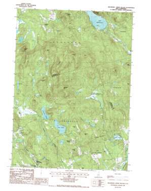
Hillsboro Upper Village Topo Map New Hampshire
To zoom in, hover over the map of Hillsboro Upper Village
USGS Topo Quad 43071b8 - 1:24,000 scale
| Topo Map Name: | Hillsboro Upper Village |
| USGS Topo Quad ID: | 43071b8 |
| Print Size: | ca. 21 1/4" wide x 27" high |
| Southeast Coordinates: | 43.125° N latitude / 71.875° W longitude |
| Map Center Coordinates: | 43.1875° N latitude / 71.9375° W longitude |
| U.S. State: | NH |
| Filename: | o43071b8.jpg |
| Download Map JPG Image: | Hillsboro Upper Village topo map 1:24,000 scale |
| Map Type: | Topographic |
| Topo Series: | 7.5´ |
| Map Scale: | 1:24,000 |
| Source of Map Images: | United States Geological Survey (USGS) |
| Alternate Map Versions: |
Hillsboro Upper Village NH 1987, updated 1987 Download PDF Buy paper map Hillsboro Upper Village NH 1998, updated 2001 Download PDF Buy paper map Hillsboro Upper Village NH 2012 Download PDF Buy paper map Hillsboro Upper Village NH 2015 Download PDF Buy paper map |
1:24,000 Topo Quads surrounding Hillsboro Upper Village
> Back to 43071a1 at 1:100,000 scale
> Back to 43070a1 at 1:250,000 scale
> Back to U.S. Topo Maps home
Hillsboro Upper Village topo map: Gazetteer
Hillsboro Upper Village: Dams
Lake Franklin Pierce Dam elevation 286m 938′Sand Brook Marsh Dam elevation 288m 944′
Hillsboro Upper Village: Forests
Fox State Forest elevation 218m 715′Hillsboro Upper Village: Lakes
Carter Pond elevation 295m 967′Contention Pond elevation 266m 872′
Day Pond elevation 211m 692′
Gould Pond elevation 189m 620′
Lake Massasecum elevation 193m 633′
Mud Pond elevation 279m 915′
Mud Pond elevation 206m 675′
Hillsboro Upper Village: Parks
Farrar Marsh State Wildlife Management Area elevation 273m 895′Hillsboro Upper Village: Populated Places
Bradford Center elevation 262m 859′Hillsboro Center elevation 323m 1059′
Hillsboro Upper Village elevation 292m 958′
Hillsboro Upper Village: Reservoirs
Loon Pond elevation 300m 984′Sand Brook Marsh elevation 288m 944′
Hillsboro Upper Village: Streams
Black Pond Brook elevation 263m 862′Nelson Brook elevation 208m 682′
Sand Brook elevation 167m 547′
Hillsboro Upper Village: Summits
Colby Hill elevation 379m 1243′Goodwin Hill elevation 392m 1286′
Guild Hill elevation 329m 1079′
Kimball Hill elevation 386m 1266′
Knights Hill elevation 572m 1876′
Monroe Hill elevation 352m 1154′
Mount Misery elevation 321m 1053′
Murdough Hill elevation 405m 1328′
Peaked Hill elevation 311m 1020′
Pickett Hill elevation 414m 1358′
Rowes Hill elevation 525m 1722′
Silver Hill elevation 498m 1633′
Thompson Hill elevation 538m 1765′
Hillsboro Upper Village digital topo map on disk
Buy this Hillsboro Upper Village topo map showing relief, roads, GPS coordinates and other geographical features, as a high-resolution digital map file on DVD:
Maine, New Hampshire, Rhode Island & Eastern Massachusetts
Buy digital topo maps: Maine, New Hampshire, Rhode Island & Eastern Massachusetts


