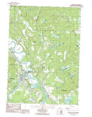
Penacook Topo Map New Hampshire
To zoom in, hover over the map of Penacook
USGS Topo Quad 43071c5 - 1:24,000 scale
| Topo Map Name: | Penacook |
| USGS Topo Quad ID: | 43071c5 |
| Print Size: | ca. 21 1/4" wide x 27" high |
| Southeast Coordinates: | 43.25° N latitude / 71.5° W longitude |
| Map Center Coordinates: | 43.3125° N latitude / 71.5625° W longitude |
| U.S. State: | NH |
| Filename: | o43071c5.jpg |
| Download Map JPG Image: | Penacook topo map 1:24,000 scale |
| Map Type: | Topographic |
| Topo Series: | 7.5´ |
| Map Scale: | 1:24,000 |
| Source of Map Images: | United States Geological Survey (USGS) |
| Alternate Map Versions: |
Penacook NH 1987, updated 1987 Download PDF Buy paper map Penacook NH 2012 Download PDF Buy paper map Penacook NH 2015 Download PDF Buy paper map |
1:24,000 Topo Quads surrounding Penacook
> Back to 43071a1 at 1:100,000 scale
> Back to 43070a1 at 1:250,000 scale
> Back to U.S. Topo Maps home
Penacook topo map: Gazetteer
Penacook: Capes
Goodwin Point elevation 78m 255′Penacook: Crossings
Interchange 17 elevation 102m 334′Interchange 18 elevation 115m 377′
Penacook: Dams
Briar Pipe Dam elevation 99m 324′Briar Pipe Dam On The Branch elevation 99m 324′
Edward H York Dam elevation 101m 331′
Fifield Farm Pond Dam elevation 154m 505′
Hoit Road Marsh Dam elevation 127m 416′
Sewalls Falls Dam elevation 75m 246′
Turtle Pond Dam elevation 96m 314′
Penacook: Falls
Sewalls Falls elevation 73m 239′Penacook: Flats
Spender Meadow elevation 162m 531′Penacook: Lakes
Crane Neck Pond elevation 169m 554′Horseshoe Pond elevation 143m 469′
Hothole Pond elevation 151m 495′
Kimball Pond elevation 145m 475′
Morrill Pond elevation 253m 830′
Morrill Pond elevation 152m 498′
Snow Pond elevation 113m 370′
Spender Pond elevation 162m 531′
Penacook: Parks
Contoocook Park elevation 108m 354′Hannah Dustin Historical Site elevation 77m 252′
Holt Road Marsh State Wildlife Manangement Area elevation 127m 416′
Rolfe Park elevation 112m 367′
Rolfe Park elevation 112m 367′
Penacook: Populated Places
Boscawen elevation 97m 318′Boyce elevation 103m 337′
Canterbury elevation 178m 583′
Canterbury Station elevation 111m 364′
Concord Manor elevation 111m 364′
Kezer Seminary elevation 170m 557′
Penacook elevation 101m 331′
Penacook: Post Offices
Canterbury Post Office elevation 182m 597′Penacook: Reservoirs
Contoocook River Reservoir elevation 101m 331′Fifield Farm Pond elevation 154m 505′
Hoit Road Marsh elevation 127m 416′
Merrimack River Reservoir elevation 75m 246′
Turtle Pond elevation 96m 314′
Penacook: Streams
Beaver Meadow Brook elevation 72m 236′Burnham Brook elevation 73m 239′
Cold Brook elevation 76m 249′
Contoocook River elevation 73m 239′
Davis Brook elevation 152m 498′
Forest Pond Brook elevation 129m 423′
Hackett Brook elevation 112m 367′
Hayward Brook elevation 82m 269′
Hazleton Brook elevation 130m 426′
Hoyl Brook elevation 76m 249′
Tannery Brook elevation 73m 239′
Penacook: Summits
Cogswell Hill elevation 211m 692′Dagody Hill elevation 174m 570′
Oak Hill elevation 293m 961′
Whitney Hill elevation 219m 718′
Zion Hill elevation 277m 908′
Penacook: Swamps
Big Meadows elevation 132m 433′Holt Road Marsh elevation 127m 416′
Penacook digital topo map on disk
Buy this Penacook topo map showing relief, roads, GPS coordinates and other geographical features, as a high-resolution digital map file on DVD:
Maine, New Hampshire, Rhode Island & Eastern Massachusetts
Buy digital topo maps: Maine, New Hampshire, Rhode Island & Eastern Massachusetts


