Belmont Topo Map New Hampshire
To zoom in, hover over the map of Belmont
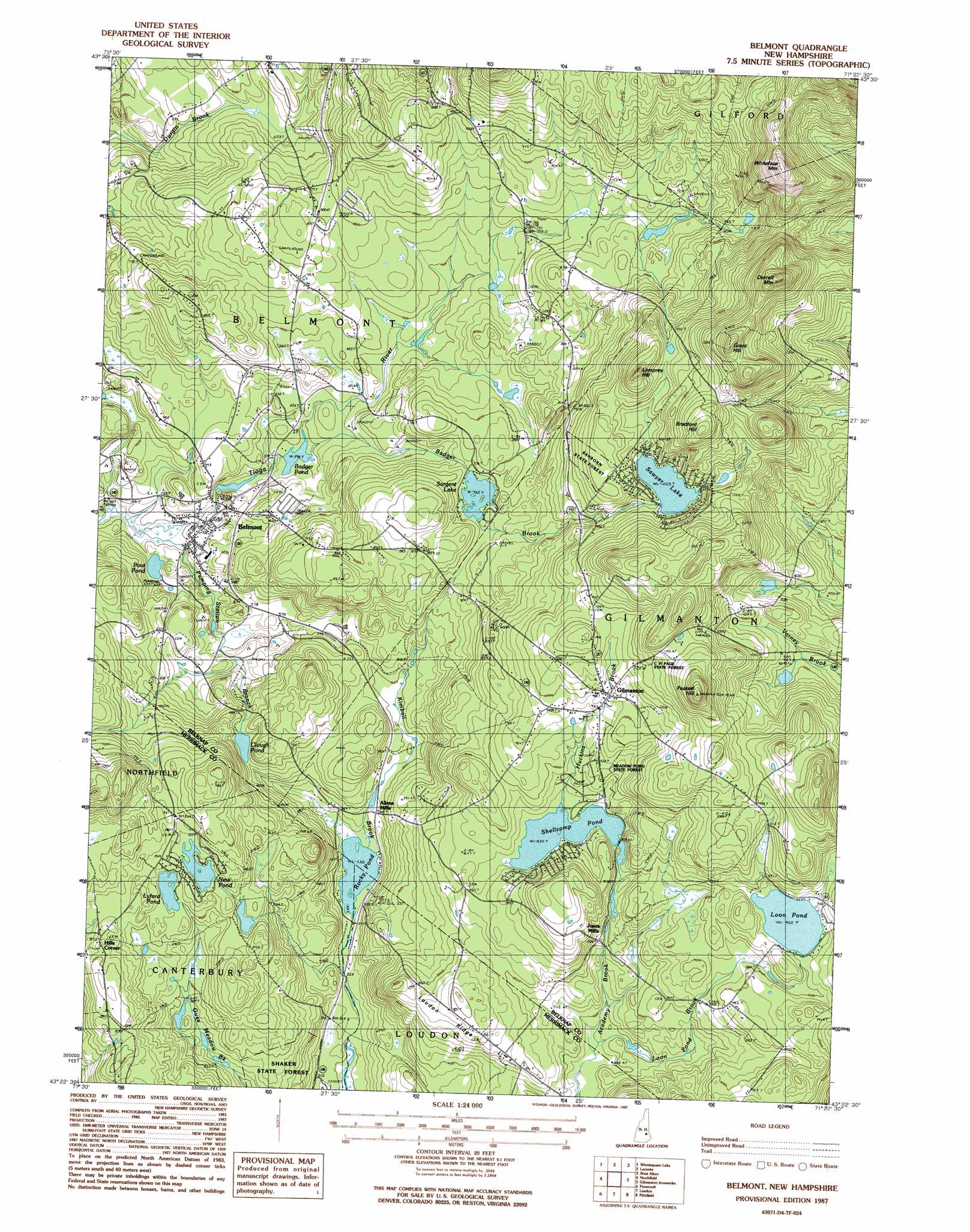
USGS Topo Quad 43071d4 - 1:24,000 scale
| Topo Map Name: | Belmont |
| USGS Topo Quad ID: | 43071d4 |
| Print Size: | ca. 21 1/4" wide x 27" high |
| Southeast Coordinates: | 43.375° N latitude / 71.375° W longitude |
| Map Center Coordinates: | 43.4375° N latitude / 71.4375° W longitude |
| U.S. State: | NH |
| Filename: | o43071d4.jpg |
| Download Map JPG Image: | Belmont topo map 1:24,000 scale |
| Map Type: | Topographic |
| Topo Series: | 7.5´ |
| Map Scale: | 1:24,000 |
| Source of Map Images: | United States Geological Survey (USGS) |
| Alternate Map Versions: |
Belmont NH 1987, updated 1987 Download PDF Buy paper map Belmont NH 2012 Download PDF Buy paper map Belmont NH 2015 Download PDF Buy paper map |
1:24,000 Topo Quads surrounding Belmont
Ashland |
Holderness |
Center Harbor |
Melvin Village |
Tuftonboro |
Bristol |
Winnisquam Lake |
Laconia |
West Alton |
Wolfeboro |
Franklin |
Northfield |
Belmont |
Gilmanton Ironworks |
Alton |
Webster |
Penacook |
Loudon |
Pittsfield |
Parker Mountain |
Hopkinton |
Concord |
Suncook |
Gossville |
Northwood |
> Back to 43071a1 at 1:100,000 scale
> Back to 43070a1 at 1:250,000 scale
> Back to U.S. Topo Maps home
Belmont topo map: Gazetteer
Belmont: Dams
Badger Pond Dam elevation 179m 587′Bean Dam elevation 212m 695′
Lyford Pond Dike elevation 248m 813′
Sargent Lake Dam elevation 235m 770′
Sawyer Lake Dam elevation 315m 1033′
Shellcamp Pond Dam elevation 254m 833′
Tioga River Dam elevation 168m 551′
Belmont: Forests
C H Page State Forest elevation 343m 1125′Meadow Pond State Forest elevation 289m 948′
Shaker State Forest elevation 202m 662′
Belmont: Lakes
Badger Pond elevation 179m 587′Clough Pond elevation 206m 675′
Loon Pond elevation 279m 915′
New Pond elevation 254m 833′
Pout Pond elevation 156m 511′
Rocky Pond elevation 161m 528′
Belmont: Populated Places
Allens Mills elevation 175m 574′Belmont elevation 166m 544′
Gilmanton elevation 303m 994′
Hills Corner elevation 266m 872′
Jones Mills elevation 256m 839′
Belmont: Reservoirs
Lyford Pond elevation 248m 813′Sargent Lake elevation 235m 770′
Sawyer Lake elevation 315m 1033′
Shellcamp Pond elevation 254m 833′
Tioga River Reservoir elevation 212m 695′
Tioga River Reservoir elevation 168m 551′
Belmont: Ridges
Loudon Ridge elevation 247m 810′Belmont: Streams
Badger Brook elevation 179m 587′Kimball Brook elevation 161m 528′
Loon Pond Brook elevation 204m 669′
Pumping Station Branch elevation 149m 488′
Belmont: Summits
Bradford Hill elevation 416m 1364′Grant Hill elevation 459m 1505′
Lamprey Hill elevation 397m 1302′
Peaked Hill elevation 443m 1453′
Whiteface Mountain elevation 477m 1564′
Belmont digital topo map on disk
Buy this Belmont topo map showing relief, roads, GPS coordinates and other geographical features, as a high-resolution digital map file on DVD:
Maine, New Hampshire, Rhode Island & Eastern Massachusetts
Buy digital topo maps: Maine, New Hampshire, Rhode Island & Eastern Massachusetts