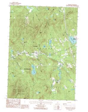
Andover Topo Map New Hampshire
To zoom in, hover over the map of Andover
USGS Topo Quad 43071d7 - 1:24,000 scale
| Topo Map Name: | Andover |
| USGS Topo Quad ID: | 43071d7 |
| Print Size: | ca. 21 1/4" wide x 27" high |
| Southeast Coordinates: | 43.375° N latitude / 71.75° W longitude |
| Map Center Coordinates: | 43.4375° N latitude / 71.8125° W longitude |
| U.S. State: | NH |
| Filename: | o43071d7.jpg |
| Download Map JPG Image: | Andover topo map 1:24,000 scale |
| Map Type: | Topographic |
| Topo Series: | 7.5´ |
| Map Scale: | 1:24,000 |
| Source of Map Images: | United States Geological Survey (USGS) |
| Alternate Map Versions: |
Andover NH 1987, updated 1987 Download PDF Buy paper map Andover NH 1998, updated 2001 Download PDF Buy paper map Andover NH 2012 Download PDF Buy paper map Andover NH 2015 Download PDF Buy paper map |
1:24,000 Topo Quads surrounding Andover
> Back to 43071a1 at 1:100,000 scale
> Back to 43070a1 at 1:250,000 scale
> Back to U.S. Topo Maps home
Andover topo map: Gazetteer
Andover: Bridges
Cilleyville Bridge elevation 200m 656′Keniston Bridge elevation 189m 620′
Andover: Dams
Bradley Lake Dam elevation 261m 856′Johnson Mill Dam elevation 199m 652′
Morey Pond Dam elevation 405m 1328′
Andover: Forests
Ragged Mountain State Forest elevation 197m 646′Andover: Lakes
Adder Pond elevation 200m 656′Bog Pond elevation 199m 652′
Cold Pond elevation 333m 1092′
Elbow Pond elevation 188m 616′
Horseshoe Pond elevation 187m 613′
Huntoon Pond elevation 339m 1112′
March Pond elevation 345m 1131′
Mud Pond elevation 327m 1072′
The Bay elevation 182m 597′
Wilder Pond elevation 328m 1076′
Andover: Parks
Mount Kearsarge State Forest Park elevation 751m 2463′Mount Kearsarge State Wildlife Management Area elevation 288m 944′
Andover: Populated Places
Andover elevation 197m 646′Cilleyville elevation 195m 639′
Potter Place elevation 196m 643′
West Salisbury elevation 200m 656′
Andover: Post Offices
Andover Post Office elevation 196m 643′Andover: Reservoirs
Bradley Lake elevation 261m 856′Morey Pond elevation 405m 1328′
Andover: Ridges
Buswell Ridges elevation 530m 1738′Andover: Streams
Bradley Brook elevation 251m 823′Cascade Brook elevation 199m 652′
Frazier Brook elevation 199m 652′
Gulf Brook elevation 250m 820′
Hameshop Brook elevation 187m 613′
Mitchell Brook elevation 186m 610′
Mountain Brook elevation 194m 636′
Mountain Brook elevation 184m 603′
Tilton Brook elevation 201m 659′
Andover: Summits
Beech Hill elevation 424m 1391′Boston Hill elevation 288m 944′
Little Mountain elevation 711m 2332′
Lovering Hill elevation 289m 948′
March Hill elevation 468m 1535′
Morey Hill elevation 437m 1433′
Mount Kearsarge elevation 892m 2926′
Raccoon Hill elevation 358m 1174′
Ragged Mountain elevation 690m 2263′
Ragged Mountains elevation 577m 1893′
Taunton Hill elevation 346m 1135′
The Bulkhead elevation 527m 1729′
The Pinnacle elevation 688m 2257′
Tucker Mountain elevation 497m 1630′
Andover: Trails
Wilmot Trail elevation 622m 2040′Andover digital topo map on disk
Buy this Andover topo map showing relief, roads, GPS coordinates and other geographical features, as a high-resolution digital map file on DVD:
Maine, New Hampshire, Rhode Island & Eastern Massachusetts
Buy digital topo maps: Maine, New Hampshire, Rhode Island & Eastern Massachusetts


