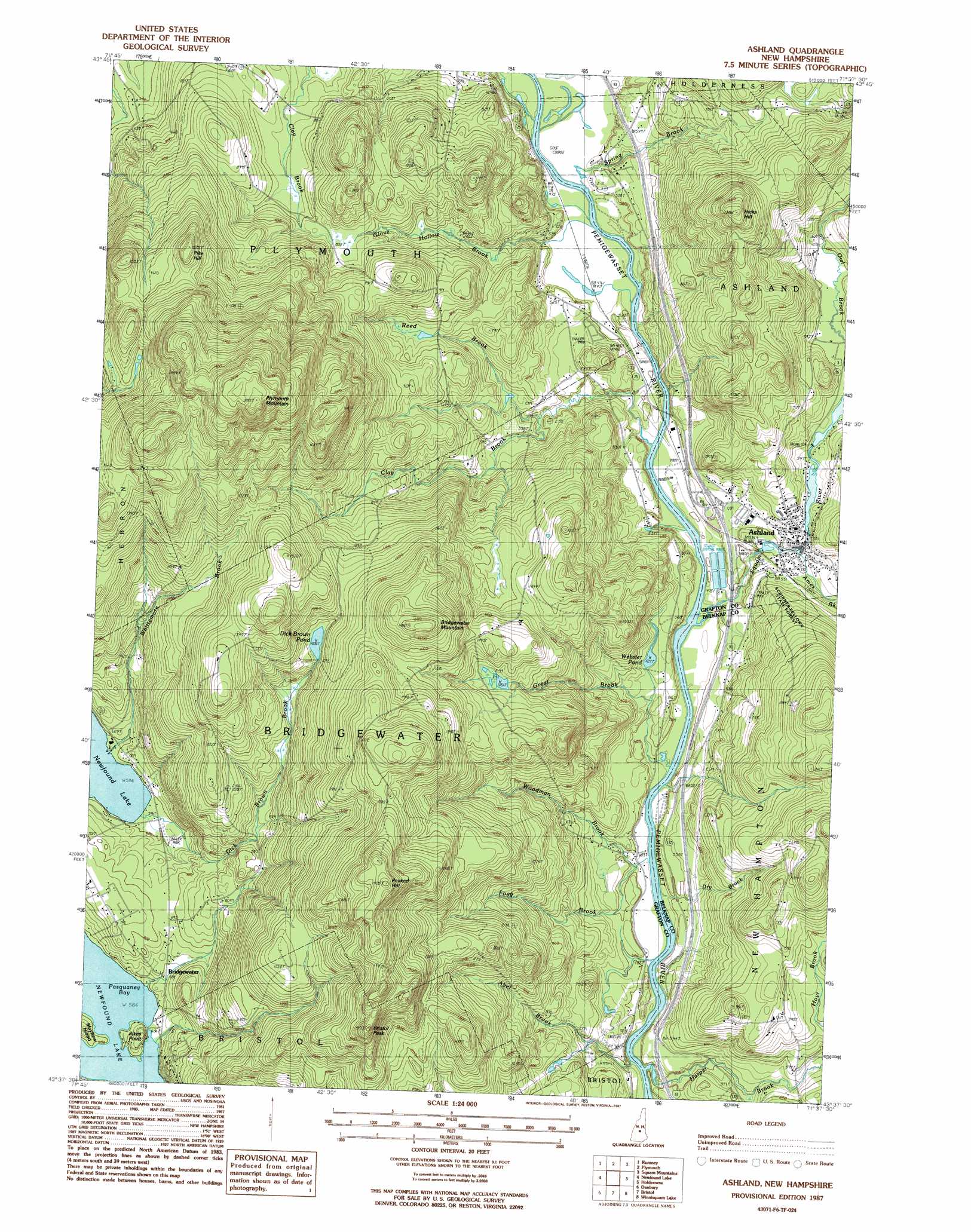
Ashland Topo Map New Hampshire
To zoom in, hover over the map of Ashland
USGS Topo Quad 43071f6 - 1:24,000 scale
| Topo Map Name: | Ashland |
| USGS Topo Quad ID: | 43071f6 |
| Print Size: | ca. 21 1/4" wide x 27" high |
| Southeast Coordinates: | 43.625° N latitude / 71.625° W longitude |
| Map Center Coordinates: | 43.6875° N latitude / 71.6875° W longitude |
| U.S. State: | NH |
| Filename: | o43071f6.jpg |
| Download Map JPG Image: | Ashland topo map 1:24,000 scale |
| Map Type: | Topographic |
| Topo Series: | 7.5´ |
| Map Scale: | 1:24,000 |
| Source of Map Images: | United States Geological Survey (USGS) |
| Alternate Map Versions: |
Ashland NH 1987, updated 1987 Download PDF Buy paper map Ashland NH 2000, updated 2001 Download PDF Buy paper map Ashland NH 2012 Download PDF Buy paper map Ashland NH 2015 Download PDF Buy paper map |
1:24,000 Topo Quads surrounding Ashland
Warren |
Mount Kineo |
Woodstock |
Waterville Valley |
Mount Tripyramid |
Wentworth |
Rumney |
Plymouth |
Squam Mountains |
Center Sandwich |
Mount Cardigan |
Newfound Lake |
Ashland |
Holderness |
Center Harbor |
Grafton |
Danbury |
Bristol |
Winnisquam Lake |
Laconia |
New London |
Andover |
Franklin |
Northfield |
Belmont |
> Back to 43071e1 at 1:100,000 scale
> Back to 43070a1 at 1:250,000 scale
> Back to U.S. Topo Maps home
Ashland topo map: Gazetteer
Ashland: Airports
Riverside Airport (historical) elevation 143m 469′Ashland: Capes
Pikes Point elevation 179m 587′Ashland: Crossings
Interchange 24 elevation 152m 498′Ashland: Dams
Ashland Mill Dam elevation 167m 547′Ashland Town Sewage Lagoon Dikes elevation 159m 521′
Dick Brown Pond Dam elevation 381m 1250′
Squam Lake Dam elevation 171m 561′
Ashland: Islands
Mayhew Island elevation 200m 656′Ashland: Lakes
Webster Pond elevation 161m 528′Ashland: Parks
Church Hill Wildlife Management Area elevation 153m 501′Scribner Fellows State Forest elevation 210m 688′
Ashland: Populated Places
Ashland elevation 168m 551′Bridgewater elevation 195m 639′
Ashland: Post Offices
Ashland Post Office elevation 174m 570′Ashland: Reservoirs
Ashland Town Sewage Lagoons elevation 159m 521′Dick Brown Pond elevation 381m 1250′
Grist Mill Pond elevation 167m 547′
Little Squam Lake elevation 171m 561′
Ashland: Streams
Abel Brook elevation 153m 501′Ames Brook elevation 159m 521′
Clay Brook elevation 142m 465′
Dick Brown Brook elevation 180m 590′
Dry Brook elevation 138m 452′
Fogg Brook elevation 140m 459′
Glove Hollow Brook elevation 140m 459′
Great Brook elevation 139m 456′
Harper Brook elevation 143m 469′
Reed Brook elevation 143m 469′
Spring Brook elevation 141m 462′
Squam River elevation 138m 452′
Whittemore Brook elevation 179m 587′
Woodman Brook elevation 140m 459′
Ashland: Summits
Bridgewater Mountain elevation 504m 1653′Bristol Peak elevation 548m 1797′
Hicks Hill elevation 422m 1384′
Peaked Hill elevation 575m 1886′
Pike Hill elevation 457m 1499′
Plymouth Mountain elevation 665m 2181′
Ashland digital topo map on disk
Buy this Ashland topo map showing relief, roads, GPS coordinates and other geographical features, as a high-resolution digital map file on DVD:
Maine, New Hampshire, Rhode Island & Eastern Massachusetts
Buy digital topo maps: Maine, New Hampshire, Rhode Island & Eastern Massachusetts