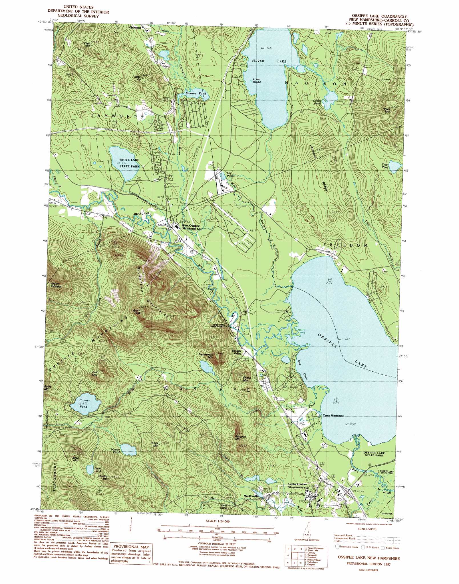
Ossipee Lake Topo Map New Hampshire
To zoom in, hover over the map of Ossipee Lake
USGS Topo Quad 43071g2 - 1:24,000 scale
| Topo Map Name: | Ossipee Lake |
| USGS Topo Quad ID: | 43071g2 |
| Print Size: | ca. 21 1/4" wide x 27" high |
| Southeast Coordinates: | 43.75° N latitude / 71.125° W longitude |
| Map Center Coordinates: | 43.8125° N latitude / 71.1875° W longitude |
| U.S. State: | NH |
| Filename: | o43071g2.jpg |
| Download Map JPG Image: | Ossipee Lake topo map 1:24,000 scale |
| Map Type: | Topographic |
| Topo Series: | 7.5´ |
| Map Scale: | 1:24,000 |
| Source of Map Images: | United States Geological Survey (USGS) |
| Alternate Map Versions: |
Ossipee Lake NH 1987, updated 1987 Download PDF Buy paper map Ossipee Lake NH 1998, updated 2001 Download PDF Buy paper map Ossipee Lake NH 2012 Download PDF Buy paper map Ossipee Lake NH 2015 Download PDF Buy paper map |
1:24,000 Topo Quads surrounding Ossipee Lake
Mount Carrigan |
Bartlett |
North Conway West |
North Conway East |
Fryeburg |
Mount Tripyramid |
Mount Chocorua |
Silver Lake |
Conway |
Brownfield |
Center Sandwich |
Tamworth |
Ossipee Lake |
Freedom |
Kezar Falls |
Center Harbor |
Melvin Village |
Tuftonboro |
Ossipee |
West Newfield |
Laconia |
West Alton |
Wolfeboro |
Sanbornville |
Great East Lake |
> Back to 43071e1 at 1:100,000 scale
> Back to 43070a1 at 1:250,000 scale
> Back to U.S. Topo Maps home
Ossipee Lake topo map: Gazetteer
Ossipee Lake: Airports
Meaders Heliport elevation 126m 413′White Mountain Gateway Airport elevation 136m 446′
Windsock Village Airport elevation 138m 452′
Ossipee Lake: Bays
Deer Cove elevation 125m 410′Ossipee Lake: Bridges
Whittier Bridge elevation 128m 419′Ossipee Lake: Dams
Dan Hole River Dam elevation 172m 564′Silver Lake Dam elevation 141m 462′
Ossipee Lake: Islands
Loon Island elevation 142m 465′Ossipee Lake: Lakes
Bean Pond elevation 405m 1328′Conner Pond elevation 274m 898′
Cooks Pond elevation 142m 465′
Lily Pond elevation 137m 449′
Moody Pond elevation 303m 994′
Moores Pond elevation 137m 449′
Ossipee Lake elevation 125m 410′
Trout Pond elevation 217m 711′
White Lake elevation 134m 439′
Ossipee Lake: Parks
White Lake State Park elevation 134m 439′Ossipee Lake: Populated Places
Center Ossipee elevation 159m 521′Dorrs Corner elevation 190m 623′
Moultonville elevation 160m 524′
Ossipee Valley elevation 126m 413′
West Ossipee elevation 132m 433′
Ossipee Lake: Post Offices
Center Ossipee Post Office elevation 158m 518′Ossipee Lake: Reservoirs
Dan Hole River Reservoir elevation 172m 564′Silver Lake elevation 142m 465′
Ossipee Lake: Ridges
Jackman Ridge elevation 214m 702′Nickerson Mountains elevation 453m 1486′
Raccoon Mountain elevation 302m 990′
Ossipee Lake: Streams
Bearcamp River elevation 125m 410′Beech River elevation 126m 413′
Chocorua River elevation 128m 419′
Deer Brook elevation 143m 469′
Folsom Brook elevation 125m 410′
Lovell River elevation 125m 410′
Mill Brook elevation 134m 439′
Pine River elevation 125m 410′
Stony Brook elevation 134m 439′
Swift River elevation 134m 439′
West Branch elevation 125m 410′
Ossipee Lake: Summits
Bean Mountain elevation 429m 1407′Grant Peak elevation 542m 1778′
Knox Mountain elevation 416m 1364′
Oak Mountain elevation 412m 1351′
Page Hill elevation 347m 1138′
Rattlesnake Mountain elevation 306m 1003′
Ryan Hill elevation 239m 784′
Sheep Mountain elevation 250m 820′
Stacy Mountain elevation 406m 1332′
Thurley Mountain elevation 503m 1650′
Ossipee Lake digital topo map on disk
Buy this Ossipee Lake topo map showing relief, roads, GPS coordinates and other geographical features, as a high-resolution digital map file on DVD:
Maine, New Hampshire, Rhode Island & Eastern Massachusetts
Buy digital topo maps: Maine, New Hampshire, Rhode Island & Eastern Massachusetts