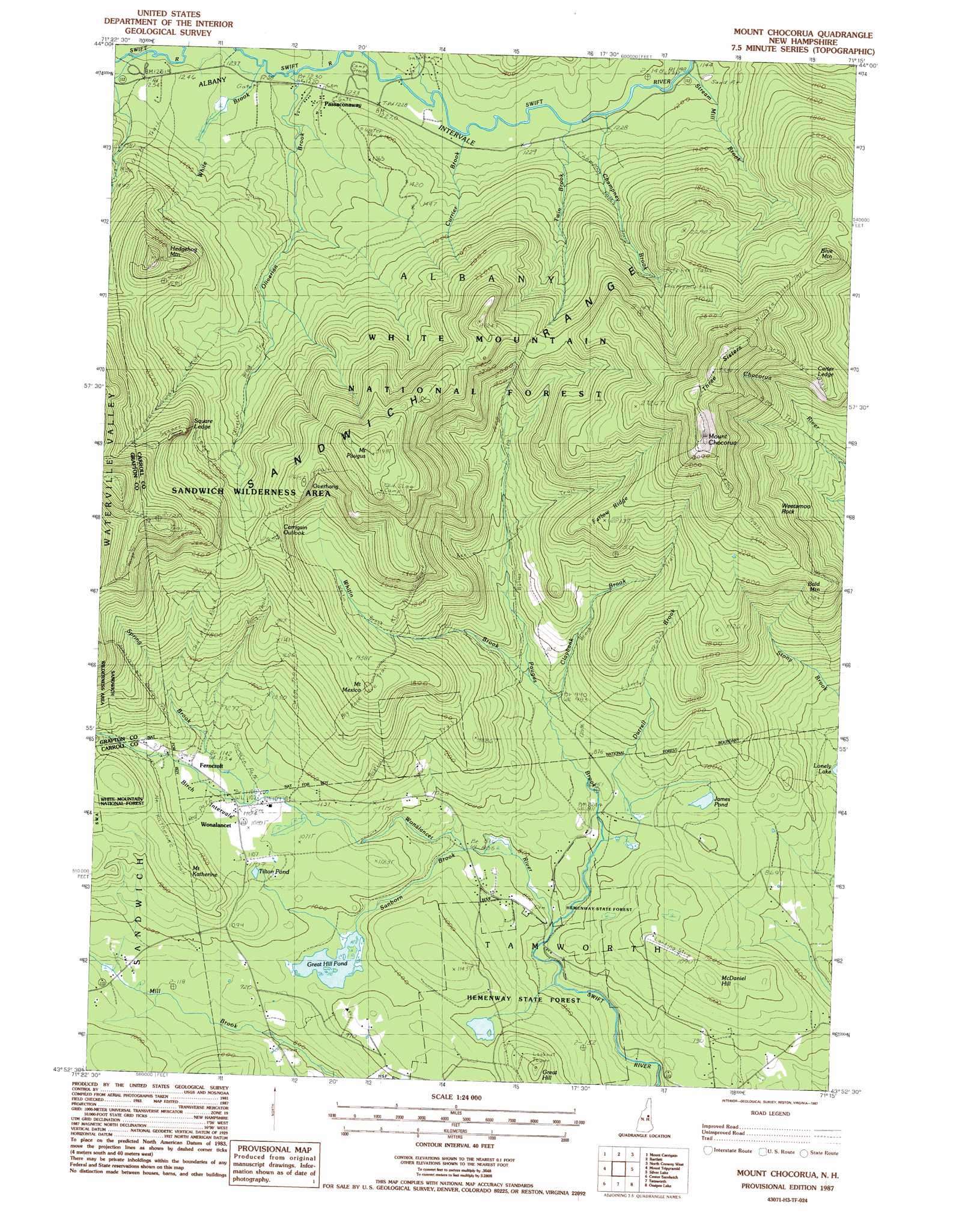
Mount Chocorua Topo Map New Hampshire
To zoom in, hover over the map of Mount Chocorua
USGS Topo Quad 43071h3 - 1:24,000 scale
| Topo Map Name: | Mount Chocorua |
| USGS Topo Quad ID: | 43071h3 |
| Print Size: | ca. 21 1/4" wide x 27" high |
| Southeast Coordinates: | 43.875° N latitude / 71.25° W longitude |
| Map Center Coordinates: | 43.9375° N latitude / 71.3125° W longitude |
| U.S. State: | NH |
| Filename: | o43071h3.jpg |
| Download Map JPG Image: | Mount Chocorua topo map 1:24,000 scale |
| Map Type: | Topographic |
| Topo Series: | 7.5´ |
| Map Scale: | 1:24,000 |
| Source of Map Images: | United States Geological Survey (USGS) |
| Alternate Map Versions: |
Mount Chocorua NH 1987, updated 1987 Download PDF Buy paper map Mount Chocorua NH 1995, updated 2000 Download PDF Buy paper map Mount Chocorua NH 2012 Download PDF Buy paper map Mount Chocorua NH 2015 Download PDF Buy paper map |
| FStopo: | US Forest Service topo Mount Chocorua is available: Download FStopo PDF Download FStopo TIF |
1:24,000 Topo Quads surrounding Mount Chocorua
South Twin Mountain |
Crawford Notch |
Stairs Mountain |
Jackson |
Chatham |
Mount Osceola |
Mount Carrigan |
Bartlett |
North Conway West |
North Conway East |
Waterville Valley |
Mount Tripyramid |
Mount Chocorua |
Silver Lake |
Conway |
Squam Mountains |
Center Sandwich |
Tamworth |
Ossipee Lake |
Freedom |
Holderness |
Center Harbor |
Melvin Village |
Tuftonboro |
Ossipee |
> Back to 43071e1 at 1:100,000 scale
> Back to 43070a1 at 1:250,000 scale
> Back to U.S. Topo Maps home
Mount Chocorua topo map: Gazetteer
Mount Chocorua: Basins
Birch Intervale elevation 340m 1115′Mount Chocorua: Benches
Carter Ledge elevation 702m 2303′Overhang elevation 753m 2470′
Square Ledge elevation 721m 2365′
Mount Chocorua: Lakes
James Pond elevation 274m 898′Moose Pond elevation 655m 2148′
Tilton Pond elevation 326m 1069′
Mount Chocorua: Parks
Mount Chocorua Scenic Area elevation 916m 3005′Mount Chocorua: Pillars
Weetamoo Rock elevation 755m 2477′Mount Chocorua: Populated Places
Ferncroft elevation 350m 1148′Passaconaway elevation 382m 1253′
Paugus Mill elevation 313m 1026′
Wonalancet elevation 335m 1099′
Mount Chocorua: Reservoirs
Great Hill Pond elevation 288m 944′Mount Chocorua: Ridges
Farlow Ridge elevation 673m 2208′Three Sisters elevation 987m 3238′
Whitin Ridge elevation 612m 2007′
Mount Chocorua: Streams
Champney Brook elevation 367m 1204′Claybank Brook elevation 291m 954′
Currier Brook elevation 371m 1217′
Douglas Brook elevation 375m 1230′
Downes Brook elevation 378m 1240′
Durrell Brook elevation 239m 784′
Kelly Brook elevation 353m 1158′
Oliveran Brook elevation 374m 1227′
Paugus Brook elevation 226m 741′
Sanborn Brook elevation 229m 751′
Spring Brook elevation 351m 1151′
Steam Mill Brook elevation 352m 1154′
Tewksberry Brook elevation 276m 905′
Twin Brook elevation 367m 1204′
White Brook elevation 377m 1236′
Whitin Brook elevation 302m 990′
Wonalancet River elevation 249m 816′
Mount Chocorua: Summits
Bald Mountain elevation 647m 2122′Blue Mountain elevation 737m 2417′
Great Hill elevation 381m 1250′
Hedgehog Mountain elevation 696m 2283′
Hibbard Mountain elevation 889m 2916′
McDaniel Hill elevation 356m 1167′
Mount Chocorua elevation 1060m 3477′
Mount Katherine elevation 418m 1371′
Mount Mexico elevation 611m 2004′
Mount Paugus elevation 946m 3103′
Mount Chocorua: Trails
Bee Line Trail elevation 513m 1683′Bickford Trail elevation 350m 1148′
Big Rock Cave Trail elevation 596m 1955′
Boles Trail elevation 675m 2214′
Cabin Trail elevation 445m 1459′
Champney Falls Trail elevation 522m 1712′
Chocorua Brook Trail elevation 430m 1410′
Falls Trail elevation 515m 1689′
Gordon Path elevation 341m 1118′
Hammond Trail elevation 541m 1774′
Kelley Trail elevation 515m 1689′
Lawrence Trail elevation 641m 2103′
Liberty Trail elevation 761m 2496′
Mexico Ridge Trail elevation 644m 2112′
Middle Sister Trail elevation 748m 2454′
Mount Katherine Trail elevation 403m 1322′
Mount Paugus Trail elevation 712m 2335′
Old Locke Road Path elevation 312m 1023′
Old Mast Road elevation 688m 2257′
Oliverian Brook Trail elevation 458m 1502′
Passaconaway Cutoff Trail elevation 531m 1742′
Red Path elevation 340m 1115′
Square Ledge Trail elevation 622m 2040′
U.N.H. Trail elevation 559m 1833′
Walden Trail elevation 912m 2992′
Whitin Brook Trail elevation 512m 1679′
Wona Lancet Range Trail elevation 721m 2365′
Wonalancet Range Trail elevation 711m 2332′
Mount Chocorua: Valleys
Albany Intervale elevation 352m 1154′Mount Chocorua digital topo map on disk
Buy this Mount Chocorua topo map showing relief, roads, GPS coordinates and other geographical features, as a high-resolution digital map file on DVD:
Maine, New Hampshire, Rhode Island & Eastern Massachusetts
Buy digital topo maps: Maine, New Hampshire, Rhode Island & Eastern Massachusetts