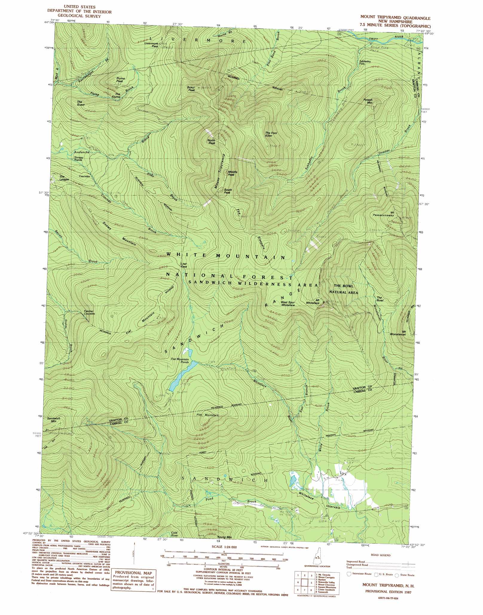
Mount Tripyramid Topo Map New Hampshire
To zoom in, hover over the map of Mount Tripyramid
USGS Topo Quad 43071h4 - 1:24,000 scale
| Topo Map Name: | Mount Tripyramid |
| USGS Topo Quad ID: | 43071h4 |
| Print Size: | ca. 21 1/4" wide x 27" high |
| Southeast Coordinates: | 43.875° N latitude / 71.375° W longitude |
| Map Center Coordinates: | 43.9375° N latitude / 71.4375° W longitude |
| U.S. State: | NH |
| Filename: | o43071h4.jpg |
| Download Map JPG Image: | Mount Tripyramid topo map 1:24,000 scale |
| Map Type: | Topographic |
| Topo Series: | 7.5´ |
| Map Scale: | 1:24,000 |
| Source of Map Images: | United States Geological Survey (USGS) |
| Alternate Map Versions: |
Mount Tripyramid NH 1987, updated 1987 Download PDF Buy paper map Mount Tripyramid NH 1995, updated 2000 Download PDF Buy paper map Mount Tripyramid NH 2012 Download PDF Buy paper map Mount Tripyramid NH 2015 Download PDF Buy paper map |
| FStopo: | US Forest Service topo Mount Tripyramid is available: Download FStopo PDF Download FStopo TIF |
1:24,000 Topo Quads surrounding Mount Tripyramid
Franconia |
South Twin Mountain |
Crawford Notch |
Stairs Mountain |
Jackson |
Lincoln |
Mount Osceola |
Mount Carrigan |
Bartlett |
North Conway West |
Woodstock |
Waterville Valley |
Mount Tripyramid |
Mount Chocorua |
Silver Lake |
Plymouth |
Squam Mountains |
Center Sandwich |
Tamworth |
Ossipee Lake |
Ashland |
Holderness |
Center Harbor |
Melvin Village |
Tuftonboro |
> Back to 43071e1 at 1:100,000 scale
> Back to 43070a1 at 1:250,000 scale
> Back to U.S. Topo Maps home
Mount Tripyramid topo map: Gazetteer
Mount Tripyramid: Basins
The Bowl elevation 661m 2168′Whiteface Intervale elevation 294m 964′
Mount Tripyramid: Benches
The Ledges elevation 631m 2070′Mount Tripyramid: Falls
Fletcher Cascades elevation 641m 2103′Norway Rapids elevation 535m 1755′
Sabbaday Falls elevation 428m 1404′
Mount Tripyramid: Gaps
Livermore Pass elevation 883m 2896′Lost Pass elevation 856m 2808′
Mount Tripyramid: Lakes
Flat Mountain Ponds elevation 713m 2339′Mount Tripyramid: Parks
The Bowl Natural Area elevation 838m 2749′Mount Tripyramid: Populated Places
Waterville Valley elevation 459m 1505′Mount Tripyramid: Ranges
Sandwich Range elevation 978m 3208′Mount Tripyramid: Ridges
Flat Mountain elevation 979m 3211′Snows Mountain elevation 818m 2683′
West Spur Whiteface elevation 1086m 3562′
Mount Tripyramid: Streams
Avalanche Brook elevation 508m 1666′Captain Neal Brook elevation 287m 941′
Cold Brook elevation 685m 2247′
Cold River elevation 310m 1017′
Drakes Brook elevation 484m 1587′
East Branch Whiteface River elevation 430m 1410′
Flume Brook elevation 559m 1833′
Greeley Brook elevation 578m 1896′
Kancamagus Brook elevation 611m 2004′
Sabbaday Brook elevation 405m 1328′
Slide Brook elevation 596m 1955′
White Brook elevation 295m 967′
Mount Tripyramid: Summits
Flat Mountain elevation 886m 2906′Flume Peak elevation 900m 2952′
Middle Peak elevation 1220m 4002′
Mount Passaconaway elevation 1225m 4019′
Mount Tripyramid elevation 1179m 3868′
Mount Whiteface elevation 1217m 3992′
Mount Wonalancet elevation 845m 2772′
North Peak elevation 1253m 4110′
Potash Mountain elevation 812m 2664′
Sandwich Dome elevation 1206m 3956′
Sandwich Mountain elevation 1215m 3986′
Scaur Peak elevation 1087m 3566′
South Peak elevation 1237m 4058′
The Fool Killer elevation 1064m 3490′
The Scaur elevation 648m 2125′
The Sleepers elevation 1177m 3861′
Young Mountain elevation 577m 1893′
Mount Tripyramid: Trails
Bennet ST Trail elevation 826m 2709′Blueberry Ledge Trail elevation 710m 2329′
Dicey Mill Trail elevation 621m 2037′
Downes Brook Trail elevation 652m 2139′
Drakes Brook Trail elevation 587m 1925′
Flat Mountain Pond Trail elevation 550m 1804′
Gleason Trail elevation 823m 2700′
Kettles Path elevation 570m 1870′
McCrills Trail elevation 718m 2355′
North Slide elevation 921m 3021′
Pine Bend Brook Trail elevation 917m 3008′
Pyramid Loop Trail elevation 737m 2417′
Rollins Trail elevation 993m 3257′
Sabbaday Brook Trail elevation 605m 1984′
Sandwich Mountain Trail elevation 1108m 3635′
Scaur Trail elevation 642m 2106′
Sleeper Trail elevation 1117m 3664′
Slide Trail elevation 812m 2664′
Slides Downes Brook Trail elevation 741m 2431′
Snow Mountain Trail elevation 663m 2175′
Snows Brook Trail elevation 652m 2139′
South Slide elevation 1017m 3336′
Wigg Trail elevation 751m 2463′
Woodbury Trail elevation 733m 2404′
Mount Tripyramid digital topo map on disk
Buy this Mount Tripyramid topo map showing relief, roads, GPS coordinates and other geographical features, as a high-resolution digital map file on DVD:
Maine, New Hampshire, Rhode Island & Eastern Massachusetts
Buy digital topo maps: Maine, New Hampshire, Rhode Island & Eastern Massachusetts