Sunapee Lakes Topo Map New Hampshire
To zoom in, hover over the map of Sunapee Lakes
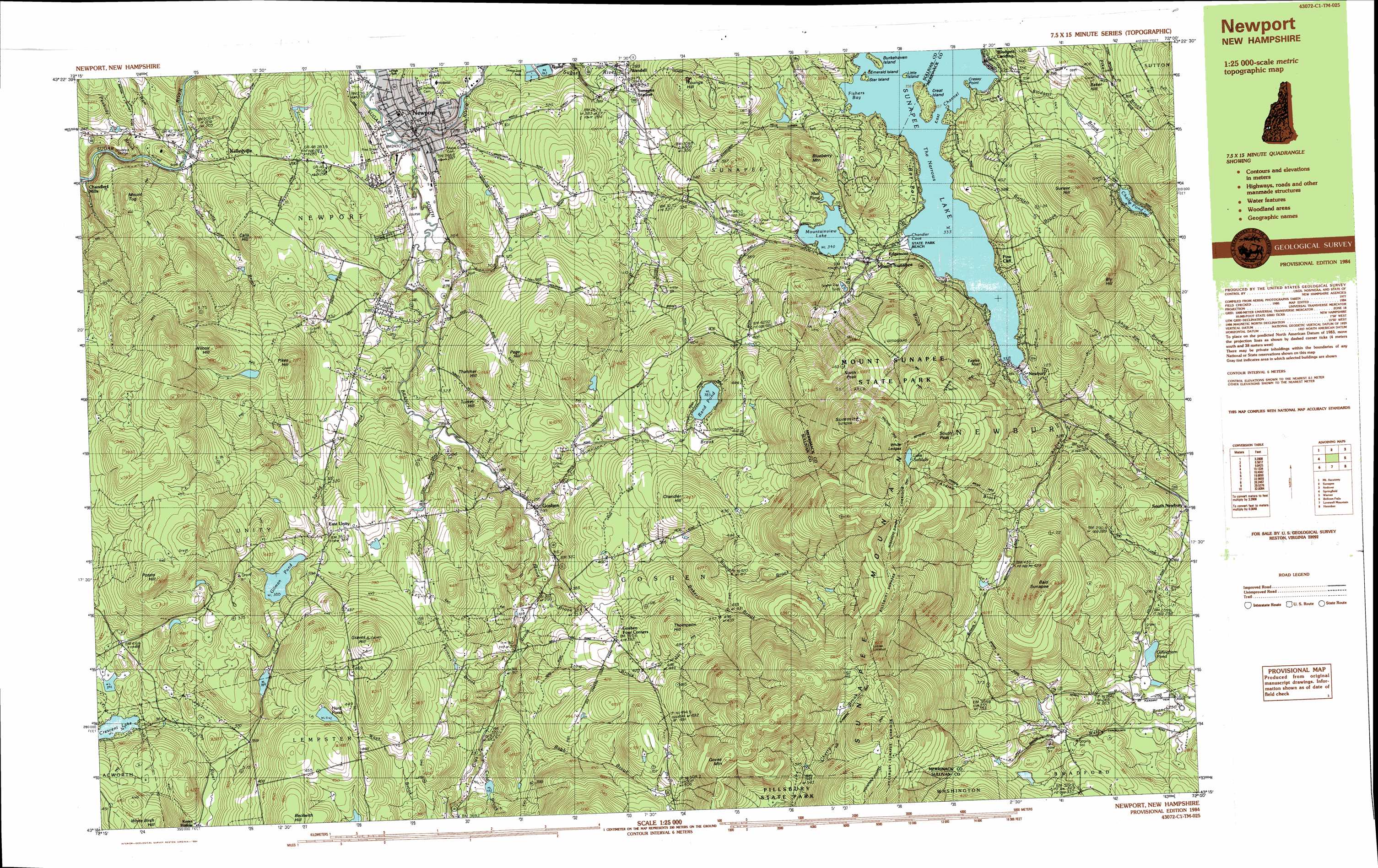
USGS Topo Quad 43072c1 - 1:25,000 scale
| Topo Map Name: | Sunapee Lakes |
| USGS Topo Quad ID: | 43072c1 |
| Print Size: | ca. 39" wide x 24" high |
| Southeast Coordinates: | 43.25° N latitude / 72° W longitude |
| Map Center Coordinates: | 43.3125° N latitude / 72.125° W longitude |
| U.S. State: | NH |
| Filename: | k43072c1.jpg |
| Download Map JPG Image: | Sunapee Lakes topo map 1:25,000 scale |
| Map Type: | Topographic |
| Topo Series: | 7.5´x15´ |
| Map Scale: | 1:25,000 |
| Source of Map Images: | United States Geological Survey (USGS) |
| Alternate Map Versions: |
Newport NH 1984, updated 1984 Download PDF Buy paper map Newport NH 1984, updated 1984 Download PDF Buy paper map |
1:24,000 Topo Quads surrounding Sunapee Lakes
North Hartland |
Enfield Center |
Grafton |
Danbury |
|
Claremont North |
Sunapee Lake North |
New London |
Andover |
|
Claremont South |
Sunapee Lakes |
Bradford |
Warner |
|
Alstead |
Washington |
Hillsboro Upper Village |
Henniker |
|
Gilsum |
Stoddard |
Hillsboro |
Deering |
> Back to 43072a1 at 1:100,000 scale
> Back to 43072a1 at 1:250,000 scale
> Back to U.S. Topo Maps home
Sunapee Lakes topo map: Gazetteer
Sunapee Lakes: Bays
Fishers Bay elevation 333m 1092′Sunapee Lakes: Beaches
State Park Beach elevation 334m 1095′Sunapee Lakes: Bridges
Pier Bridge elevation 205m 672′Sunapee Lakes: Capes
Bay Point elevation 354m 1161′Cressey Point elevation 334m 1095′
Sunapee Lakes: Channels
East Channel elevation 333m 1092′The Narrows elevation 333m 1092′
Sunapee Lakes: Dams
Cold River Dam Number 8 elevation 330m 1082′Gilman Pond Dam elevation 391m 1282′
Professor Dam elevation 259m 849′
Sugar River Dam Number 2 elevation 270m 885′
Sunapee Lakes: Islands
Burkehaven Island elevation 335m 1099′Emerald Island elevation 334m 1095′
Great Island elevation 341m 1118′
Little Island elevation 336m 1102′
Star Island elevation 336m 1102′
Sunapee Lakes: Lakes
Chalk Pond elevation 380m 1246′Gillingham Pond elevation 248m 813′
Hurd Pond elevation 442m 1450′
Lake Solitude elevation 765m 2509′
Mountainview Lake elevation 340m 1115′
Mud Pond elevation 341m 1118′
Rand Pond elevation 383m 1256′
Sunapee Lakes: Parks
Gallop Marsh State Wildlife Management Area elevation 407m 1335′John Hay National Wildlife Refuge elevation 362m 1187′
Mount Sunapee State Park elevation 586m 1922′
Newport Town Common elevation 279m 915′
Sunapee Lakes: Populated Places
Blodgett Landing elevation 340m 1115′Box Corner elevation 292m 958′
Chandlers Mills elevation 196m 643′
East Unity elevation 366m 1200′
Edgemont elevation 364m 1194′
Goshen elevation 297m 974′
Goshen Four Corners elevation 397m 1302′
Kelleyville elevation 205m 672′
Keyes Hollow elevation 333m 1092′
Mount Sunapee elevation 341m 1118′
Newbury elevation 339m 1112′
Newport elevation 250m 820′
Pine Cliff elevation 347m 1138′
Wendell elevation 263m 862′
Sunapee Lakes: Post Offices
Newport Post Office elevation 251m 823′Sunapee Lakes: Reservoirs
Cold Brook Pond elevation 330m 1082′Gilman Pond elevation 391m 1282′
Gordon Woolen Mill Pond elevation 270m 885′
Rollins Pond elevation 259m 849′
Sunapee Lakes: Streams
Babb Brook elevation 315m 1033′Baker Brook elevation 378m 1240′
Blodgett Brook elevation 336m 1102′
Blood Brook elevation 291m 954′
Chandler Brook elevation 333m 1092′
Chandler Brook elevation 334m 1095′
Cold Brook elevation 327m 1072′
Cutts Brook elevation 206m 675′
Giles Brook elevation 299m 980′
Gunnison Brook elevation 294m 964′
Johnson Brook elevation 333m 1092′
Peabody Brook elevation 204m 669′
Purmort Brook elevation 310m 1017′
Ram Brook elevation 204m 669′
South Branch Sugar River elevation 237m 777′
Spring Brook elevation 277m 908′
Trask Brook elevation 280m 918′
Trow Brook elevation 307m 1007′
Sunapee Lakes: Summits
Baker Hill elevation 418m 1371′Bald Sunapee elevation 632m 2073′
Bear Hill elevation 475m 1558′
Blueberry Mountain elevation 460m 1509′
Bly Hill elevation 614m 2014′
Calls Hill elevation 369m 1210′
Chandler Hill elevation 482m 1581′
Eagles Nest elevation 530m 1738′
Goves Mountain elevation 721m 2365′
Graves Hill elevation 524m 1719′
Lucias Lookout elevation 756m 2480′
Mount Tug elevation 360m 1181′
North Peak elevation 692m 2270′
Page Hill elevation 459m 1505′
Pikes Hill elevation 474m 1555′
Potato Hill elevation 570m 1870′
South Peak elevation 794m 2604′
Summit elevation 828m 2716′
Sunapee Mountain elevation 824m 2703′
Sunset Hill elevation 558m 1830′
Thatcher Hill elevation 441m 1446′
Thompson Hill elevation 503m 1650′
White Birch Hill elevation 486m 1594′
Wilcox Hill elevation 510m 1673′
Youngs Hill elevation 416m 1364′
Sunapee Lakes digital topo map on disk
Buy this Sunapee Lakes topo map showing relief, roads, GPS coordinates and other geographical features, as a high-resolution digital map file on DVD:
New York, Vermont, Connecticut & Western Massachusetts
Buy digital topo maps: New York, Vermont, Connecticut & Western Massachusetts