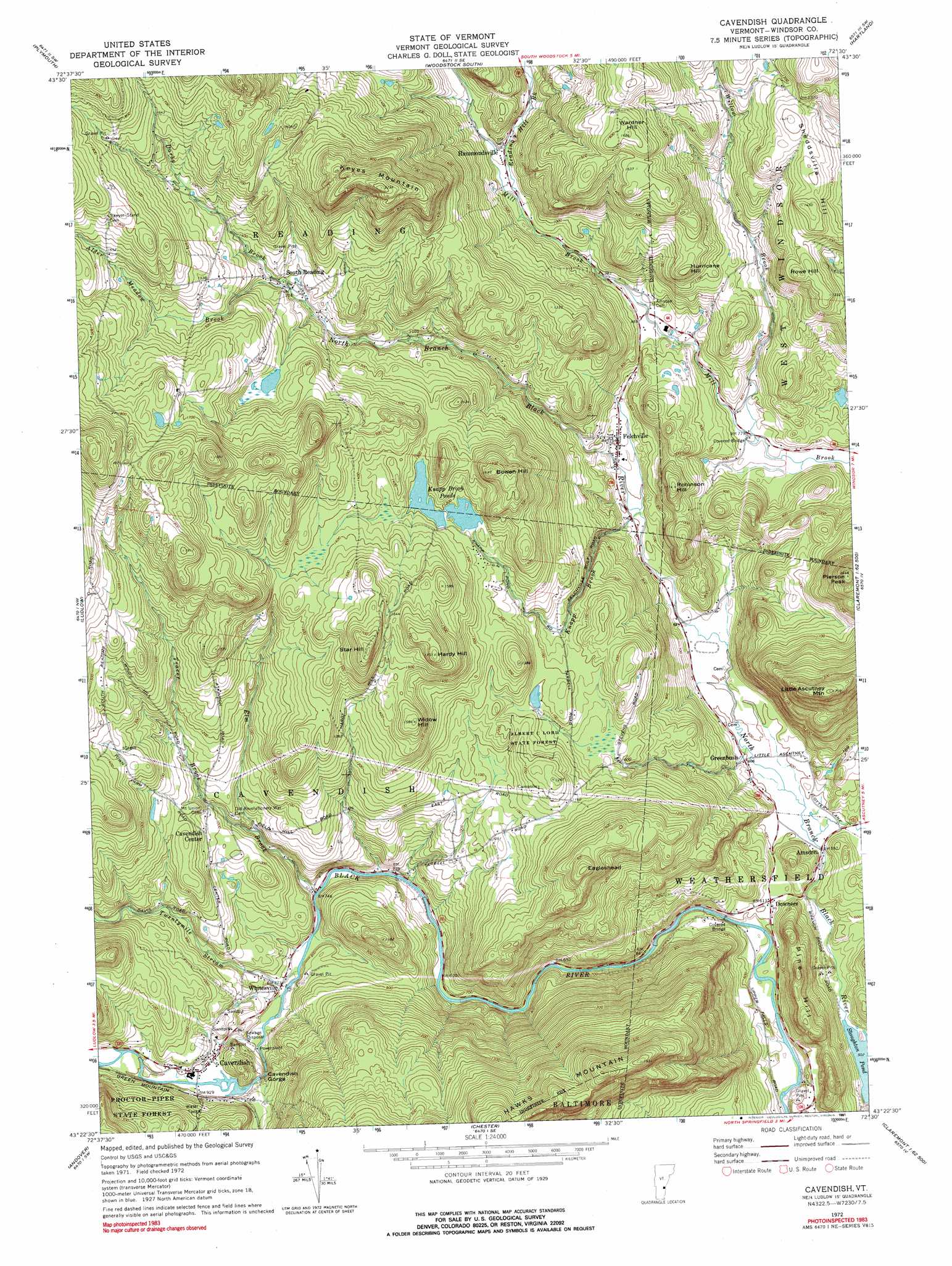
Cavendish Topo Map Vermont
To zoom in, hover over the map of Cavendish
USGS Topo Quad 43072d5 - 1:24,000 scale
| Topo Map Name: | Cavendish |
| USGS Topo Quad ID: | 43072d5 |
| Print Size: | ca. 21 1/4" wide x 27" high |
| Southeast Coordinates: | 43.375° N latitude / 72.5° W longitude |
| Map Center Coordinates: | 43.4375° N latitude / 72.5625° W longitude |
| U.S. State: | VT |
| Filename: | o43072d5.jpg |
| Download Map JPG Image: | Cavendish topo map 1:24,000 scale |
| Map Type: | Topographic |
| Topo Series: | 7.5´ |
| Map Scale: | 1:24,000 |
| Source of Map Images: | United States Geological Survey (USGS) |
| Alternate Map Versions: |
Cavendish VT 1972, updated 1974 Download PDF Buy paper map Cavendish VT 1972, updated 1991 Download PDF Buy paper map Cavendish VT 1972, updated 1991 Download PDF Buy paper map Cavendish VT 2012 Download PDF Buy paper map Cavendish VT 2015 Download PDF Buy paper map |
1:24,000 Topo Quads surrounding Cavendish
Pico Peak |
Delectable Mountain |
Woodstock North |
Quechee |
Hanover |
Killington Peak |
Plymouth |
Woodstock South |
Hartland |
North Hartland |
Mount Holly |
Ludlow |
Cavendish |
Claremont North |
|
Weston |
Andover |
Chester |
Claremont South |
|
Londonderry |
Saxtons River |
Alstead |
> Back to 43072a1 at 1:100,000 scale
> Back to 43072a1 at 1:250,000 scale
> Back to U.S. Topo Maps home
Cavendish topo map: Gazetteer
Cavendish: Bridges
Bests Covered Bridge elevation 241m 790′Upper Falls Covered Bridge elevation 174m 570′
Cavendish: Dams
Cavendish Dam elevation 272m 892′Knapp Brook Site Number 1 Dam elevation 393m 1289′
Knapp Brook Site Number 2 Dam elevation 476m 1561′
Cavendish: Forests
Albert C Lord State Forest elevation 374m 1227′Reading Municipal Forest elevation 446m 1463′
Weathersfield Municipal Forest elevation 257m 843′
Cavendish: Lakes
Knapp Brook Ponds elevation 396m 1299′Cavendish: Parks
Hawks Mountain Wildlife Management Area elevation 376m 1233′Knapp Brook Wildlife Management Area elevation 416m 1364′
Cavendish: Populated Places
Amsden elevation 189m 620′Cavendish elevation 275m 902′
Cavendish Center elevation 315m 1033′
Downers elevation 191m 626′
Felchville elevation 234m 767′
Greenbush elevation 185m 606′
Hammondsville elevation 320m 1049′
South Reading elevation 389m 1276′
Whitesville elevation 237m 777′
Cavendish: Reservoirs
Knapp Brook Pond Number 1 elevation 393m 1289′Knapp Brook Upper Pond elevation 476m 1561′
Cavendish: Streams
Alder Meadow Brook elevation 393m 1289′Darby Brook elevation 392m 1286′
Elm Brook elevation 232m 761′
Knapp Brook elevation 227m 744′
Reading Hill Brook elevation 293m 961′
Tracer Brook elevation 276m 905′
Twentymile Stream elevation 235m 770′
Willow Brook elevation 241m 790′
Cavendish: Summits
Bowen Hill elevation 514m 1686′Eagleshead elevation 494m 1620′
Hardy Hill elevation 530m 1738′
Hurricane Hill elevation 398m 1305′
Keyes Mountain elevation 642m 2106′
Little Ascutney Mountain elevation 525m 1722′
Pierson Peak elevation 493m 1617′
Robinson Hill elevation 358m 1174′
Rowe Hill elevation 420m 1377′
Sheddsville Hill elevation 446m 1463′
Star Hill elevation 536m 1758′
Wardner Hill elevation 495m 1624′
Widow Hill elevation 482m 1581′
Cavendish: Valleys
Cavendish Gorge elevation 248m 813′Cavendish digital topo map on disk
Buy this Cavendish topo map showing relief, roads, GPS coordinates and other geographical features, as a high-resolution digital map file on DVD:
New York, Vermont, Connecticut & Western Massachusetts
Buy digital topo maps: New York, Vermont, Connecticut & Western Massachusetts