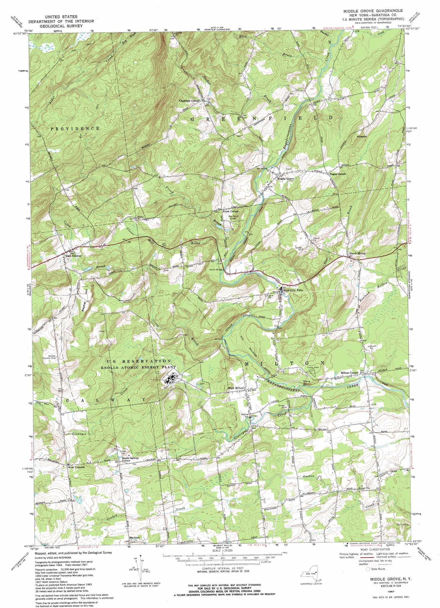
Middle Grove Topo Map New York
To zoom in, hover over the map of Middle Grove
USGS Topo Quad 43073a8 - 1:24,000 scale
| Topo Map Name: | Middle Grove |
| USGS Topo Quad ID: | 43073a8 |
| Print Size: | ca. 21 1/4" wide x 27" high |
| Southeast Coordinates: | 43° N latitude / 73.875° W longitude |
| Map Center Coordinates: | 43.0625° N latitude / 73.9375° W longitude |
| U.S. State: | NY |
| Filename: | o43073a8.jpg |
| Download Map JPG Image: | Middle Grove topo map 1:24,000 scale |
| Map Type: | Topographic |
| Topo Series: | 7.5´ |
| Map Scale: | 1:24,000 |
| Source of Map Images: | United States Geological Survey (USGS) |
| Alternate Map Versions: |
Middle Grove NY 1935 Download PDF Buy paper map Middle Grove NY 1967, updated 1971 Download PDF Buy paper map Middle Grove NY 1967, updated 1985 Download PDF Buy paper map Middle Grove NY 2010 Download PDF Buy paper map Middle Grove NY 2013 Download PDF Buy paper map Middle Grove NY 2016 Download PDF Buy paper map |
1:24,000 Topo Quads surrounding Middle Grove
Ohmer Mountain |
Conklingville |
Lake Luzerne |
Glens Falls |
|
Northville |
Edinburg |
Porter Corners |
Corinth |
Gansevoort |
Broadalbin |
Galway |
Middle Grove |
Saratoga Springs |
Quaker Springs |
Amsterdam |
Pattersonville |
Burnt Hills |
Round Lake |
Mechanicville |
Duanesburg |
Rotterdam Junction |
Schenectady |
Niskayuna |
Troy North |
> Back to 43073a1 at 1:100,000 scale
> Back to 43072a1 at 1:250,000 scale
> Back to U.S. Topo Maps home
Middle Grove topo map: Gazetteer
Middle Grove: Bridges
Hatch Bridge elevation 155m 508′Middle Grove: Populated Places
Birchton elevation 183m 600′Chatfield Corner elevation 246m 807′
East Galway elevation 272m 892′
Frink Corner elevation 194m 636′
Middle Grove elevation 168m 551′
Milton Center elevation 116m 380′
North Milton elevation 153m 501′
Pages Corner elevation 190m 623′
Rock City Falls elevation 138m 452′
South Galway Corner elevation 166m 544′
West Corners elevation 184m 603′
West Milton elevation 134m 439′
Middle Grove: Streams
Blue Brook elevation 170m 557′Clover Mill Creek elevation 155m 508′
Crook Brook elevation 122m 400′
Frink Brook elevation 155m 508′
Gasher Brook elevation 167m 547′
Glowegee Creek elevation 113m 370′
Peacock Brook elevation 169m 554′
Rose Brook elevation 439m 1440′
Star Brook elevation 125m 410′
Middle Grove: Summits
Baptist Hill elevation 263m 862′Hyspot elevation 220m 721′
Middle Grove digital topo map on disk
Buy this Middle Grove topo map showing relief, roads, GPS coordinates and other geographical features, as a high-resolution digital map file on DVD:
New York, Vermont, Connecticut & Western Massachusetts
Buy digital topo maps: New York, Vermont, Connecticut & Western Massachusetts