Salem Topo Map New York
To zoom in, hover over the map of Salem
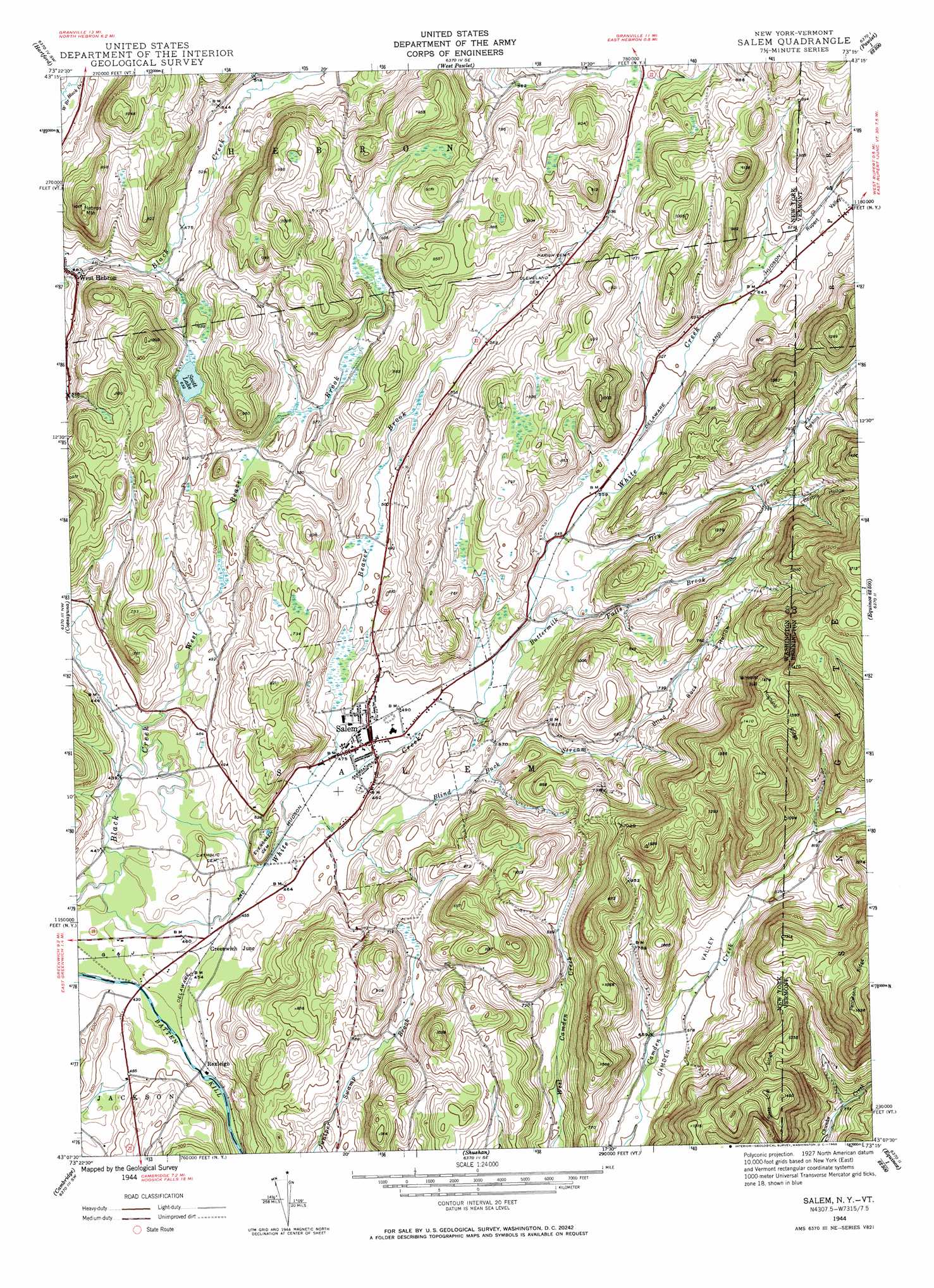
USGS Topo Quad 43073b3 - 1:24,000 scale
| Topo Map Name: | Salem |
| USGS Topo Quad ID: | 43073b3 |
| Print Size: | ca. 21 1/4" wide x 27" high |
| Southeast Coordinates: | 43.125° N latitude / 73.25° W longitude |
| Map Center Coordinates: | 43.1875° N latitude / 73.3125° W longitude |
| U.S. States: | NY, VT |
| Filename: | o43073b3.jpg |
| Download Map JPG Image: | Salem topo map 1:24,000 scale |
| Map Type: | Topographic |
| Topo Series: | 7.5´ |
| Map Scale: | 1:24,000 |
| Source of Map Images: | United States Geological Survey (USGS) |
| Alternate Map Versions: |
Salem NY 1944, updated 1958 Download PDF Buy paper map Salem NY 1944, updated 1965 Download PDF Buy paper map Salem NY 1995, updated 2000 Download PDF Buy paper map Salem NY 2011 Download PDF Buy paper map Salem NY 2013 Download PDF Buy paper map Salem NY 2016 Download PDF Buy paper map |
| FStopo: | US Forest Service topo Salem is available: Download FStopo PDF Download FStopo TIF |
1:24,000 Topo Quads surrounding Salem
Putnam Mountain |
Fort Ann |
Granville |
Wells |
Middletown Springs |
Hudson Falls |
Hartford |
West Pawlet |
Pawlet |
Dorset |
Fort Miller |
Cossayuna |
Salem |
West Rupert |
Manchester |
Schuylerville |
Cambridge |
Shushan |
Arlington |
Sunderland |
Schaghticoke |
Eagle Bridge |
Hoosick Falls |
Bennington |
Woodford |
> Back to 43073a1 at 1:100,000 scale
> Back to 43072a1 at 1:250,000 scale
> Back to U.S. Topo Maps home
Salem topo map: Gazetteer
Salem: Bridges
Rexleigh Bridge elevation 132m 433′Salem: Lakes
Scott Lake elevation 192m 629′Salem: Parks
Salem Historic District elevation 147m 482′Salem: Populated Places
Greenwich Junction elevation 138m 452′Rexleigh elevation 136m 446′
Salem elevation 147m 482′
Salem: Ridges
Hogback Ridge elevation 427m 1400′Panteleoni Ridge elevation 473m 1551′
State Line Ridge elevation 395m 1295′
Salem: Streams
Baldwin Brook elevation 243m 797′Beaver Brook elevation 143m 469′
Blind Buck Stream elevation 137m 449′
Buttermilk Falls Brook elevation 152m 498′
Dry Creek elevation 162m 531′
Terry Brook elevation 243m 797′
West Beaver Brook elevation 133m 436′
White Creek elevation 128m 419′
White Creek elevation 128m 419′
White Creek elevation 128m 419′
White Creek elevation 128m 419′
Salem: Summits
Hebron Mountain elevation 306m 1003′Wheeler Hill elevation 445m 1459′
Salem: Valleys
Beattie Hollow elevation 219m 718′Beattie Hollow elevation 253m 830′
Blind Buck Hollow elevation 181m 593′
Perkins Hollow elevation 175m 574′
Perkins Hollow elevation 229m 751′
Rupert Valley elevation 200m 656′
Salem digital topo map on disk
Buy this Salem topo map showing relief, roads, GPS coordinates and other geographical features, as a high-resolution digital map file on DVD:
New York, Vermont, Connecticut & Western Massachusetts
Buy digital topo maps: New York, Vermont, Connecticut & Western Massachusetts