Middletown Springs Topo Map Vermont
To zoom in, hover over the map of Middletown Springs
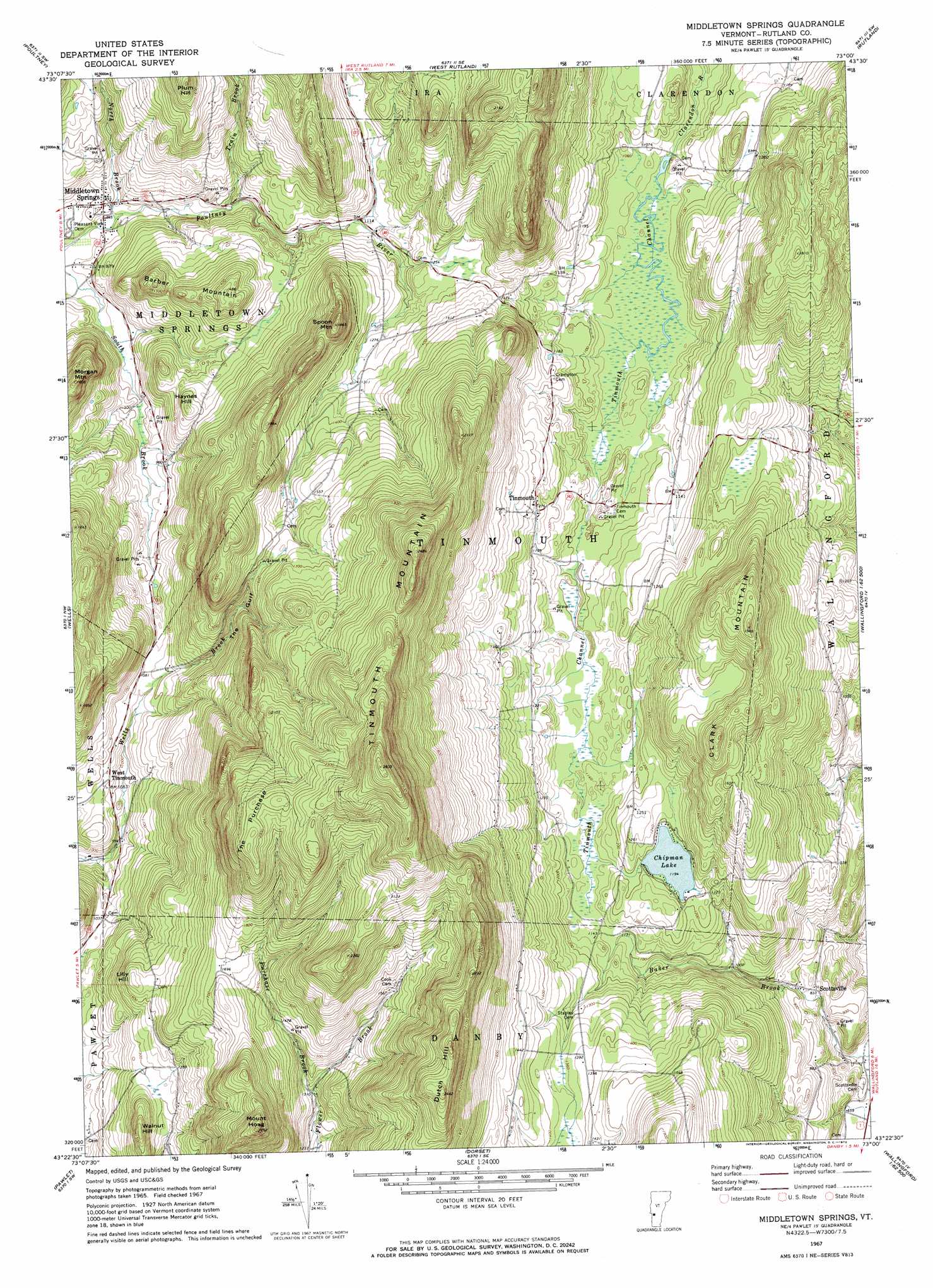
USGS Topo Quad 43073d1 - 1:24,000 scale
| Topo Map Name: | Middletown Springs |
| USGS Topo Quad ID: | 43073d1 |
| Print Size: | ca. 21 1/4" wide x 27" high |
| Southeast Coordinates: | 43.375° N latitude / 73° W longitude |
| Map Center Coordinates: | 43.4375° N latitude / 73.0625° W longitude |
| U.S. State: | VT |
| Filename: | o43073d1.jpg |
| Download Map JPG Image: | Middletown Springs topo map 1:24,000 scale |
| Map Type: | Topographic |
| Topo Series: | 7.5´ |
| Map Scale: | 1:24,000 |
| Source of Map Images: | United States Geological Survey (USGS) |
| Alternate Map Versions: |
Middletown Springs VT 1967, updated 1972 Download PDF Buy paper map Middletown Springs VT 1967, updated 1972 Download PDF Buy paper map Middletown Springs VT 1967, updated 1972 Download PDF Buy paper map Middletown Springs VT 2012 Download PDF Buy paper map Middletown Springs VT 2015 Download PDF Buy paper map |
1:24,000 Topo Quads surrounding Middletown Springs
Benson |
Bomoseen |
Proctor |
Chittenden |
Pico Peak |
Thorn Hill |
Poultney |
West Rutland |
Rutland |
Killington Peak |
Granville |
Wells |
Middletown Springs |
Wallingford |
Mount Holly |
West Pawlet |
Pawlet |
Dorset |
Danby |
Weston |
Salem |
West Rupert |
Manchester |
Peru |
Londonderry |
> Back to 43073a1 at 1:100,000 scale
> Back to 43072a1 at 1:250,000 scale
> Back to U.S. Topo Maps home
Middletown Springs topo map: Gazetteer
Middletown Springs: Canals
Tinmouth Channel elevation 335m 1099′Middletown Springs: Lakes
Chipman Lake elevation 364m 1194′Middletown Springs: Parks
Middletown Springs Historic District elevation 275m 902′Tinmouth Channel Wildlife Management Area elevation 322m 1056′
Tinmouth Historic District elevation 392m 1286′
Middletown Springs: Populated Places
Middletown Springs elevation 274m 898′Scottsville elevation 253m 830′
Tinmouth elevation 382m 1253′
West Tinmouth elevation 319m 1046′
Middletown Springs: Post Offices
Middletown Springs Post Office elevation 282m 925′Middletown Springs: Streams
North Brook elevation 271m 889′Purchase Brook elevation 400m 1312′
Train Brook elevation 306m 1003′
Middletown Springs: Summits
Barber Mountain elevation 452m 1482′Clark Mountain elevation 596m 1955′
Dutch Hill elevation 735m 2411′
Fayette Mountain elevation 693m 2273′
Haynes Hill elevation 387m 1269′
Lily Hill elevation 454m 1489′
Morgan Mountain elevation 478m 1568′
Mount Hoag elevation 677m 2221′
Plum Hill elevation 536m 1758′
Spoon Mountain elevation 545m 1788′
The Purchase elevation 725m 2378′
Tinmouth Mountain elevation 859m 2818′
Walnut Hill elevation 464m 1522′
Middletown Springs: Valleys
The Gulf elevation 343m 1125′Middletown Springs digital topo map on disk
Buy this Middletown Springs topo map showing relief, roads, GPS coordinates and other geographical features, as a high-resolution digital map file on DVD:
New York, Vermont, Connecticut & Western Massachusetts
Buy digital topo maps: New York, Vermont, Connecticut & Western Massachusetts