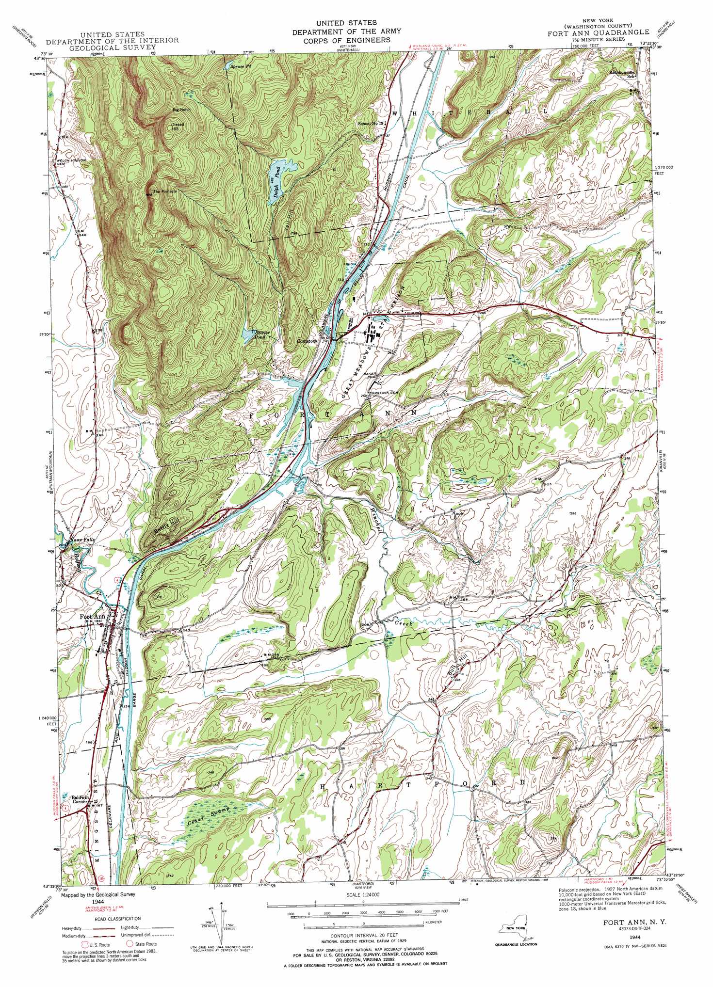
Fort Ann Topo Map New York
To zoom in, hover over the map of Fort Ann
USGS Topo Quad 43073d4 - 1:24,000 scale
| Topo Map Name: | Fort Ann |
| USGS Topo Quad ID: | 43073d4 |
| Print Size: | ca. 21 1/4" wide x 27" high |
| Southeast Coordinates: | 43.375° N latitude / 73.375° W longitude |
| Map Center Coordinates: | 43.4375° N latitude / 73.4375° W longitude |
| U.S. State: | NY |
| Filename: | o43073d4.jpg |
| Download Map JPG Image: | Fort Ann topo map 1:24,000 scale |
| Map Type: | Topographic |
| Topo Series: | 7.5´ |
| Map Scale: | 1:24,000 |
| Source of Map Images: | United States Geological Survey (USGS) |
| Alternate Map Versions: |
Fort Ann NY 1944, updated 1958 Download PDF Buy paper map Fort Ann NY 1944, updated 1968 Download PDF Buy paper map Fort Ann NY 1944, updated 1989 Download PDF Buy paper map Fort Ann NY 2010 Download PDF Buy paper map Fort Ann NY 2013 Download PDF Buy paper map Fort Ann NY 2016 Download PDF Buy paper map |
1:24,000 Topo Quads surrounding Fort Ann
Brant Lake |
Silver Bay |
Putnam |
Benson |
Bomoseen |
Bolton Landing |
Shelving Rock |
Whitehall |
Thorn Hill |
Poultney |
Lake George |
Putnam Mountain |
Fort Ann |
Granville |
Wells |
Glens Falls |
Hudson Falls |
Hartford |
West Pawlet |
Pawlet |
Gansevoort |
Fort Miller |
Cossayuna |
Salem |
West Rupert |
> Back to 43073a1 at 1:100,000 scale
> Back to 43072a1 at 1:250,000 scale
> Back to U.S. Topo Maps home
Fort Ann topo map: Gazetteer
Fort Ann: Canals
Champlain Canal elevation 38m 124′Fort Ann: Falls
Kane Falls elevation 52m 170′Fort Ann: Gaps
Big Notch elevation 410m 1345′Fort Ann: Lakes
Beaver Pond elevation 107m 351′Dolph Pond elevation 147m 482′
Spruce Pond elevation 338m 1108′
Fort Ann: Mines
Deweys Bridge Quarry elevation 41m 134′Fort Ann Quarry elevation 59m 193′
Hartford Quarry elevation 101m 331′
Fort Ann: Populated Places
Baldwin Corner elevation 49m 160′Comstock elevation 39m 127′
Fort Ann elevation 48m 157′
Fort Ann: Streams
Halfway Creek elevation 38m 124′Winchell Creek elevation 38m 124′
Fort Ann: Summits
Battle Hill elevation 134m 439′Bull Hill elevation 99m 324′
Orebed Hill elevation 490m 1607′
The Pinnacle elevation 490m 1607′
Vail Hill elevation 222m 728′
Fort Ann: Swamps
Cedar Swamp elevation 63m 206′Fort Ann digital topo map on disk
Buy this Fort Ann topo map showing relief, roads, GPS coordinates and other geographical features, as a high-resolution digital map file on DVD:
New York, Vermont, Connecticut & Western Massachusetts
Buy digital topo maps: New York, Vermont, Connecticut & Western Massachusetts