Lake George Topo Map New York
To zoom in, hover over the map of Lake George
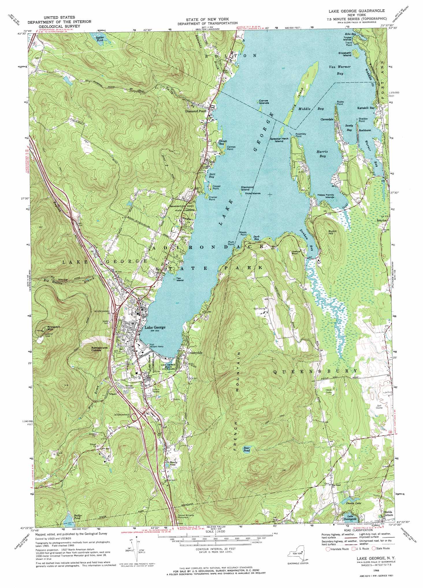
USGS Topo Quad 43073d6 - 1:24,000 scale
| Topo Map Name: | Lake George |
| USGS Topo Quad ID: | 43073d6 |
| Print Size: | ca. 21 1/4" wide x 27" high |
| Southeast Coordinates: | 43.375° N latitude / 73.625° W longitude |
| Map Center Coordinates: | 43.4375° N latitude / 73.6875° W longitude |
| U.S. State: | NY |
| Filename: | o43073d6.jpg |
| Download Map JPG Image: | Lake George topo map 1:24,000 scale |
| Map Type: | Topographic |
| Topo Series: | 7.5´ |
| Map Scale: | 1:24,000 |
| Source of Map Images: | United States Geological Survey (USGS) |
| Alternate Map Versions: |
Lake George NY 1966, updated 1969 Download PDF Buy paper map Lake George NY 1966, updated 1970 Download PDF Buy paper map Lake George NY 1966, updated 1970 Download PDF Buy paper map Lake George NY 2010 Download PDF Buy paper map Lake George NY 2013 Download PDF Buy paper map Lake George NY 2016 Download PDF Buy paper map |
1:24,000 Topo Quads surrounding Lake George
North Creek |
Chestertown |
Brant Lake |
Silver Bay |
Putnam |
Johnsburg |
The Glen |
Bolton Landing |
Shelving Rock |
Whitehall |
Stony Creek |
Warrensburg |
Lake George |
Putnam Mountain |
Fort Ann |
Conklingville |
Lake Luzerne |
Glens Falls |
Hudson Falls |
Hartford |
Porter Corners |
Corinth |
Gansevoort |
Fort Miller |
Cossayuna |
> Back to 43073a1 at 1:100,000 scale
> Back to 43072a1 at 1:250,000 scale
> Back to U.S. Topo Maps home
Lake George topo map: Gazetteer
Lake George: Bays
Dark Bay elevation 97m 318′Dunham Bay elevation 97m 318′
Echo Bay elevation 97m 318′
Harris Bay elevation 97m 318′
Kattskill Bay elevation 110m 360′
Middle Bay elevation 97m 318′
Orcutt Bay elevation 97m 318′
Sandy Bay elevation 97m 318′
Still Bay elevation 97m 318′
Van Warmer Bay elevation 97m 318′
Warner Bay elevation 97m 318′
Lake George: Capes
Assembly Point elevation 98m 321′Cannon Point elevation 98m 321′
Cooper Point elevation 103m 337′
Cramer Point elevation 98m 321′
Plum Point elevation 99m 324′
Ripley Point elevation 98m 321′
Sheldon Point elevation 97m 318′
Travis Point elevation 100m 328′
Woods Point elevation 103m 337′
Lake George: Crossings
Interchange 21 elevation 159m 521′Interchange 22 elevation 154m 505′
Lake George: Islands
Canoe Islands elevation 99m 324′Diamond Island elevation 98m 321′
Dicks Islands elevation 98m 321′
Elizabeth Island elevation 111m 364′
Happy Family Islands elevation 97m 318′
Long Island elevation 99m 324′
Speaker Heck Island elevation 99m 324′
Tea Island elevation 98m 321′
Triplet Islands elevation 97m 318′
Lake George: Lakes
Bear Pond elevation 349m 1145′Beaver Pond elevation 275m 902′
Bloody Pond elevation 170m 557′
Dream Lake elevation 99m 324′
Lake Sunnyside elevation 109m 357′
Lake George: Parks
Colonel Williams Monument elevation 181m 593′Lake George Battlefield Park elevation 103m 337′
Lake George Beach State Park elevation 99m 324′
Lake George: Populated Places
Brayton elevation 113m 370′Cleverdale elevation 106m 347′
Crosbyside elevation 119m 390′
Diamond Point elevation 101m 331′
Lake George elevation 105m 344′
Oneida Corners elevation 115m 377′
Rockhurst elevation 106m 347′
Lake George: Streams
Big Hollow Branch elevation 157m 515′Edmunds Brook elevation 97m 318′
English Brook elevation 98m 321′
Smith Brook elevation 98m 321′
West Brook elevation 98m 321′
Lake George: Summits
Burnt Hill elevation 172m 564′French Mountain elevation 439m 1440′
Joshua Rock elevation 160m 524′
Prospect Mountain elevation 615m 2017′
Rattlesnake Cobble elevation 369m 1210′
Lake George digital topo map on disk
Buy this Lake George topo map showing relief, roads, GPS coordinates and other geographical features, as a high-resolution digital map file on DVD:
New York, Vermont, Connecticut & Western Massachusetts
Buy digital topo maps: New York, Vermont, Connecticut & Western Massachusetts