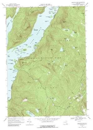
Shelving Rock Topo Map New York
To zoom in, hover over the map of Shelving Rock
USGS Topo Quad 43073e5 - 1:24,000 scale
| Topo Map Name: | Shelving Rock |
| USGS Topo Quad ID: | 43073e5 |
| Print Size: | ca. 21 1/4" wide x 27" high |
| Southeast Coordinates: | 43.5° N latitude / 73.5° W longitude |
| Map Center Coordinates: | 43.5625° N latitude / 73.5625° W longitude |
| U.S. State: | NY |
| Filename: | o43073e5.jpg |
| Download Map JPG Image: | Shelving Rock topo map 1:24,000 scale |
| Map Type: | Topographic |
| Topo Series: | 7.5´ |
| Map Scale: | 1:24,000 |
| Source of Map Images: | United States Geological Survey (USGS) |
| Alternate Map Versions: |
Shelving Rock NY 1966, updated 1970 Download PDF Buy paper map Shelving Rock NY 1966, updated 1977 Download PDF Buy paper map Shelving Rock NY 1966, updated 1988 Download PDF Buy paper map Shelving Rock NY 2010 Download PDF Buy paper map Shelving Rock NY 2013 Download PDF Buy paper map Shelving Rock NY 2016 Download PDF Buy paper map |
1:24,000 Topo Quads surrounding Shelving Rock
> Back to 43073e1 at 1:100,000 scale
> Back to 43072a1 at 1:250,000 scale
> Back to U.S. Topo Maps home
Shelving Rock topo map: Gazetteer
Shelving Rock: Airports
Northwest Waterbird Seaplane Base elevation 97m 318′Shelving Rock: Bays
Northwest Bay elevation 97m 318′Red Rock Bay elevation 97m 318′
Shelving Rock Bay elevation 97m 318′
Shelving Rock: Capes
Bear Point elevation 102m 334′Black Mountain Point elevation 97m 318′
French Point elevation 98m 321′
Pearl Point elevation 97m 318′
Watch Point elevation 98m 321′
Shelving Rock: Channels
The Narrows elevation 97m 318′Shelving Rock: Islands
Bass Island elevation 98m 321′Big Burnt Island elevation 106m 347′
Coopers Island elevation 99m 324′
Duran Island elevation 99m 324′
East and West Dollar Islands elevation 99m 324′
Floating Battery Island elevation 99m 324′
Fork Island elevation 99m 324′
Fourteenmile Island elevation 99m 324′
Glen Island elevation 97m 318′
Halfway Island elevation 97m 318′
Hatchet Island elevation 99m 324′
Hazel Island elevation 98m 321′
Hen and Chickens Islands elevation 99m 324′
Horicon Island elevation 99m 324′
Huckleberry Island elevation 99m 324′
Juanita Island elevation 99m 324′
Little Burgess Island elevation 99m 324′
Little Harbor Island elevation 99m 324′
Log Bay Island elevation 101m 331′
Mohican Island elevation 99m 324′
Mother Bunch Islands elevation 99m 324′
Oahu Island elevation 99m 324′
Perch Island elevation 99m 324′
Phantom Island elevation 98m 321′
Phelps Island elevation 99m 324′
Phenita Island elevation 99m 324′
Picnic Island elevation 98m 321′
Pine Island elevation 98m 321′
Ranger Island elevation 99m 324′
Refuge Island elevation 99m 324′
Sagamore Island elevation 99m 324′
Three Sirens Island elevation 99m 324′
Turtle Island elevation 101m 331′
Uncas Island elevation 99m 324′
Watch Island elevation 98m 321′
Shelving Rock: Lakes
Black Mountain Ponds elevation 523m 1715′Bumps Pond elevation 617m 2024′
Crossett Pond elevation 445m 1459′
Fishbrook Pond elevation 559m 1833′
Greenland Pond elevation 489m 1604′
Lake George elevation 97m 318′
Lapland Pond elevation 526m 1725′
Millman Pond elevation 568m 1863′
Spectacle Ponds elevation 501m 1643′
Thurber Pond elevation 421m 1381′
Shelving Rock: Populated Places
Hogtown elevation 366m 1200′South Bay elevation 35m 114′
Shelving Rock: Streams
Mount Hope Brook elevation 29m 95′Northwest Bay Brook elevation 97m 318′
Shelving Rock Brook elevation 97m 318′
Spectacle Brook elevation 29m 95′
Shelving Rock: Summits
Black Mountain elevation 805m 2641′Buck Mountain elevation 711m 2332′
Elephant Mountain elevation 580m 1902′
Erebus Mountain elevation 765m 2509′
Fifth Peak elevation 548m 1797′
First Peak elevation 479m 1571′
French Point Mountain elevation 529m 1735′
Little Buck Mountain elevation 487m 1597′
Shelving Rock Mountain elevation 343m 1125′
Sleeping Beauty elevation 659m 2162′
Shelving Rock digital topo map on disk
Buy this Shelving Rock topo map showing relief, roads, GPS coordinates and other geographical features, as a high-resolution digital map file on DVD:
New York, Vermont, Connecticut & Western Massachusetts
Buy digital topo maps: New York, Vermont, Connecticut & Western Massachusetts


