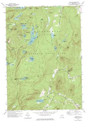
Graphite Topo Map New York
To zoom in, hover over the map of Graphite
USGS Topo Quad 43073g5 - 1:24,000 scale
| Topo Map Name: | Graphite |
| USGS Topo Quad ID: | 43073g5 |
| Print Size: | ca. 21 1/4" wide x 27" high |
| Southeast Coordinates: | 43.75° N latitude / 73.5° W longitude |
| Map Center Coordinates: | 43.8125° N latitude / 73.5625° W longitude |
| U.S. State: | NY |
| Filename: | o43073g5.jpg |
| Download Map JPG Image: | Graphite topo map 1:24,000 scale |
| Map Type: | Topographic |
| Topo Series: | 7.5´ |
| Map Scale: | 1:24,000 |
| Source of Map Images: | United States Geological Survey (USGS) |
| Alternate Map Versions: |
Graphite NY 1973, updated 1975 Download PDF Buy paper map Graphite NY 1973, updated 1975 Download PDF Buy paper map Graphite NY 2010 Download PDF Buy paper map Graphite NY 2013 Download PDF Buy paper map Graphite NY 2016 Download PDF Buy paper map |
1:24,000 Topo Quads surrounding Graphite
> Back to 43073e1 at 1:100,000 scale
> Back to 43072a1 at 1:250,000 scale
> Back to U.S. Topo Maps home
Graphite topo map: Gazetteer
Graphite: Benches
Bald Ledge elevation 580m 1902′Graphite: Lakes
Bear Pond elevation 424m 1391′Berrymill Pond elevation 512m 1679′
Clear Pond elevation 436m 1430′
Devils Washdish elevation 467m 1532′
Gooseneck Pond elevation 377m 1236′
Grizzle Ocean elevation 449m 1473′
Haymeadow Pond elevation 504m 1653′
Heart Pond elevation 419m 1374′
Honey Pond elevation 369m 1210′
Lilypad Pond elevation 406m 1332′
Little Rock Pond elevation 424m 1391′
Lost Pond elevation 479m 1571′
Mud Pond elevation 425m 1394′
North Pond elevation 399m 1309′
Otter Pond elevation 388m 1272′
Putnam Pond elevation 399m 1309′
Rock Pond elevation 421m 1381′
Springhill Ponds elevation 554m 1817′
Wintergreen Lake elevation 338m 1108′
Wolf Pond elevation 369m 1210′
Graphite: Populated Places
Graphite elevation 469m 1538′Graphite: Ridges
Burnt Ridge elevation 568m 1863′Sharps Ridge elevation 471m 1545′
Graphite: Streams
Haymeadow Brook elevation 254m 833′Graphite: Summits
Abes Hill elevation 560m 1837′Barton Mountain elevation 670m 2198′
Bear Pond Mountain elevation 564m 1850′
Big Clear Pond Mountain elevation 657m 2155′
Blanchard Mountain elevation 573m 1879′
Ellis Mountain elevation 629m 2063′
Fernette Mountain elevation 517m 1696′
Grizzle Ocean Mountain elevation 564m 1850′
Little Clear Pond Mountain elevation 540m 1771′
Nances Hill elevation 407m 1335′
Old Fort Mountain elevation 623m 2043′
Peaked Hill elevation 593m 1945′
Pine Hill elevation 637m 2089′
Potter Mountain elevation 568m 1863′
Rock Pond Mountain elevation 508m 1666′
Thomas Mountain elevation 470m 1541′
Thunderbolt Mountain elevation 569m 1866′
Treadway Mountain elevation 684m 2244′
Trumbull Mountain elevation 581m 1906′
Wells Hill elevation 421m 1381′
Graphite: Swamps
Cranberry Marsh elevation 418m 1371′Peshette Swamp elevation 443m 1453′
Graphite: Trails
Bear Pond Trail elevation 450m 1476′Berrymile Pond Trail elevation 482m 1581′
Clear Pond Trail elevation 406m 1332′
Lost Pond Trail elevation 462m 1515′
Rock Pond Trail elevation 447m 1466′
Short Swing Trail elevation 387m 1269′
Treadway Mountain Trail elevation 472m 1548′
Graphite digital topo map on disk
Buy this Graphite topo map showing relief, roads, GPS coordinates and other geographical features, as a high-resolution digital map file on DVD:
New York, Vermont, Connecticut & Western Massachusetts
Buy digital topo maps: New York, Vermont, Connecticut & Western Massachusetts


