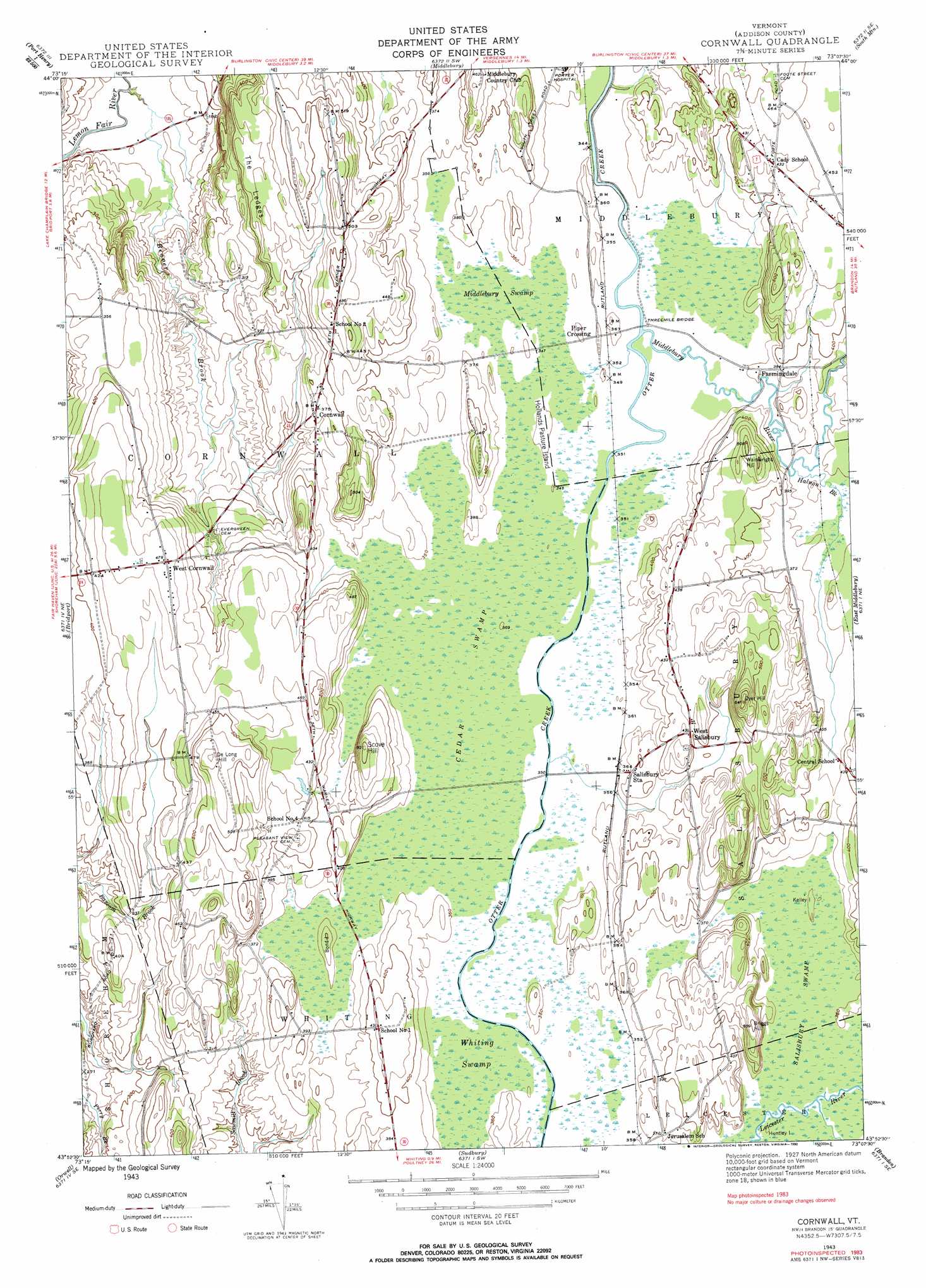
Cornwall Topo Map Vermont
To zoom in, hover over the map of Cornwall
USGS Topo Quad 43073h2 - 1:24,000 scale
| Topo Map Name: | Cornwall |
| USGS Topo Quad ID: | 43073h2 |
| Print Size: | ca. 21 1/4" wide x 27" high |
| Southeast Coordinates: | 43.875° N latitude / 73.125° W longitude |
| Map Center Coordinates: | 43.9375° N latitude / 73.1875° W longitude |
| U.S. State: | VT |
| Filename: | o43073h2.jpg |
| Download Map JPG Image: | Cornwall topo map 1:24,000 scale |
| Map Type: | Topographic |
| Topo Series: | 7.5´ |
| Map Scale: | 1:24,000 |
| Source of Map Images: | United States Geological Survey (USGS) |
| Alternate Map Versions: |
Cornwall VT 1943, updated 1958 Download PDF Buy paper map Cornwall VT 1943, updated 1972 Download PDF Buy paper map Cornwall VT 1943, updated 1983 Download PDF Buy paper map Cornwall VT 1943, updated 1990 Download PDF Buy paper map Cornwall VT 1943, updated 1990 Download PDF Buy paper map Cornwall VT 1983, updated 1990 Download PDF Buy paper map Cornwall VT 2012 Download PDF Buy paper map Cornwall VT 2015 Download PDF Buy paper map |
1:24,000 Topo Quads surrounding Cornwall
Vergennes West |
Vergennes East |
Bristol |
Mount Ellen |
|
Snake Mountain |
Middlebury |
South Mountain |
Lincoln |
|
Crown Point |
Bridport |
Cornwall |
East Middlebury |
Bread Loaf |
Ticonderoga |
Orwell |
Sudbury |
Brandon |
Mount Carmel |
Putnam |
Benson |
Bomoseen |
Proctor |
Chittenden |
> Back to 43073e1 at 1:100,000 scale
> Back to 43072a1 at 1:250,000 scale
> Back to U.S. Topo Maps home
Cornwall topo map: Gazetteer
Cornwall: Bridges
Station Covered Bridge elevation 105m 344′Threemile Bridge elevation 106m 347′
Cornwall: Cliffs
The Ledge elevation 91m 298′Cornwall: Islands
Bond Island elevation 120m 393′Hollands Pasture Island elevation 110m 360′
Huntley Island elevation 110m 360′
Cornwall: Parks
Cornwall Swamp Wildlife Management Area elevation 106m 347′Cornwall: Populated Places
Cornwall elevation 109m 357′Farmingdale elevation 117m 383′
Piper Crossing elevation 110m 360′
Salisbury Station elevation 115m 377′
West Cornwall elevation 142m 465′
West Salisbury elevation 128m 419′
Cornwall: Streams
Beaver Brook elevation 43m 141′Halnon Brook elevation 108m 354′
Middlebury River elevation 105m 344′
Seymour Brook elevation 106m 347′
Cornwall: Summits
De Long Hill elevation 177m 580′Dyer Hill elevation 184m 603′
Scove Hill elevation 154m 505′
Wainwright Hill elevation 152m 498′
Cornwall: Swamps
Cedar Swamp elevation 105m 344′Middlebury Swamp elevation 107m 351′
Salisbury Swamp elevation 111m 364′
Whiting Swamp elevation 106m 347′
Cornwall digital topo map on disk
Buy this Cornwall topo map showing relief, roads, GPS coordinates and other geographical features, as a high-resolution digital map file on DVD:
New York, Vermont, Connecticut & Western Massachusetts
Buy digital topo maps: New York, Vermont, Connecticut & Western Massachusetts