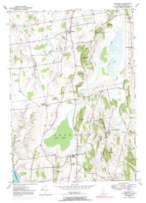
Bridport Topo Map Vermont
To zoom in, hover over the map of Bridport
USGS Topo Quad 43073h3 - 1:24,000 scale
| Topo Map Name: | Bridport |
| USGS Topo Quad ID: | 43073h3 |
| Print Size: | ca. 21 1/4" wide x 27" high |
| Southeast Coordinates: | 43.875° N latitude / 73.25° W longitude |
| Map Center Coordinates: | 43.9375° N latitude / 73.3125° W longitude |
| U.S. States: | VT, NY |
| Filename: | o43073h3.jpg |
| Download Map JPG Image: | Bridport topo map 1:24,000 scale |
| Map Type: | Topographic |
| Topo Series: | 7.5´ |
| Map Scale: | 1:24,000 |
| Source of Map Images: | United States Geological Survey (USGS) |
| Alternate Map Versions: |
Bridport VT 1949, updated 1965 Download PDF Buy paper map Bridport VT 1949, updated 1971 Download PDF Buy paper map Bridport VT 1949, updated 1973 Download PDF Buy paper map Bridport VT 1949, updated 1991 Download PDF Buy paper map Bridport VT 1950 Download PDF Buy paper map Bridport VT 1950 Download PDF Buy paper map Bridport VT 2012 Download PDF Buy paper map Bridport VT 2015 Download PDF Buy paper map |
1:24,000 Topo Quads surrounding Bridport
> Back to 43073e1 at 1:100,000 scale
> Back to 43072a1 at 1:250,000 scale
> Back to U.S. Topo Maps home
Bridport topo map: Gazetteer
Bridport: Airports
Torrey Airport elevation 79m 259′Bridport: Bridges
Fair Bridge elevation 60m 196′Bridport: Capes
Watch Point elevation 31m 101′Bridport: Dams
Richville Dam elevation 76m 249′Bridport: Pillars
The Pinnacle elevation 197m 646′Bridport: Populated Places
Birdport elevation 92m 301′Cream Hill elevation 100m 328′
Shoreham elevation 102m 334′
Bridport: Post Offices
Shoreham Post Office elevation 103m 337′Bridport: Reservoirs
Richville Pond elevation 76m 249′Bridport: Streams
Bascom Brook elevation 48m 157′Perry Brook elevation 48m 157′
Potash Brook elevation 49m 160′
Bridport: Summits
Cloyes Hill elevation 96m 314′Delano Hill elevation 144m 472′
Hamilton Hill elevation 160m 524′
Hemingway Hill elevation 179m 587′
Mutton Hill elevation 171m 561′
Rice Hill elevation 124m 406′
Saint George Hill elevation 108m 354′
Sisson Hill elevation 160m 524′
Bridport: Swamps
Cedar Swamp elevation 74m 242′Bridport digital topo map on disk
Buy this Bridport topo map showing relief, roads, GPS coordinates and other geographical features, as a high-resolution digital map file on DVD:
New York, Vermont, Connecticut & Western Massachusetts
Buy digital topo maps: New York, Vermont, Connecticut & Western Massachusetts


