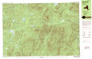
Blue Ridge Topo Map New York
To zoom in, hover over the map of Blue Ridge
USGS Topo Quad 43073h7 - 1:25,000 scale
| Topo Map Name: | Blue Ridge |
| USGS Topo Quad ID: | 43073h7 |
| Print Size: | ca. 39" wide x 24" high |
| Southeast Coordinates: | 43.875° N latitude / 73.75° W longitude |
| Map Center Coordinates: | 43.9375° N latitude / 73.875° W longitude |
| U.S. State: | NY |
| Filename: | k43073h7.jpg |
| Download Map JPG Image: | Blue Ridge topo map 1:25,000 scale |
| Map Type: | Topographic |
| Topo Series: | 7.5´x15´ |
| Map Scale: | 1:25,000 |
| Source of Map Images: | United States Geological Survey (USGS) |
| Alternate Map Versions: |
Blue Ridge NY 1989, updated 1989 Download PDF Buy paper map |
1:24,000 Topo Quads surrounding Blue Ridge
> Back to 43073e1 at 1:100,000 scale
> Back to 43072a1 at 1:250,000 scale
> Back to U.S. Topo Maps home
Blue Ridge topo map: Gazetteer
Blue Ridge: Dams
Brace Dam elevation 546m 1791′Lester Dam elevation 530m 1738′
Blue Ridge: Gaps
Hoffman Notch elevation 532m 1745′Hornet Notch elevation 595m 1952′
Blue Ridge: Lakes
Big Marsh Pond elevation 442m 1450′Black Pond elevation 603m 1978′
Cheney Pond elevation 519m 1702′
Clear Pond elevation 582m 1909′
Fly Pond elevation 603m 1978′
Little Marsh Pond elevation 490m 1607′
Marion Pond elevation 700m 2296′
Mud Pond elevation 491m 1610′
Sand Pond elevation 558m 1830′
Wolf Pond elevation 557m 1827′
Blue Ridge: Populated Places
Blue Ridge elevation 345m 1131′Boreas River elevation 557m 1827′
Blue Ridge: Reservoirs
Lester Flow elevation 530m 1738′Blue Ridge: Ridges
Blue Ridge Range elevation 997m 3270′Texas Ridge elevation 868m 2847′
Washburn Ridge elevation 723m 2372′
Blue Ridge: Streams
Aber Brook elevation 361m 1184′Andrew Brook elevation 557m 1827′
Bailey Pond Inlet elevation 505m 1656′
Brant Brook elevation 522m 1712′
Durgin Brook elevation 528m 1732′
Hoffman Notch Brook elevation 364m 1194′
Niagara Brook elevation 342m 1122′
Sand Pond Brook elevation 365m 1197′
The Gulf Brook elevation 483m 1584′
Walter Coon Brook elevation 562m 1843′
Wolf Pond Brook elevation 532m 1745′
Blue Ridge: Summits
Bailey Hill elevation 931m 3054′Blue Ridge Mountain elevation 1052m 3451′
Clear Pond Mountain elevation 772m 2532′
Dirgylot Hill elevation 411m 1348′
Hewitt Pond Mountain elevation 741m 2431′
Hoffman Mountain elevation 1128m 3700′
Hornet Cobbles elevation 727m 2385′
Jones Hill elevation 567m 1860′
LeClair Hill elevation 558m 1830′
Marsh Pond Mountain elevation 709m 2326′
Nippletop Mountain elevation 900m 2952′
Peaked Hills elevation 593m 1945′
Ragged Mountain elevation 816m 2677′
Sand Pond Mountain elevation 893m 2929′
Saywood Hill elevation 612m 2007′
Smith Hill elevation 435m 1427′
Spruce Mountain elevation 691m 2267′
Squaw Mountain elevation 528m 1732′
Three Brothers Mountain elevation 685m 2247′
Wolf Pond Mountain elevation 1044m 3425′
Wyman Hill elevation 671m 2201′
Blue Ridge: Swamps
Big Marsh elevation 528m 1732′Blue Ridge digital topo map on disk
Buy this Blue Ridge topo map showing relief, roads, GPS coordinates and other geographical features, as a high-resolution digital map file on DVD:
New York, Vermont, Connecticut & Western Massachusetts
Buy digital topo maps: New York, Vermont, Connecticut & Western Massachusetts


