Lassellsville Topo Map New York
To zoom in, hover over the map of Lassellsville
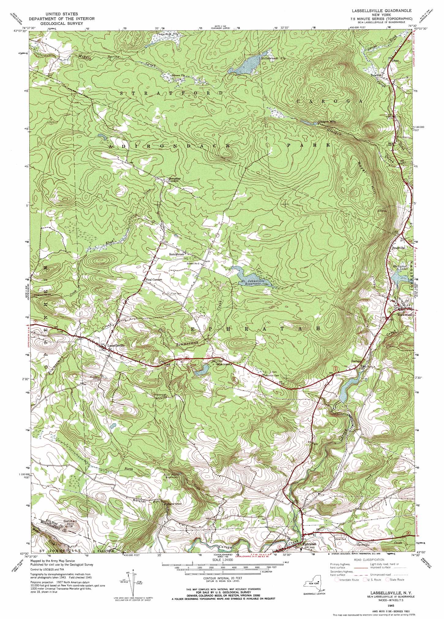
USGS Topo Quad 43074a5 - 1:24,000 scale
| Topo Map Name: | Lassellsville |
| USGS Topo Quad ID: | 43074a5 |
| Print Size: | ca. 21 1/4" wide x 27" high |
| Southeast Coordinates: | 43° N latitude / 74.5° W longitude |
| Map Center Coordinates: | 43.0625° N latitude / 74.5625° W longitude |
| U.S. State: | NY |
| Filename: | o43074a5.jpg |
| Download Map JPG Image: | Lassellsville topo map 1:24,000 scale |
| Map Type: | Topographic |
| Topo Series: | 7.5´ |
| Map Scale: | 1:24,000 |
| Source of Map Images: | United States Geological Survey (USGS) |
| Alternate Map Versions: |
Lassellsville NY 1945, updated 1964 Download PDF Buy paper map Lassellsville NY 1945, updated 1970 Download PDF Buy paper map Lassellsville NY 1945, updated 1970 Download PDF Buy paper map Lassellsville NY 1946 Download PDF Buy paper map Lassellsville NY 2010 Download PDF Buy paper map Lassellsville NY 2013 Download PDF Buy paper map Lassellsville NY 2016 Download PDF Buy paper map |
1:24,000 Topo Quads surrounding Lassellsville
Jerseyfield Lake |
Tomany Mountain |
Cathead Mountain |
||
Salisbury |
Stratford |
Canada Lake |
Caroga Lake |
Jackson Summit |
Little Falls |
Oppenheim |
Lassellsville |
Peck Lake |
Gloversville |
Van Hornesville |
Fort Plain |
Canajoharie |
Randall |
Tribes Hill |
East Springfield |
Sprout Brook |
Sharon Springs |
Carlisle |
Esperance |
> Back to 43074a1 at 1:100,000 scale
> Back to 43074a1 at 1:250,000 scale
> Back to U.S. Topo Maps home
Lassellsville topo map: Gazetteer
Lassellsville: Lakes
Rockwood Lake elevation 326m 1069′Lassellsville: Parks
Adirondack State Park elevation 474m 1555′Lassellsville: Populated Places
Bradtville elevation 341m 1118′Dempster Corners elevation 453m 1486′
Ephratah elevation 208m 682′
Garoga elevation 296m 971′
Glasgow Mills elevation 486m 1594′
Lassellsville elevation 351m 1151′
Newkirk elevation 438m 1437′
Rockwood elevation 319m 1046′
Scotchbrush elevation 439m 1440′
Lassellsville: Reservoirs
Fort Plain Reservoir elevation 255m 836′Saint Johnsville Reservoir elevation 426m 1397′
Lassellsville: Streams
Klock Creek elevation 372m 1220′North Creek elevation 177m 580′
Sponable Creek elevation 207m 679′
Sprite Creek elevation 196m 643′
Lassellsville: Summits
Bolster Hill elevation 348m 1141′Getman Hill elevation 344m 1128′
Royal Hill elevation 535m 1755′
Lassellsville: Swamps
Hillabrandt Vly elevation 480m 1574′Johnson Vly elevation 463m 1519′
Tamarack Vly elevation 466m 1528′
Lassellsville digital topo map on disk
Buy this Lassellsville topo map showing relief, roads, GPS coordinates and other geographical features, as a high-resolution digital map file on DVD:
New York, Vermont, Connecticut & Western Massachusetts
Buy digital topo maps: New York, Vermont, Connecticut & Western Massachusetts