Oppenheim Topo Map New York
To zoom in, hover over the map of Oppenheim
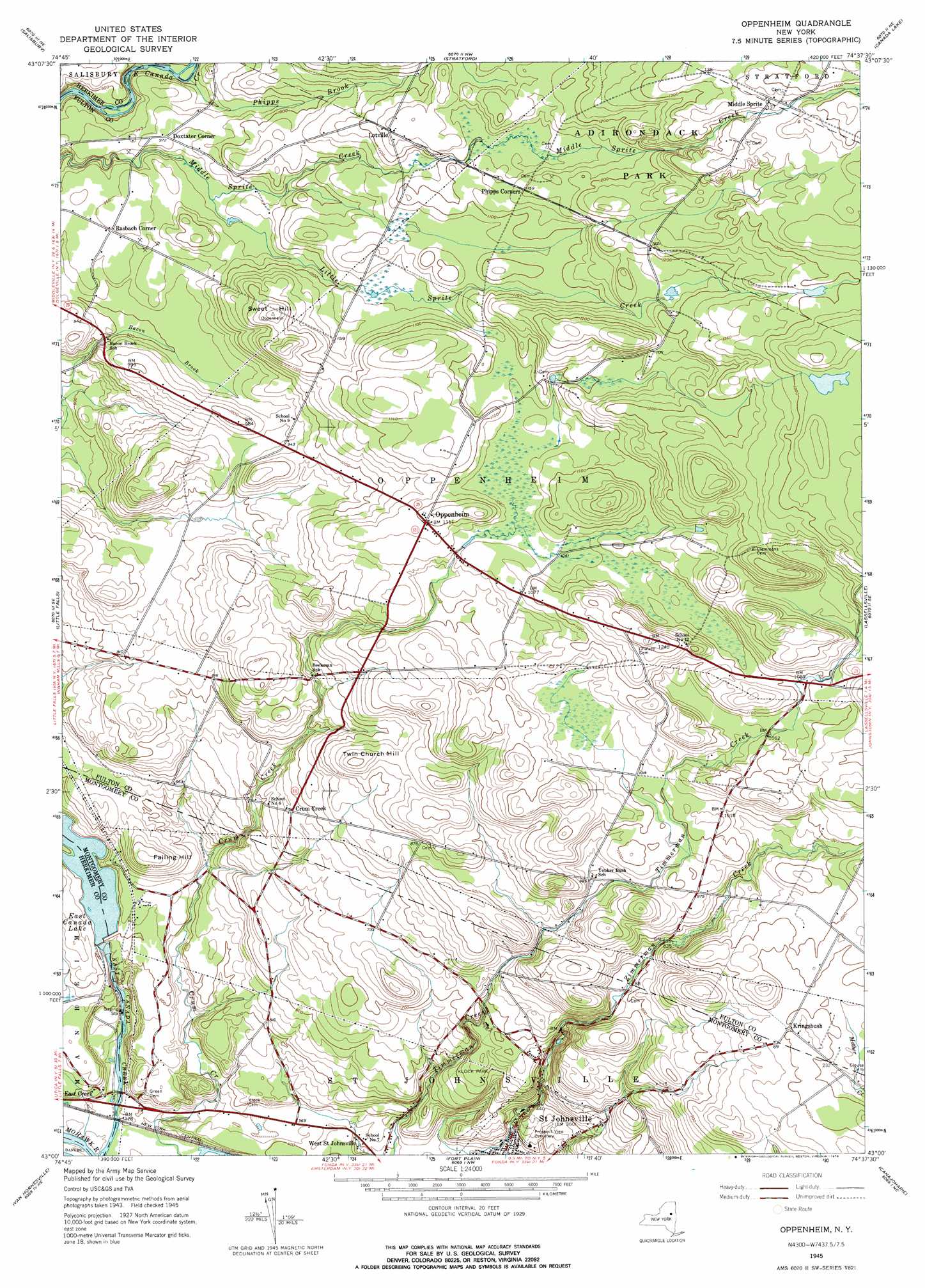
USGS Topo Quad 43074a6 - 1:24,000 scale
| Topo Map Name: | Oppenheim |
| USGS Topo Quad ID: | 43074a6 |
| Print Size: | ca. 21 1/4" wide x 27" high |
| Southeast Coordinates: | 43° N latitude / 74.625° W longitude |
| Map Center Coordinates: | 43.0625° N latitude / 74.6875° W longitude |
| U.S. State: | NY |
| Filename: | o43074a6.jpg |
| Download Map JPG Image: | Oppenheim topo map 1:24,000 scale |
| Map Type: | Topographic |
| Topo Series: | 7.5´ |
| Map Scale: | 1:24,000 |
| Source of Map Images: | United States Geological Survey (USGS) |
| Alternate Map Versions: |
Oppenheim NY 1945, updated 1966 Download PDF Buy paper map Oppenheim NY 1945, updated 1976 Download PDF Buy paper map Oppenheim NY 2010 Download PDF Buy paper map Oppenheim NY 2013 Download PDF Buy paper map Oppenheim NY 2016 Download PDF Buy paper map |
1:24,000 Topo Quads surrounding Oppenheim
Jerseyfield Lake |
Tomany Mountain |
|||
Middleville |
Salisbury |
Stratford |
Canada Lake |
Caroga Lake |
Herkimer |
Little Falls |
Oppenheim |
Lassellsville |
Peck Lake |
Jordanville |
Van Hornesville |
Fort Plain |
Canajoharie |
Randall |
Richfield Springs |
East Springfield |
Sprout Brook |
Sharon Springs |
Carlisle |
> Back to 43074a1 at 1:100,000 scale
> Back to 43074a1 at 1:250,000 scale
> Back to U.S. Topo Maps home
Oppenheim topo map: Gazetteer
Oppenheim: Airports
Dolgeville Airport elevation 287m 941′Oppenheim: Mines
Saint Johnsville Quarry elevation 166m 544′Oppenheim: Parks
Klock Park elevation 189m 620′Oppenheim: Populated Places
Crum Creek elevation 234m 767′Doxtater Corner elevation 294m 964′
East Creek elevation 108m 354′
Kringsbush elevation 305m 1000′
Lotville elevation 345m 1131′
Middle Sprite elevation 416m 1364′
Oppenheim elevation 334m 1095′
Rasbach Corner elevation 292m 958′
Oppenheim: Reservoirs
East Canada Lake elevation 148m 485′Oppenheim: Streams
Little Sprite Creek elevation 284m 931′Oppenheim: Summits
Failing Hill elevation 220m 721′Sweet Hill elevation 355m 1164′
Twin Church Hill elevation 307m 1007′
Oppenheim digital topo map on disk
Buy this Oppenheim topo map showing relief, roads, GPS coordinates and other geographical features, as a high-resolution digital map file on DVD:
New York, Vermont, Connecticut & Western Massachusetts
Buy digital topo maps: New York, Vermont, Connecticut & Western Massachusetts