Jerseyfield Lake Topo Map New York
To zoom in, hover over the map of Jerseyfield Lake
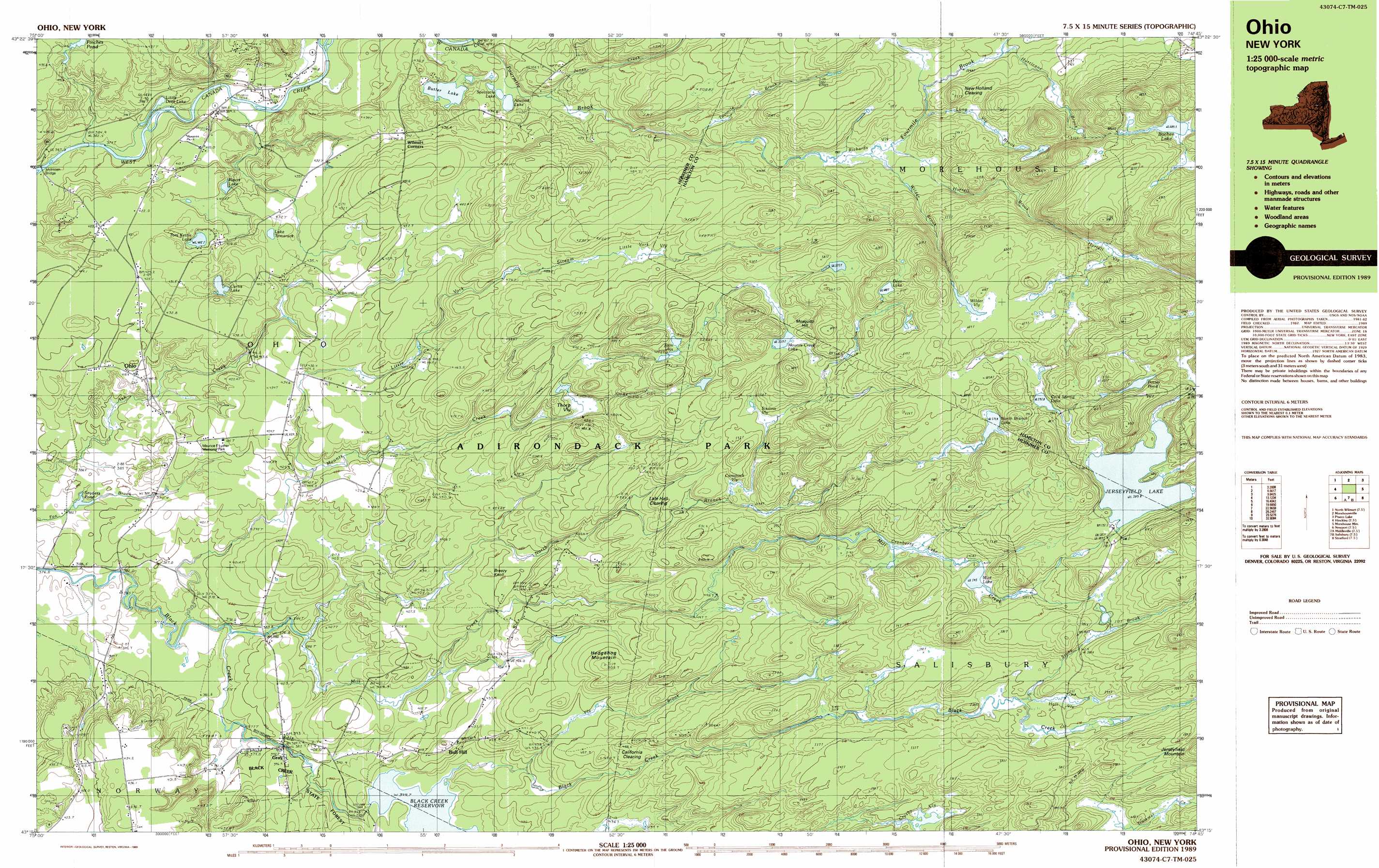
USGS Topo Quad 43074c7 - 1:25,000 scale
| Topo Map Name: | Jerseyfield Lake |
| USGS Topo Quad ID: | 43074c7 |
| Print Size: | ca. 39" wide x 24" high |
| Southeast Coordinates: | 43.25° N latitude / 74.75° W longitude |
| Map Center Coordinates: | 43.3125° N latitude / 74.875° W longitude |
| U.S. State: | NY |
| Filename: | k43074c7.jpg |
| Download Map JPG Image: | Jerseyfield Lake topo map 1:25,000 scale |
| Map Type: | Topographic |
| Topo Series: | 7.5´x15´ |
| Map Scale: | 1:25,000 |
| Source of Map Images: | United States Geological Survey (USGS) |
| Alternate Map Versions: |
Ohio NY 1989, updated 1989 Download PDF Buy paper map |
1:24,000 Topo Quads surrounding Jerseyfield Lake
Otter Lake |
Honnedaga Lake |
Spruce Lake |
||
North Wilmurt |
Morehouseville |
Piseco Lake |
||
Hinckley |
Jerseyfield Lake |
Tomany Mountain |
||
Newport |
Middleville |
Salisbury |
Stratford |
Canada Lake |
Ilion |
Herkimer |
Little Falls |
Oppenheim |
Lassellsville |
> Back to 43074a1 at 1:100,000 scale
> Back to 43074a1 at 1:250,000 scale
> Back to U.S. Topo Maps home
Jerseyfield Lake topo map: Gazetteer
Jerseyfield Lake: Airports
Kermizian Airport elevation 436m 1430′Jerseyfield Lake: Bridges
McIntosh Bridge elevation 373m 1223′Jerseyfield Lake: Flats
California Clearing elevation 457m 1499′Lafe Hall Clearing elevation 497m 1630′
New Holland Clearing elevation 517m 1696′
Jerseyfield Lake: Forests
Black Creek State Forest elevation 396m 1299′Jerseyfield Lake: Lakes
Atwood Lake elevation 424m 1391′Bochen Lake elevation 609m 1998′
Cold Spring elevation 593m 1945′
Cranberry Lake elevation 544m 1784′
Curtis Lake elevation 423m 1387′
Deer Lake elevation 608m 1994′
Figert Lake elevation 412m 1351′
Jerseyfield Lake elevation 590m 1935′
Lake Tamarack elevation 436m 1430′
Little Deer Lake elevation 387m 1269′
Mounts Creek Lake elevation 559m 1833′
Mud Lake elevation 545m 1788′
North Branch elevation 575m 1886′
Potter Pond elevation 620m 2034′
Spectacle Lake elevation 424m 1391′
Tom Kettle Lake elevation 415m 1361′
Jerseyfield Lake: Parks
Maurice F Luther Memorial Park elevation 419m 1374′Jerseyfield Lake: Populated Places
Bull Hill elevation 437m 1433′Gray elevation 391m 1282′
Ohio elevation 418m 1371′
Jerseyfield Lake: Reservoirs
Black Creek Reservoir elevation 399m 1309′Finches Pond elevation 432m 1417′
Snyders Pond elevation 384m 1259′
Jerseyfield Lake: Streams
Concklin Brook elevation 373m 1223′Fourmile Brook elevation 429m 1407′
Hurrell Brook elevation 486m 1594′
Hurricane Brook elevation 509m 1669′
Jones Creek elevation 413m 1354′
Little York Stream elevation 408m 1338′
Long Vly Brook elevation 497m 1630′
Mill Creek elevation 373m 1223′
Mounts Creek elevation 376m 1233′
North Branch Mill Creek elevation 385m 1263′
Stony Brook elevation 529m 1735′
Twomile Brook elevation 461m 1512′
Vly Brook elevation 399m 1309′
Wilder Brook elevation 482m 1581′
Jerseyfield Lake: Summits
Breezy Knoll elevation 456m 1496′Hedgehog Mountain elevation 499m 1637′
Mosquito Hill elevation 603m 1978′
Jerseyfield Lake: Swamps
Comstock Vly elevation 521m 1709′Crosby Vly elevation 532m 1745′
Hall Vly elevation 537m 1761′
Hurrell Vly elevation 583m 1912′
Little York Vly elevation 496m 1627′
Richards Vly elevation 480m 1574′
Sissons Vly elevation 533m 1748′
Thorp Vly elevation 471m 1545′
Twin Vlys elevation 532m 1745′
Wilder Vly elevation 610m 2001′
Jerseyfield Lake: Trails
California Trail elevation 457m 1499′Jerseyfield Lake digital topo map on disk
Buy this Jerseyfield Lake topo map showing relief, roads, GPS coordinates and other geographical features, as a high-resolution digital map file on DVD:
New York, Vermont, Connecticut & Western Massachusetts
Buy digital topo maps: New York, Vermont, Connecticut & Western Massachusetts