Bakers Mills Topo Map New York
To zoom in, hover over the map of Bakers Mills
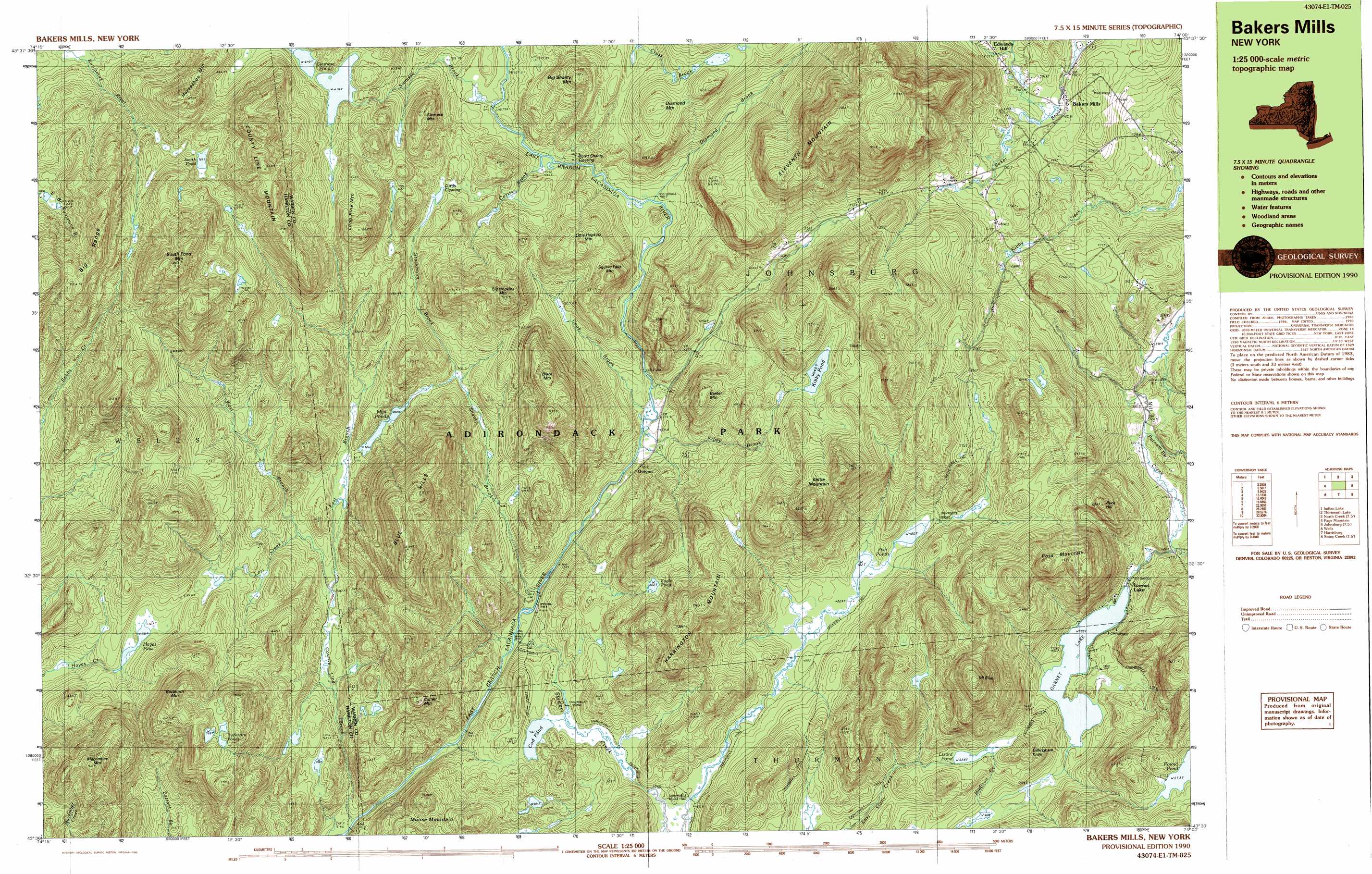
USGS Topo Quad 43074e1 - 1:25,000 scale
| Topo Map Name: | Bakers Mills |
| USGS Topo Quad ID: | 43074e1 |
| Print Size: | ca. 39" wide x 24" high |
| Southeast Coordinates: | 43.5° N latitude / 74° W longitude |
| Map Center Coordinates: | 43.5625° N latitude / 74.125° W longitude |
| U.S. State: | NY |
| Filename: | k43074e1.jpg |
| Download Map JPG Image: | Bakers Mills topo map 1:25,000 scale |
| Map Type: | Topographic |
| Topo Series: | 7.5´x15´ |
| Map Scale: | 1:25,000 |
| Source of Map Images: | United States Geological Survey (USGS) |
| Alternate Map Versions: |
Bakers Mills NY 1990, updated 1990 Download PDF Buy paper map Bakers Mills NY 1997, updated 2000 Download PDF Buy paper map |
1:24,000 Topo Quads surrounding Bakers Mills
Burgess Mountain |
Starbuck Mountain |
Schroon Lake |
||
Sabael |
Gore Mountain |
North Creek |
Chestertown |
|
Kunjamuk River |
Bakers Mills |
Johnsburg |
The Glen |
|
Wells |
Harrisburg |
Stony Creek |
Warrensburg |
|
Cathead Mountain |
Ohmer Mountain |
Conklingville |
Lake Luzerne |
> Back to 43074e1 at 1:100,000 scale
> Back to 43074a1 at 1:250,000 scale
> Back to U.S. Topo Maps home
Bakers Mills topo map: Gazetteer
Bakers Mills: Flats
Burnt Shanty Clearing elevation 498m 1633′Curtis Clearing elevation 555m 1820′
Bakers Mills: Lakes
Buckhorn Ponds elevation 750m 2460′Cod Pond elevation 461m 1512′
Eagle Pond elevation 602m 1975′
Fish Ponds elevation 483m 1584′
Garnet Lake elevation 448m 1469′
Hayes Flow elevation 576m 1889′
Kibby Pond elevation 640m 2099′
Lizard Pond elevation 528m 1732′
Mud Ponds elevation 504m 1653′
Round Pond elevation 573m 1879′
Siamese Ponds elevation 646m 2119′
South Pond elevation 705m 2312′
Bakers Mills: Populated Places
Bakers Mills elevation 486m 1594′Garnet Lake elevation 447m 1466′
Oregon elevation 444m 1456′
Bakers Mills: Streams
Cook Brook elevation 422m 1384′County Line Brook elevation 397m 1302′
Curtis Brook elevation 495m 1624′
Diamond Brook elevation 487m 1597′
East Branch County Line Brook elevation 480m 1574′
Kibby Brook elevation 421m 1381′
Lost Creek elevation 492m 1614′
Pine Ridge Brook elevation 426m 1397′
Putnam Brook elevation 424m 1391′
Shanty Brook elevation 410m 1345′
Siamese Brook elevation 492m 1614′
Stewart Creek elevation 409m 1341′
Stockholm Brook elevation 501m 1643′
West Branch County Line Brook elevation 480m 1574′
Bakers Mills: Summits
Barker Mountain elevation 633m 2076′Big Hopkins Mountain elevation 757m 2483′
Big Shanty Mountain elevation 710m 2329′
Black Mountain elevation 768m 2519′
Blue Hills elevation 877m 2877′
Buck Hill elevation 683m 2240′
Buckhorn Mountain elevation 877m 2877′
Corner Mountain elevation 697m 2286′
County Line Mountain elevation 939m 3080′
Diamond Mountain elevation 687m 2253′
Eleventh Mountain elevation 1004m 3293′
Gillingham Knoll elevation 581m 1906′
Harrington Mountain elevation 783m 2568′
Horseshoe Mountain elevation 841m 2759′
Kettle Mountain elevation 816m 2677′
Little Hopkins Mountain elevation 664m 2178′
Long Pine Mountain elevation 806m 2644′
Macomber Mountain elevation 891m 2923′
Moose Mountain elevation 602m 1975′
Mount Blue elevation 885m 2903′
Ross Mountain elevation 800m 2624′
Siamese Mountain elevation 702m 2303′
South Pond Mountain elevation 993m 3257′
Square Falls Mountain elevation 674m 2211′
Bakers Mills: Trails
Oregon Trail elevation 459m 1505′Bakers Mills digital topo map on disk
Buy this Bakers Mills topo map showing relief, roads, GPS coordinates and other geographical features, as a high-resolution digital map file on DVD:
New York, Vermont, Connecticut & Western Massachusetts
Buy digital topo maps: New York, Vermont, Connecticut & Western Massachusetts